
Langtang National Park protects about 1,710 square kilometres of the central Himalaya directly north of Kathmandu, with its southern boundary roughly 30 kilometres from the city. Gazetted in 1976, it runs from around 790 metres in the lower river gorges to just over 7,200 metres on Langtang Lirung, and shelters red panda, Himalayan black bear, musk deer and snow leopard. Gosaikunda, the sacred lake at about 4,380 metres inside the park, was listed as a Ramsar wetland of international importance in 2007.
Where is Langtang National Park and how do you reach it?
The park occupies the block of mountains between the Kathmandu valley and the Tibetan border, spanning parts of Rasuwa, Nuwakot and Sindhupalchok districts. Its proximity to the capital is its defining practical feature: this is the nearest high-mountain national park to Kathmandu, and you can be at a trailhead at 1,460 metres the same day you leave the city. The road runs roughly 120 kilometres north through Trishuli Bazaar and Dhunche to Syabrubesi, and takes six to eight hours depending on the state of the surface. Trekkers heading for Gosaikunda usually start at Dhunche instead, higher up the same road, and some walk in over the Shivapuri ridge from the valley rim.
That accessibility has an obvious consequence. Langtang delivers glaciers, yak pasture and 7,000-metre walls on a one-week schedule, without a flight and without a restricted-area permit. It is the sensible choice when Everest and Annapurna are too long or too busy.
What wildlife lives in Langtang National Park?
The species list is one of the strongest in Nepal for its size, mainly because the altitude range is so wide. Red panda is the flagship, living in the bamboo understorey beneath oak and rhododendron between roughly 2,200 and 3,600 metres, and Langtang is one of the better parks in the country for the species even though sightings remain uncommon and require patience at dawn. Himalayan black bear works the same forest belt. Himalayan musk deer, red panda and the Assamese macaque all sit on national and international threatened lists.
Higher up, the snow leopard occupies the alpine zone above the treeline, along with its main prey, the Himalayan tahr and the blue sheep. Ghoral and serow hold the steep mid-elevation ground. Common langur troops range through the lower forest. Wild dog have been recorded. More than 250 bird species have been listed inside the park, including Himalayan monal, satyr tragopan in the wet rhododendron forest, blood pheasant, snow partridge and lammergeier. In spring the rhododendron forest between Lama Hotel and Ghodatabela flowers in sequence up the hillside, and it is among the best rhododendron walks in the country.
What does the trek through the park actually look like?
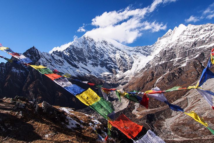
The standard Langtang valley route is a straight in-and-out up a glacial trench, climbing steadily out of dense forest into open yak pasture in about three days. It is a simple trek with a serious payoff at the top, where the valley opens beneath the ice cliffs of Langtang Lirung and the walking becomes almost horizontal.
| Stage | Route | Altitude | What changes |
|---|---|---|---|
| Day 1 | Syabrubesi to Lama Hotel | 1,460 m to 2,470 m | Riverside oak and bamboo forest; the red panda belt begins |
| Day 2 | Lama Hotel to Ghodatabela | 2,470 m to 3,030 m | Rhododendron and fir; first open views up the valley |
| Day 3 | Ghodatabela to Langtang village | 3,030 m to 3,430 m | Treeline, yak pasture, mani walls, the 2015 landslide scar |
| Day 4 | Langtang village to Kyanjin Gompa | 3,430 m to 3,870 m | Open glacial valley; monastery and the yak cheese factory |
| Day 5 | Acclimatisation day, Kyanjin Ri or Tserko Ri | up to about 4,985 m | Full panorama of Langtang Lirung, Langshisha Ri and the glacier |
| Days 6 to 7 | Return to Syabrubesi | down to 1,460 m | Two long descending days back through the forest belt |
The Tamang Heritage Trail is the alternative, looping west from Syabrubesi through Gatlang, Tatopani and Briddim at lower altitude, and it is the better choice if the interest is villages, hot springs and Tibetan-border culture rather than glaciers. The two can be joined into a ten to twelve day circuit, and Gosaikunda can be added over the Laurebina La for a longer route back toward the Kathmandu valley rim.
What happened to Langtang village in the 2015 earthquake?
The Gorkha earthquake of 25 April 2015 triggered a co-seismic avalanche and rock-ice fall from the flanks of Langtang Lirung that swept down onto Langtang village and buried it, together with a large part of the population and many of the trekkers and guides present that morning. The air blast alone flattened forest on the far side of the valley. It was the single deadliest incident of that earthquake outside the Kathmandu valley.
The valley reopened to trekking within a year and the village has since been rebuilt on a safer terrace slightly away from the original site, with new lodges run largely by the same families. Walking through it is a sober part of the trek, and the memorial and mani stones above the debris field are the appropriate place to stop. Local income depends almost entirely on trekkers returning, so visiting is not an intrusion.
Why is Gosaikunda a Ramsar site?
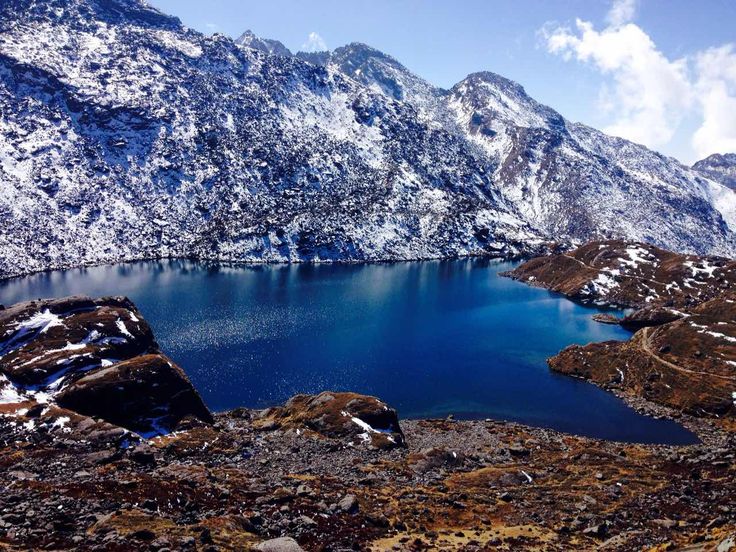
Gosaikunda sits at about 4,380 metres in a high basin on the southern side of the park, one of a cluster of more than a hundred small lakes, and it was designated a Ramsar wetland of international importance in 2007 together with the associated lakes around it. The ecological case is high-altitude freshwater habitat that is rare, discrete and under pressure. The cultural case is at least as strong. Hindu tradition holds that Shiva struck the mountain with his trident to create the lake, and at Janai Purnima in July or August thousands of pilgrims walk up from Dhunche and from the valley to bathe, making it one of the largest high-altitude pilgrimages in Nepal. Managing a Ramsar wetland that receives that many people in a single week is one of the harder jobs the park office has.
Who lives inside Langtang National Park?
Tamang communities occupy most of the middle hills inside the boundary, and the upper Langtang valley is settled by people of Tibetan descent whose herding, trade and monastic life run north across the border as much as south toward Kathmandu. The buffer zone declared in 1998 formalised resource rights for around forty thousand residents, and community forest user groups now manage a substantial part of the woodland on the park edge. The yak cheese factory at Kyanjin Gompa, a legacy of a Swiss-supported dairy programme from the middle of the last century, is still working and still the reason the high pasture is grazed the way it is. Between the park and the city sits Shivapuri Nagarjun National Park, the mid-hill park on the valley rim, which makes the two an easy pairing for anyone short on time.
What permits do you need for Langtang National Park?
Two documents. A Langtang National Park entry permit, checked at Dhunche on the way up, and a TIMS card. Neither Langtang valley nor Gosaikunda is a restricted area, so you do not need an agency-issued special permit or a mandatory guide arrangement of the kind required for Upper Mustang. Rates change, so confirm current figures before you leave Kathmandu. Drone flying inside the park requires written permission, and collecting firewood, plants or wildlife of any kind is prohibited.
FAQ
How big is Langtang National Park and when was it established?
It covers about 1,710 square kilometres and was gazetted in 1976. A buffer zone of roughly 420 square kilometres was added in 1998.
Can you see red pandas in Langtang National Park?
Langtang is one of the more reliable parks in Nepal for red panda, which live in the bamboo understorey roughly between 2,200 and 3,600 metres, but sightings are still uncommon. Your best chance is a slow dawn walk in the forest between Syabrubesi and Ghodatabela with a guide who knows the local feeding areas.
How long does the Langtang valley trek take?
Seven days from Kathmandu is the standard, including the drive each way and an acclimatisation day at Kyanjin Gompa. Adding the Tamang Heritage Trail or Gosaikunda takes it to ten to twelve days.
Is Langtang safe after the 2015 earthquake?
Yes. Trails, bridges and lodges have been rebuilt, Langtang village has been re-sited on safer ground, and the route has been operating normally for years. As anywhere in the Nepali Himalaya, check conditions after heavy monsoon rain, when landslides can close sections of the road and the lower trail.
Do you need a guide for Langtang?
Langtang is not a restricted area, so an agency permit is not required. A licensed guide is still strongly advised: the wildlife interest is almost entirely dependent on someone who knows the ground, and the descent from Gosaikunda over the Laurebina La can be genuinely difficult in snow.