
Sagarmatha National Park protects about 1,148 square kilometres of the Khumbu in north-east Nepal and contains Mount Everest, at 8,849 metres the highest mountain on earth, along with Lhotse, Nuptse, Cho Oyu and Ama Dablam. It was gazetted in 1976 and inscribed in 1979 as the first natural UNESCO World Heritage Site in Nepal. Almost the entire park lies above 3,000 metres, and a large share of its surface is bare rock, permanent snow and glacier ice.
What exactly does Sagarmatha National Park protect?
Three things at once, and the tension between them defines the place. It protects a glaciated high-mountain landscape of extraordinary scale, including the Khumbu Glacier and the Ngozumpa, generally described as the longest glacier in Nepal. It protects a genuinely fragile alpine ecosystem, where a birch and juniper forest cut for firewood takes generations to return at 4,000 metres. And it protects, or at least contains, the Sherpa communities of Namche Bazaar, Khumjung, Thame, Pangboche and a dozen other settlements who have farmed, herded and traded through these valleys for roughly five centuries and whose villages were inside the boundary when it was drawn.
That last point is unusual. The park was created around existing settlements rather than by clearing them, and in 2002 a buffer zone of about 275 square kilometres was declared to formalise resource rights for the residents. The Sherpa relationship with the land was already a conservation system of sorts: the shingi nawa, a village-appointed forest guardian, controlled who could cut which trees long before a warden arrived.
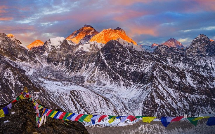
How high does the park go and what grows at each level?
The park spans roughly six thousand metres of vertical relief, from the Dudh Koshi gorge near the entrance gate at Monjo to the summit of Everest. Vegetation changes band by band and the change is abrupt, which makes the walk in an unusually legible lesson in mountain ecology. Blue pine, hemlock and Himalayan birch give way to fir and rhododendron, then to dwarf juniper and shrub, then to cushion plants and lichen, then to nothing at all.
| Zone | Approximate altitude | Dominant vegetation | Wildlife you might see |
|---|---|---|---|
| Lower forest | 2,800 to 3,500 m | Blue pine, hemlock, Himalayan birch, juniper | Himalayan tahr, musk deer, blood pheasant, Himalayan monal |
| Upper forest | 3,500 to 4,000 m | Silver fir, birch, rhododendron | Musk deer, yellow-billed chough, snowcock at the upper edge |
| Subalpine shrub | 4,000 to 4,500 m | Dwarf juniper, dwarf rhododendron, scrub willow | Himalayan tahr, snowcock, lammergeier and Himalayan griffon overhead |
| Alpine meadow | 4,500 to 5,000 m | Cushion plants, alpine grasses, edelweiss | Snow leopard tracks, Tibetan snowcock, alpine accentor |
| Nival zone | Above 5,000 m | Lichen, bare rock, permanent snow and ice | Choughs and the occasional griffon riding thermals; little else |
What wildlife lives in Sagarmatha National Park?
Fewer species than a lowland park, but the ones present are the ones people travel for. Himalayan tahr are common and easily seen on the steep ground above Namche and around Tengboche, often in herds of twenty or more. Himalayan musk deer, solitary and crepuscular, hold on in the birch and fir woods, and Tengboche monastery forest is the single most reliable place in the park to see one at dusk. Snow leopards have recolonised parts of the Khumbu and are periodically camera-trapped, though seeing one is close to a matter of luck. Himalayan black bear reach the lower valleys, red panda occur in the bamboo and rhododendron at the southern edge, and the pika, marten and weasel do most of the day-to-day mammal work.
The birds are excellent. Himalayan monal, the national bird, feeds on open slopes near the treeline and is easiest in early morning before the trekking traffic starts. Blood pheasant, Tibetan snowcock, snow pigeon, alpine chough and yellow-billed chough are all routine. Lammergeier and Himalayan griffon patrol the ridges, and the sight of a lammergeier with a nearly three-metre wingspan crossing below you on a ridge walk is one of the reliable pleasures of the Everest Base Camp route.
How do you enter Sagarmatha National Park?
Most people fly to Tenzing-Hillary Airport at Lukla, 2,845 metres, and walk north up the Dudh Koshi, formally entering the park at the Monjo checkpost where the entry permit is checked and the local rural municipality fee is collected. The overland alternative is a long drive to Salleri or Jiri followed by several days of walking, which is slower, cheaper and far better acclimatisation. Namche Bazaar at about 3,440 metres is the administrative and commercial centre, and the standard itinerary gives it two nights for acclimatisation before going higher. That pause is not optional. Altitude sickness is the most common serious medical problem inside the park, and the Himalayan Rescue Association aid post at Pheriche exists because of it.
Two main routes lead deeper in. The classic line runs Namche, Tengboche, Dingboche, Lobuche and Gorak Shep to Kala Patthar and Everest Base Camp. The quieter alternative runs north-west up the Dudh Koshi to the Gokyo lakes, a chain of turquoise glacial lakes on the eastern flank of the Ngozumpa Glacier that was designated a Ramsar wetland of international importance in 2007. Linking the two over the Cho La is the standard way to see both.
Why do glacial lakes matter in the Khumbu?
Because they have already burst. On 4 August 1985 the moraine dam holding Dig Tsho in the Langmoche valley failed, and the flood destroyed a nearly completed hydropower plant near Namche along with bridges, trails and farmland downstream. That event is the reason glacial lake outburst flood risk is now mapped and monitored across the Nepali Himalaya. Imja Tsho, below Imja Tse in the upper Khumbu, barely existed in the 1960s and has grown into one of the fastest-expanding glacial lakes in the country as the glacier behind it retreats. In 2016 an engineering team led by the Nepal Army lowered its water level by roughly three metres by cutting a controlled outlet channel, the first operation of its kind at that altitude anywhere. The park is therefore not a static landscape. It is one where the ice is measurably going, and where the hazard downstream is a management problem rather than a theoretical one.
What is being done about waste and crowding?
The Sagarmatha Pollution Control Committee, a locally run body established in 1991, handles solid waste across the Khumbu, operates collection and sorting, and administers the carry-out rules that require expeditions to bring their rubbish back down. Lodges have shifted substantially away from firewood toward kerosene, gas and small hydropower, which matters more than it sounds: firewood collection above the treeline was the single largest ecological pressure the park faced in its first two decades. Crowding on the main trail in the two peak windows, roughly March to May and October to November, remains real, and the simplest answer is to walk the Gokyo side, to add days rather than subtract them, or to look at quieter protected areas such as Kanchenjunga in the far east.
FAQ
When was Sagarmatha National Park established?
It was gazetted in 1976 and inscribed as a UNESCO World Heritage Site in 1979, the first natural World Heritage Site in Nepal. A buffer zone of about 275 square kilometres was added in 2002.
How big is Sagarmatha National Park and what is its altitude range?
About 1,148 square kilometres, plus the buffer zone. It runs from roughly 2,800 metres in the Dudh Koshi valley to 8,849 metres at the summit of Everest, a vertical span of around six kilometres.
Are there snow leopards in Sagarmatha National Park?
Yes. Snow leopards have recolonised parts of the Khumbu and are recorded regularly on camera traps and by their tracks and kills. Actually seeing one on a trek is extremely unlikely.
Do you need a permit to enter Sagarmatha National Park?
Yes. A national park entry permit is required and is checked at the Monjo post, and the local rural municipality collects a separate fee. Both can be arranged in Kathmandu or on arrival in the Khumbu. Check current rates before you travel.
Which is the best trek inside Sagarmatha National Park?
The Everest Base Camp and Kala Patthar route is the classic and the busiest. The Gokyo lakes route is quieter, arguably more beautiful and takes in a Ramsar-listed lake system. Combining the two over the Cho La pass is the strongest single itinerary if you have around eighteen days and are properly acclimatised.