
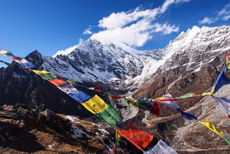
The Langtang valley runs east from Syabrubesi in Rasuwa district of Bagmati Province, ending at Kyanjin Gompa at 3,870 m beneath Langtang Lirung. It is the closest of the big Himalayan valleys to Kathmandu by road, and a seven to ten day return walk that needs no pass crossing and no restricted-area paperwork.
| Detail | Figure |
|---|---|
| Trail end | Kyanjin Gompa, 3,870 m |
| Road head | Syabrubesi, about 1,460 m |
| Drive from Kathmandu | about 7 hours by jeep, 8 to 9 by bus; roughly 120 km |
| District and province | Rasuwa, Bagmati |
| Protected area | Langtang National Park |
| Walking days | 7 to 10 return |
| Viewpoints above Kyanjin | Kyanjin Ri, about 4,300 m; Tserko Ri, about 4,980 m |
| Best months | March to May, October to November |
The drive is longer than the distance suggests
Langtang is often described as two hours from Kathmandu, and it is not. Syabrubesi is about 120 km away, but the road climbs over the Trishuli watershed and then descends a long stretch of rough surface, so the bus takes eight to nine hours and a private jeep seven. Leave Kathmandu early: the last part is not a road to drive after dark. What is true is that no flight is involved and no internal airstrip can cancel on you, which makes Langtang the most reliable of the major treks to schedule.
Permits are the Langtang National Park entry ticket and a TIMS card, both issued in Kathmandu and both charged per person. There is no restricted-area fee and no minimum group size, which keeps the cost of this trek well below Manaslu or Mustang. Our breakdown of travel costs by season gives realistic daily figures for a teahouse trek.
Walking up the valley
The trail leaves Syabrubesi, crosses the Langtang Khola and climbs through oak and bamboo forest to Lama Hotel at about 2,470 m, where langur monkeys are common and the valley is still narrow. The second day breaks out of the trees at Ghodatabela and reaches the valley floor proper. Mundu and Langtang village at around 3,430 m follow, and Kyanjin Gompa sits an easy half day beyond that.
Most itineraries then spend two nights at Kyanjin, and they should. There is a cheese factory, a small gompa, a glacier a short walk away, and two ridges that give the best views on the trek. Kyanjin Ri at roughly 4,300 m is a two hour climb straight up behind the lodges. Tserko Ri at about 4,980 m is a full day and a serious altitude gain, so do it on the second morning, not on arrival.
The 2015 avalanche and what you are walking through
On 25 April 2015 the earthquake released an ice and rock avalanche from the flank of Langtang Lirung that fell on Langtang village. Almost the entire settlement was buried, along with residents and trekkers. What you walk past today is a rebuilt village on a slightly different site, with a memorial wall listing the dead, above the boulder field the slide left behind.
Everyone in the valley remembers it, and most families lost someone. The rebuilding was done largely by the returning Tamang community, and the lodges above Ghodatabela are newer and better built than most in Nepal as a direct result. This is worth understanding before you arrive rather than being told at the memorial, and it is a straightforward reason to spend your money in the valley rather than treating it as a cheap short trek.
Side trips: Gosaikunda and the Tamang Heritage Trail
Two extensions turn a week into a fortnight. From Syabrubesi or Thulo Syabru the trail climbs south to Gosaikunda at 4,380 m, a chain of sacred lakes that draws thousands of pilgrims at Janai Purnima each August, and continues over the Laurebina pass to Helambu. Our Gosaikunda guide covers the pilgrimage and the pass.
The Tamang Heritage Trail loops north-west from Syabrubesi through Gatlang, Tatopani and Thuman at lower altitude, staying in village homestays rather than lodges. It is the better choice for anyone who wants the culture more than the height, and it works in months when the upper valley is cold. The national park itself, established in 1976 as the first in the Nepali Himalaya, protects red panda and Himalayan black bear and is described in our Langtang National Park guide.
Season and conditions
October and November give the clearest views of Langtang Lirung and the Ganesh range. March to May adds rhododendron in the mid-valley forest and warmer nights, with cloud building each afternoon. Winter is cold, and while the trail to Kyanjin stays open, snow closes the Laurebina pass towards Gosaikunda for months. The monsoon makes the road to Syabrubesi genuinely risky, with landslides a routine cause of multi-day delays, and that road is the reason to avoid July and August rather than the rain on the trail.
If you are choosing between Langtang and the bigger names, it costs the least of the three main teahouse regions, needs the fewest days and involves no flight. It also tops out lower, so the mountain views are closer but the sense of high altitude is milder. Our comparison of trekking regions lays that out, and the Kathmandu valley guide covers where the drive begins.
Frequently Asked Questions
How long does the Langtang valley trek take?
Seven to ten days return from Syabrubesi, including two nights at Kyanjin Gompa for the ridge climbs. Add four to six days to continue over Gosaikunda to Helambu.
How do you get to Syabrubesi from Kathmandu?
By road only. Public buses leave early from Machha Pokhari in Kathmandu and take eight to nine hours; a private jeep takes about seven. There is no airstrip serving the valley.
Do you need a guide for Langtang?
Nepal requires a licensed guide or porter-guide on its main trekking routes. Langtang is not a restricted area, so there is no minimum group size and no agency-only rule as there is on Manaslu.
Is Langtang safe after the 2015 earthquake?
Yes. The trail and lodges were rebuilt and have carried trekkers for years. The village site itself was moved clear of the avalanche path, and the current buildings are newer than most teahouses elsewhere in Nepal.
How high do you actually get in Langtang?
You sleep at 3,870 m at Kyanjin Gompa. The day climbs go higher: Kyanjin Ri at about 4,300 m and Tserko Ri at about 4,980 m, both returned the same day.