
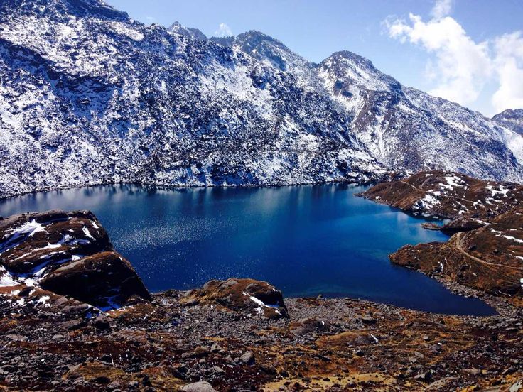
Gosaikunda is a glacial lake at about 4,380 metres in Rasuwa district, inside Langtang National Park, roughly 40 kilometres north of Kathmandu as the crow flies. It is the central lake in a cluster of high tarns traditionally counted as 108, and it is one of the most important Shaiva pilgrimage sites in Nepal: at the Janai Purnima full moon in July or August thousands of pilgrims walk up to bathe in water believed to have been released when Shiva struck the mountainside with his trident. The Gosaikunda lakes were designated a Ramsar wetland of international importance in 2007.
Why is Gosaikunda sacred?
The story begins with the churning of the cosmic ocean, when gods and demons turned the mountain to extract the nectar of immortality and drew up instead a poison capable of destroying creation. Shiva drank it and held it in his throat, which turned blue, earning him the name Nilkantha. Burning, he went north into the Himalaya and drove his trident into the mountainside to release cold water, and the pool that formed is Gosaikunda. The lake is therefore not a place where something holy happened; in the tradition it is a thing Shiva made, with his own hands, for his own relief.
Devotees hold that a rock formation visible in the lake is the reclining form of Shiva himself, most apparent when the water is low and clear. The same myth links Gosaikunda to the valley below by an underground channel: the water of the tank at the Budhanilkantha shrine below the Shivapuri hills north of Kathmandu, where a Licchavi-era Vishnu reclines on the cosmic ocean, is traditionally said to come from this lake, and the tank at Kumbheshwar in Patan is said to draw from it as well. That is why the shrines in Patan Durbar Square fill with bathers on the same festival day as a lake at 4,380 metres.
Buddhists in the surrounding Tamang villages also revere the lakes, and the site sits in a landscape of Tamang settlement and gompas rather than a Hindu heartland. This layering is normal in the Nepal Himalaya and it is one of the things that makes the walk in interesting: the pilgrimage is Hindu, the trail villages are Tibetan Buddhist, and the same peaks carry names in both traditions.
What happens at Janai Purnima?
Janai Purnima falls on the full moon of Shrawan, in late July or August, and it is the day when Brahmin and Chhetri men replace the janai, the sacred thread worn over the shoulder, and when many Nepalis tie a protective raksha bandhan thread on the wrist. At Gosaikunda it becomes a mass pilgrimage. Several thousand people climb to the lake over the preceding two days, bathe in water that is close to freezing, and hold vigil through the night.
Jhankris, the shamans of the middle hills and of Tamang and other communities, come in numbers, wearing headdresses and beating flat drums, and their presence gives the festival a character quite unlike a temple festival in the valley. Temporary shelters and food stalls appear along the trail from Dhunche and Sing Gompa, and the small settlement at the lake is overwhelmed for about seventy-two hours.
Go if you want to see it, but understand the conditions. This is the monsoon, so the trail is wet and leeches are active in the forest below 3,000 metres. Many pilgrims climb from about 2,000 to 4,380 metres in a day and a half, without acclimatisation, warm clothing or shelter, and serious altitude sickness and hypothermia occur at this festival every year. If you attend, walk it over three days, sleep low, and carry proper insulation and a waterproof layer. Accommodation cannot be relied on; assume you may be sleeping in a crowded room or in a tent.
How do you trek to Gosaikunda?
There are three usual approaches. The standard route starts at Dhunche, the district headquarters of Rasuwa at about 1,960 metres, reached by a road journey of roughly 117 kilometres and seven to eight hours from Kathmandu. From Dhunche the trail climbs through oak and rhododendron forest to Sing Gompa, also called Chandanbari, at about 3,330 metres, then up the Lauribina ridge to the lakes. Two days up from Dhunche is the minimum and three is much better.
The second approach comes from the Langtang valley itself, joining at Thulo Syabru, which allows you to do the main valley to Kyanjin Gompa first and then cross to the lakes with useful acclimatisation already banked. The third comes from the south, walking north from Sundarijal on the Kathmandu Valley rim through Chisapani, Kutumsang and Tharepati along the Helambu ridge, then over the Lauribina La pass at about 4,610 metres. Combining two of them, up from Dhunche and out through Helambu to Sundarijal, is the classic circuit and needs about a week.
| Day | Stage | Sleeping altitude | Time | Notes |
|---|---|---|---|---|
| 1 | Kathmandu to Dhunche by road | About 1,960 m | 7 to 8 hours driving | Roughly 117 km; jeep is faster and more reliable than the bus |
| 2 | Dhunche to Sing Gompa, or Chandanbari | About 3,330 m | 5 to 6 hours | Steady forest climb; local cheese is made here |
| 3 | Sing Gompa to Gosaikunda | About 4,380 m | 5 to 6 hours | Via Lauribina at about 3,900 m; the ridge view opens to Manaslu and Ganesh Himal |
| 4 | Gosaikunda over Lauribina La to Ghopte | About 3,440 m | 7 to 8 hours | Pass at about 4,610 m; usually snow-blocked from December to March |
| 5 | Ghopte to Tharepati and Kutumsang | About 2,470 m | 6 to 7 hours | Long descent onto the Helambu ridge |
| 6 | Kutumsang to Chisapani and Sundarijal | About 1,460 m | 6 to 7 hours | Finishes 45 minutes by road from Kathmandu |
How hard is the Gosaikunda trek?
It is short but not gentle. The distances are modest and the trail is well made, yet the climb from Dhunche to the lake gains about 2,400 metres in two days, which is steep by any standard, and the Lauribina La at roughly 4,610 metres is a genuine high pass. Altitude, not terrain, is the difficulty. Anyone sleeping at the lake is spending a night above 4,300 metres, and the standard symptoms of acute mountain sickness, headache, nausea, poor sleep and loss of appetite, are common there.
The mitigation is straightforward: add a night at Sing Gompa or Cholang Pati before going up, drink more water than feels necessary, and be prepared to descend if symptoms worsen rather than pushing on to the pass. Descent is the only reliable treatment and it is easy from here, since dropping 1,000 metres takes a few hours. Nights at the lake fall below freezing for much of the year, so a sleeping bag rated well below zero is not optional, and the teahouses at the lake are basic even by trekking standards.
What permits do you need for Gosaikunda?
The lake lies inside Langtang National Park, so you need a national park entry permit, and trekkers also require a Trekkers Information Management System card. Both are normally arranged in Kathmandu at the Nepal Tourism Board office in Bhrikutimandap, and the park permit can also be bought at the checkpost at Dhunche. Carry passport photographs and your passport. Fees differ for Nepali, SAARC and other foreign nationals and are revised periodically, so confirm the current amounts and the rules on independent trekking with the Department of National Parks and Wildlife Conservation or a registered agency before you travel rather than relying on published figures.
Rasuwa district borders Tibet and there are checkposts on the road; keep documents accessible. Mobile coverage exists in Dhunche and patchily higher up but should not be relied on at the lake.
When is the best time to trek to Gosaikunda?
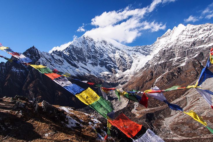
October and November are the best weeks of the year: stable weather, clear air, hard frost at night and the long northern views from the Lauribina ridge at their sharpest. March to May is the second window, warmer and with rhododendron in flower on the climb from Dhunche, though the air is hazier and afternoon cloud is common. From December to February the lake freezes, the teahouses at the top thin out or close, and the Lauribina La is usually impassable without winter equipment, so most winter visitors go up from Dhunche and come back the same way.
The monsoon, from mid-June to mid-September, brings rain, leeches and cloud, and it also brings Janai Purnima, which is the single reason to walk this trail in bad weather. Decide which experience you want. A pilgrimage in a crowd of several thousand and a quiet October morning at the same lake are not the same trip.
What can you combine it with?
The obvious pairing is the Langtang valley itself. Drive to Syabrubesi, walk up to Kyanjin Gompa at about 3,870 metres over three days, climb Kyanjin Ri or Tserko Ri for the acclimatisation and the view, then descend and cross to the lakes via Thulo Syabru. That produces a ten to twelve day trip with much better altitude preparation than the direct route, and it puts money into a valley that was devastated by the earthquake of 25 April 2015 and has been rebuilt since.
The Tamang Heritage Trail northwest of Syabrubesi adds two to four days of village walking at lower altitude and is a good warm-up. At the southern end, the Helambu exit passes through Sherpa and Tamang villages and finishes at Sundarijal on the valley rim, which makes for a satisfying arrival on foot into Kathmandu. Pilgrims who want to close the religious circle continue to Pashupatinath or to the tank at Kumbheshwar in Patan, both linked to the lake in tradition.
FAQ
How high is Gosaikunda lake?
About 4,380 metres above sea level, in Rasuwa district inside Langtang National Park. The Lauribina La pass on the route south towards Helambu is higher again, at roughly 4,610 metres, and is usually blocked by snow from December to March.
How many days does the Gosaikunda trek take?
Three days up from Dhunche is the sensible minimum, with a night at Sing Gompa for acclimatisation, and five to six days there and back. Continuing over the Lauribina La and out through Helambu to Sundarijal makes it a six to seven day walk plus travel days.
When is the Gosaikunda pilgrimage festival?
Janai Purnima, on the full moon of Shrawan in late July or August. Several thousand pilgrims bathe in the lake and hold an overnight vigil. It falls in the monsoon, so expect rain, leeches on the forest sections and cold, crowded conditions at the lake itself.
What permits do I need for the Gosaikunda trek?
A Langtang National Park entry permit and a Trekkers Information Management System card. Arrange them in Kathmandu at the Nepal Tourism Board, or buy the park permit at the Dhunche checkpost. Fees vary by nationality and are revised periodically, so confirm current rates before travelling.
Is Gosaikunda dangerous because of altitude?
It carries a real risk. Sleeping above 4,300 metres after a fast climb from below 2,000 metres causes altitude sickness in many people, and cases are frequent during the festival when unacclimatised pilgrims go up quickly. Add an acclimatisation night, carry warm gear and descend at the first sign of worsening symptoms.