
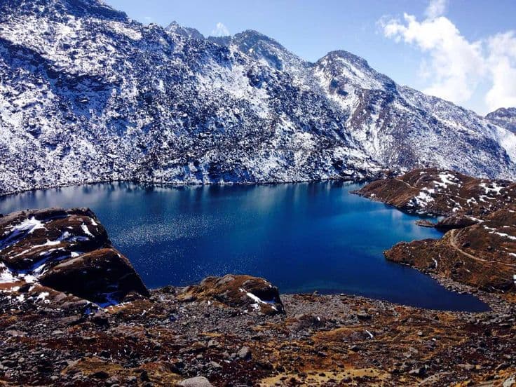
Gosaikunda is a glacial lake at 4,380 m in Rasuwa district, Bagmati Province, inside Langtang National Park. It is the largest of a cluster of high lakes on the ridge above Dhunche, sacred to Shiva, and the destination of a mass pilgrimage on the August full moon. Trekkers reach it in three or four days from the road head.
The story the lake is famous for
In the churning of the ocean, the gods and demons turn up a poison called halahala before they turn up the nectar of immortality. Shiva swallows it to save the world, his throat burns and turns blue, and he goes north into the mountains to cool himself. Finding no water, he strikes the rock with his trident and three springs open. The lake that forms is Gosaikunda, and a rock visible in the water when the level drops is identified as Shiva lying beneath the surface.
A related belief holds that the water travels underground and surfaces at the Kumbheshwar tank in Lalitpur, which is why pilgrims who cannot make the walk bathe there instead. If you have been to Patan Durbar Square you have been within a few minutes' walk of the other end of that story.
Gosaikunda at a glance
| Detail | Gosaikunda |
|---|---|
| District | Rasuwa |
| Province | Bagmati |
| Elevation | 4,380 m |
| Protected area | Langtang National Park |
| Ramsar listing | 2007, with the associated lakes |
| Road heads | Dhunche or Syabrubesi |
| Walking days from Dhunche | Three to four up, two down |
| Lauribina La pass | 4,610 m, the route east to Helambu |
| Peak pilgrimage | Janai Purnima, the August full moon |
| Permits | Langtang National Park entry permit and a TIMS card |
The walk in from Dhunche or Syabrubesi
Both road heads are a long day from Kathmandu by bus or jeep on a road that is rough and, in the monsoon, unreliable. From Dhunche the trail climbs steeply through oak and rhododendron to Deurali and Chandanbari, also called Sing Gompa, at around 3,300 m, where there is a cheese factory and a monastery. The second day continues up an exposed ridge past Cholangpati and Lauribina to the first of the lakes, Saraswati Kunda, then Bhairav Kunda, then Gosaikunda itself.
The gain from Dhunche to the lake is close to 2,400 m, which is the whole difficulty of this trek in one number. It is not technical and there is no exposure to speak of, but it is steep, sustained and high, and lodges above Sing Gompa are basic, cold and short of water. Splitting the second day is the usual answer.
Janai Purnima: tens of thousands of people on a high ridge
On the full moon of Shrawan, in August, pilgrims come up from Kathmandu and the surrounding hills to bathe in the lake and to change the sacred thread. Many walk the whole way in two or three days with minimal equipment, sleeping under plastic sheeting on the ridge. Shamans of the Tamang and other hill communities come too, in white, drumming through the night. It is one of the largest high-altitude gatherings in Nepal and it is completely unlike the trekking season.
If you want to see it, accept the conditions: every lodge is full, prices rise, the trail is crowded, and August is the middle of the monsoon so the walk in is wet, leech-ridden and often cloud-bound. If you want the lake to yourself, come in October or in late spring. The way these lunar dates are set is covered in our festival calendar guide.
Crossing Lauribina La to Helambu
The lake is a fine destination in itself, but the better trek continues east over the Lauribina La at 4,610 m and descends through Phedi and Ghopte to Tharepati, then down into the Helambu valley and out to Melamchi or Sundarijal. That turns an out-and-back into a loop that ends within reach of Kathmandu without retracing a step, and it is often combined with the Langtang valley for an outing of ten to twelve days.
The pass itself is a long day with a rough, boulder-strewn descent on the eastern side, and it is the section most likely to be blocked by snow. Our Langtang National Park guide covers the wider network of routes and what the park protects.
Winter freezes it, monsoon hides it
The lake ices over in winter and the crossing to Helambu becomes a snow route needing proper equipment and experience. The monsoon brings cloud, leeches on the lower forest sections and slippery trails, though it also brings the pilgrimage and, on a clear afternoon between storms, some of the most dramatic light of the year. October and November are the driest and clearest months; March to May adds rhododendron in flower on the climb from Dhunche.
Gosaikunda and its neighbouring lakes were listed as a Ramsar wetland of international importance in 2007, which puts them alongside the lowland sites described in our Ramsar wetlands guide. Sacred protection came a great deal earlier than the paperwork.
Permits, and the altitude
You need a Langtang National Park entry permit and normally a TIMS card, both obtainable in Kathmandu and checked at Dhunche. There is no restricted-area permit for this route. Fees are set by the authorities and change, so confirm the current rate rather than trusting an old figure.
The altitude deserves more respect than the trek's reputation suggests. Sleeping at 4,380 m after two days of steep climbing catches people out, and the pilgrimage crowd, ascending fast with no acclimatisation, sees genuine cases every year. Spend a night at Sing Gompa, take the second day slowly and read our acclimatisation guide before you go. Deeper background on the site itself is in our Gosaikunda sacred lake guide.
Frequently Asked Questions
Where do I sleep on the way up?
Chandanbari, also called Sing Gompa, at around 3,300 m is the usual first night, with more lodges at Lauribina and at the lake itself. Everything above Sing Gompa is basic, cold and short of water, which is why most walkers split the second day.
How do I reach the road head from Kathmandu?
Dhunche and Syabrubesi are both a long day away by bus or jeep on a rough road that is unreliable in the monsoon. Dhunche is the usual start for the lake; Syabrubesi is the start for the Langtang valley.
Can I make it a loop rather than walking back down?
Yes, and it is the better trek. Crossing the Lauribina La at 4,610 m and descending through Tharepati into Helambu brings you out at Melamchi or Sundarijal without retracing a step.
Should I go during Janai Purnima?
Only if the gathering itself is what you want to see. Every lodge is full, the trail is crowded, and the August full moon falls in the middle of the monsoon, so the walk in is wet and often cloud-bound. For the lake on its own, come in October or in late spring.
Is the trek difficult?
It is not technical, but it climbs close to 2,400 m from Dhunche over two to three days and finishes above 4,300 m. The height gain and basic high lodges, rather than the terrain, are what make it demanding.
Can I do it in winter?
The lake can be reached in clear winter weather but it freezes over, and the Lauribina La crossing becomes a snow route requiring equipment and experience. Most walkers go in October and November or in spring.