
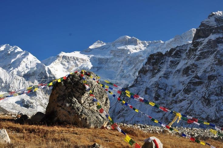
Kanchenjunga is the third-highest mountain in the world at 8,586 m, on the border between Nepal and Sikkim in Taplejung district of Koshi Province. Two base camps sit beneath it: Pangpema on the north side at about 5,143 m and Oktang on the south at about 4,730 m. Reaching either takes the better part of a month from Kathmandu.
| Detail | Figure |
|---|---|
| Summit | 8,586 m, third highest in the world |
| North base camp | Pangpema, about 5,143 m |
| South base camp | Oktang, about 4,730 m |
| District and province | Taplejung, Koshi |
| Protected area | Kanchenjunga Conservation Area |
| Nearest airport | Bhadrapur, then 8 to 10 hours by road |
| Walking days | 18 to 22 one side, 24 to 28 for both |
| Best months | March to May, October to November |
Getting to the far eastern corner of Nepal
The approach is the first serious commitment. Fly Kathmandu to Bhadrapur in the eastern Terai, then drive eight to ten hours north through the tea country of Ilam to Taplejung or Suketar. Buses run the same route in longer and less comfortable form. There is an airstrip at Suketar, but flights are irregular and should not be planned around. Add a spare day at each end for road conditions, which deteriorate quickly in wet weather.
From Taplejung the trail starts at Mitlung and follows the Tamor river north through Chiruwa and Sekathum, where the valley splits. That junction is the decision point of the whole trip: north for Pangpema, south for Oktang, or both if you have the days for the Sele La crossing between them.
Permits and the community conservation model
Kanchenjunga is a restricted area. The permit is issued through a registered Nepali agency, requires a licensed guide and a minimum of two trekkers, and is charged per person for a fixed period with an extension rate. You also need the Kanchenjunga Conservation Area entry permit, which is bought separately.
The conservation area covers a little over 2,000 square kilometres and is notable for how it is run: management was handed to a council of local user groups rather than kept with the national park service, which makes it one of the clearest examples of community-managed protected land in Nepal. Our Kanchenjunga Conservation Area guide covers the arrangement, and the protected area system explained puts it in context with the national parks.
The northern route to Pangpema
North of Sekathum the trail climbs the Ghunsa Khola through dense forest to Amjilosa and Gyabla, then reaches Ghunsa at about 3,595 m, the largest village on this side and the natural place for a rest day. Above it the valley opens onto moraine: Kambachen at roughly 4,145 m, Lhonak at about 4,780 m, and finally Pangpema, a flat shelf of glacial rubble looking straight at the north face of Kanchenjunga.
The section between Kambachen and Lhonak crosses an active rockfall slope and is walked early in the day for that reason. Pangpema itself is bleak and cold, with one or two seasonal shelters, and most groups go up and come back the same day from Lhonak rather than sleeping there.
The southern route to Oktang
The southern arm leaves the Tamor at Yamphudin and climbs over a series of forested ridges to Tseram and Ramche at about 4,600 m, below the Yalung glacier. Oktang, a short walk beyond, gives the view of the south-west face, which is the wall the 1955 first ascent was made on. This side is greener, lower and easier than the north, and it is the better half if you only have time for one.
Joining the two means crossing the Sele La ridge, a run of passes around 4,200 to 4,600 m between Ghunsa and Tseram, usually taken in one long day with an overnight at a high camp. That is what turns two out-and-back treks into a circuit, and it is the reason the full trip runs to nearly a month.
What you sleep in and what lives there
Lodges now exist along most of the main route, but they are basic: a room with two beds, a communal stove, and menus that shrink to dal bhat, noodles and eggs at the top. Several groups still carry tents for the Sele La section and for Pangpema, and any agency quoting the full circuit should say clearly which nights are camped. There is no ATM after Taplejung, no dependable mobile signal above Ghunsa and no road for evacuation from anywhere on the upper trail.
The compensation is what you walk through. The altitude range runs from subtropical forest in the lower valleys to permanent ice, which is why the area holds red panda, snow leopard, Himalayan black bear and a bird list that draws serious watchers. Our birdwatching guide covers the eastern forests, and the mountain itself sits alongside the country's other giants in our eight-thousanders guide.
Season and who it suits
October and November give the clearest weather and the most open lodges. March to May is warmer with rhododendron in the lower forest, though the eastern hills catch pre-monsoon cloud earlier in the day than the west. Winter closes the high sections and empties Ghunsa. The monsoon makes the drive from Bhadrapur genuinely unreliable and the lower trail leech-ridden.
This is not a first trek in Nepal. It asks for three to four weeks, tolerance for basic conditions and a real acclimatisation plan, described in our guide to acclimatisation. If that sounds like more than you want, Everest Base Camp reaches a comparable altitude in half the time with far better infrastructure, and our comparison of trekking regions sets the options side by side.
Frequently Asked Questions
How long is the Kanchenjunga Base Camp trek?
Eighteen to twenty-two walking days for one base camp, and twenty-four to twenty-eight to link both over the Sele La. Add three to four days for the flights and the long drive from Bhadrapur.
Do you need a permit for Kanchenjunga?
Yes, two. A restricted-area permit issued through a registered agency with a licensed guide and at least two trekkers, plus the Kanchenjunga Conservation Area entry permit.
Which base camp should you choose?
Oktang on the south side is lower, greener and easier, and it faces the wall of the 1955 first ascent. Pangpema on the north is higher, bleaker and more dramatic. If you only have time for one, most first visits take the south.
Are there teahouses on the Kanchenjunga trek?
Yes, along most of the main route, but they are simple and seasonal. The Sele La crossing and the highest camps often still need a tent, so check which nights your agency plans to camp.
How do you get to the Kanchenjunga trailhead?
Fly Kathmandu to Bhadrapur, then drive eight to ten hours to Taplejung. Flights to Suketar exist but are irregular. Allow a spare day at each end for weather and road conditions.