
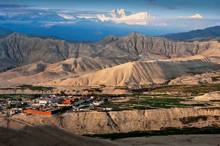
Upper Mustang is the arid, Tibetan-speaking district north of the Annapurna and Dhaulagiri ranges in Gandaki Province, centred on the walled town of Lo Manthang at about 3,840 m. It was closed to outside visitors until 1992 and is still a restricted area, entered from Kagbeni on foot or by jeep up the Kali Gandaki.
| Detail | Figure |
|---|---|
| Lo Manthang elevation | about 3,840 m |
| Entry checkpoint | Kagbeni, 2,800 m |
| Nearest airstrip | Jomsom, 2,720 m, flights from Pokhara |
| District and province | Mustang, Gandaki |
| Status | Restricted area, guide and permit required |
| Trekking days from Kagbeni | 10 to 14 return |
| By jeep from Jomsom | 1 to 2 days each way |
| Best months | April to early November, including the monsoon |
The one place in Nepal that is dry in July
Upper Mustang sits in the rain shadow of the Himalaya. The Kali Gandaki cuts straight through the range, and by the time the monsoon air has climbed over Annapurna and Dhaulagiri it has nothing left to drop. The result is a high desert of red and ochre cliffs, eroded gullies and irrigated green squares around each village, and a trekking season that runs from April to early November without a monsoon break.
That makes Mustang the answer to a specific problem: what to walk in July and August, when almost everywhere else in Nepal is under cloud. It also means no shade, strong sun at altitude and a wind that gets up in the late morning every day without exception. Walk early. Flights out of Jomsom leave before nine for the same reason.
Permits, guides and the cost of entry
Upper Mustang is restricted north of Kagbeni. Entry requires a restricted-area permit issued only through a registered Nepali trekking agency, a licensed guide, and a minimum of two trekkers on one permit. You also need the Annapurna Conservation Area permit, since the whole approach lies within it. The restricted permit is priced per person for a block of ten days with a per-day extension beyond that, and it is the most expensive of Nepal's area permits by a wide margin. Confirm current rates with your agency rather than trusting a figure on any website, including this one.
The checkpoint at Kagbeni records everyone going north and everyone coming back. There is no way to walk in without the paperwork. Our guide to restricted-area permits explains the system and how Mustang compares with Dolpa and Humla.
Walking it, or driving it
A rough jeep road now runs the whole way from Jomsom to Lo Manthang and on to the Chinese border at Korala. This has changed the trip completely. You can be in Lo Manthang two days after landing at Jomsom, and many visitors now do exactly that, which makes Upper Mustang accessible to people who cannot give it a fortnight.
Walkers who want the trek rather than the destination should ask for the eastern route on the way up, through Chele, Syangboche, Ghami and Tsarang, and the western route back through Ghar Gompa, Dhakmar and Ghiling, or the reverse. Both keep you off the road for most of the way. Ten to fourteen days from Kagbeni and back is the usual span. The days are short in distance but involve repeated climbs of 400 to 600 m in and out of dry side valleys, and the altitude sits between 3,000 m and 4,000 m throughout.
Lo Manthang, the caves and Tiji
Lo Manthang is a compact walled town of white houses around the royal palace and three old monasteries, Jampa, Thubchen and Chodey, whose fifteenth-century murals have been conserved over the past two decades. It is small enough to walk around in half an hour and repays two or three days. Local guides open the monasteries for visitors, and the fee goes to their upkeep.
North of the town at Chhoser are the sky caves: multi-storey chambers cut into a cliff face, reached by ladders, whose purpose is still argued over. Several thousand such caves are known across Mustang, some containing burials more than two thousand years old.
The Tiji festival at Lo Manthang runs for three days each spring, with masked dances in the palace square that enact the defeat of a demon. Its dates follow the Tibetan lunar calendar and usually fall in May, and accommodation in the town is booked out for it. If you want to see Tiji, plan a year ahead.
The valley below, and where the trade went
The Kali Gandaki carried salt south from Tibet and grain north for centuries, and Mustang existed because of that traffic. The road to Korala has partly revived it in the form of Chinese goods. Our guide to the trans-Himalayan salt trade explains how the economy worked, and the Gandaki river system covers the gorge itself, which is among the deepest in the world measured against the peaks on either side.
On the way in or out, the pilgrimage complex at Muktinath sits a short distance above Kagbeni and is worth a night in its own right; see our Muktinath guide. The Annapurna Circuit passes through the same checkpoint, so the two combine neatly, and the wider protected landscape is described in our Annapurna Conservation Area guide.
Frequently Asked Questions
Do you need a special permit for Upper Mustang?
Yes. North of Kagbeni is a restricted area. The permit is issued only through a registered Nepali agency, requires a licensed guide and a minimum of two trekkers, and comes on top of the Annapurna Conservation Area permit.
Can you visit Upper Mustang during the monsoon?
Yes, and it is one of the few places in Nepal where that makes sense. Mustang lies in the rain shadow of Annapurna and Dhaulagiri, so July and August are dry, though flights into Jomsom can still be delayed by weather further south.
Can you drive to Lo Manthang?
Yes. A rough jeep road runs from Jomsom to Lo Manthang and on to the border at Korala, taking one to two days each way. Walkers can use the older footpaths on either side of the valley to avoid most of it.
How high is Upper Mustang?
The route runs mostly between 3,000 m and 4,000 m, with Lo Manthang at about 3,840 m and several passes a little higher. Altitude sickness is possible but less common than on the base camp treks.
When is the Tiji festival held?
Tiji runs for three days at Lo Manthang each spring, on dates set by the Tibetan lunar calendar and usually falling in May. Beds in the town are booked out well in advance for it.