
The Annapurna Conservation Area covers 7,629 square kilometres across Manang, Mustang, Kaski, Lamjung and Myagdi districts, which makes it the largest protected area in Nepal. It was gazetted in 1992 after a pilot project began at Ghandruk in 1986, and it is managed by the National Trust for Nature Conservation under a government mandate rather than by the Nepal Army. Roughly a hundred thousand residents still farm, graze livestock and run lodges inside the boundary, because a conservation area is a multiple-use category and not a strict reserve.
How is a conservation area different from a national park in Nepal?
Nepal protects land under several legal categories, most of them created by the National Parks and Wildlife Conservation Act of 1973 and refined by the Conservation Area Management Regulations of 1996. A national park is strict protection. Permanent settlement, cultivation and commercial resource extraction are barred from the core zone, the boundary is patrolled by the Nepal Army, and the Department of National Parks and Wildlife Conservation runs management from Kathmandu. A conservation area inverts that logic. It starts from the fact that people already live on the land and builds the rules around them, permitting farming, controlled grazing, regulated firewood and timber collection, and private tourism enterprise inside the boundary.
The difference is obvious on the ground. Walk into Chitwan and you pass an army checkpost and see no villages in the core zone. Walk the Annapurna Circuit and you spend a fortnight in working settlements without meeting a soldier. Authority sits with Conservation Area Management Committees elected at village level, and in Annapurna those committees are supported by the National Trust for Nature Conservation, an autonomous non-government body created in 1982 and known until 2006 as the King Mahendra Trust for Nature Conservation. The trust also manages Manaslu and Gaurishankar. Api Nampa is run directly by the department, and Kanchenjunga was handed to a community council in 2006.
Money moves differently too. Entry fees collected inside a conservation area are retained for local conservation and development rather than being absorbed into the national treasury, so permit income pays for trail repair, micro-hydro schemes, drinking water pipelines, health posts and school buildings in the valleys trekkers walk through. Nepal now has six conservation areas: Annapurna, Manaslu, Kanchenjunga, Api Nampa, Gaurishankar and the small Blackbuck Conservation Area in the western Terai. Add twelve national parks, the wildlife reserve at Koshi Tappu, the hunting reserve at Dhorpatan and the buffer zones attached to most parks, and protected land covers close to a quarter of the country.
Where does the Annapurna Conservation Area begin and end?
The boundary wraps the entire Annapurna massif and the upper Kali Gandaki, running from subtropical foothills a short drive above Pokhara at under 1,000 metres to the summit of Annapurna I at 8,091 metres. That vertical spread of more than seven kilometres inside one management unit is the reason the area holds so many habitat types. The southern flank is monsoon country: rice terraces, banana, and dense rhododendron forest that flowers scarlet through March and April. North of the main Himalayan crest the rain stops. Manang and Mustang sit in a rain shadow, and the landscape turns to gravel, juniper scrub, cliff-cut caves and mud-brick villages that look and function like the Tibetan plateau, because culturally they belong to it.
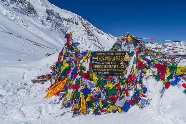
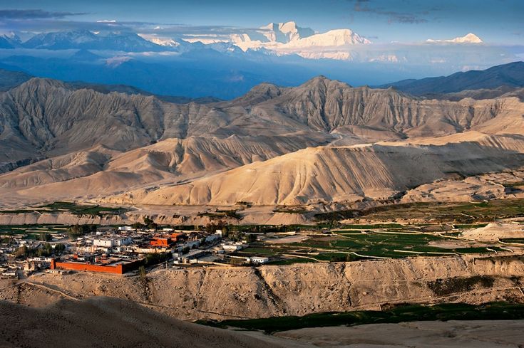
The Kali Gandaki cuts between Annapurna I and Dhaulagiri I at 8,167 metres, producing one of the deepest river gorges measured anywhere on earth. Above the gorge lies the walled town of Lo Manthang, capital of the old kingdom that gives Upper Mustang its restricted status and its dry, ochre landscape. To the east the Marsyangdi drains Manang and leads to Thorong La at 5,416 metres, still the standard crossing point of the circuit. A day north of Manang village sits Tilicho Lake at close to 4,920 metres, one of the highest lakes of its size anywhere in the world.
What wildlife and plants live in the Annapurna Conservation Area?
Snow leopard hold the high country in Manang, Mustang and Nar Phu, hunting blue sheep across broken ground above about 3,500 metres. They are seen rarely and photographed mostly by camera trap, but the National Trust for Nature Conservation has run long-term monitoring here and the population is considered one of the more secure in Nepal. Himalayan tahr work the cliffs on the southern side, musk deer hold the birch and juniper belt, and Himalayan black bear range through the middle-hill forests. Grey wolf and Tibetan argali occur in the trans-Himalayan north. Red panda are present in the eastern rhododendron and bamboo forests, though at low density and rarely on the main trails.
Bird interest is high in every season. The Himalayan monal, the national bird of Nepal, is common on open slopes between roughly 3,000 and 4,500 metres and is often flushed from the trail above Ghorepani at first light. Koklass and blood pheasant occur in the forest belt, lammergeier and Himalayan griffon patrol the gorges, and the Kali Gandaki is a recognised migration corridor where demoiselle cranes and raptors funnel south in autumn. Botanically the area is best known for rhododendron, of which Nepal holds dozens of species and a large share occur here. Residents are also permitted to harvest high-value medicinal plants under quota, including the caterpillar fungus known as yarsagumba in the alpine pastures of Manang and Mustang.
Which treks run through the Annapurna Conservation Area?
Almost every classic trek in central Nepal falls inside the boundary, which is why the Annapurna permit is the most issued conservation permit in the country. Routes range from a three-day forest walk to a three-week high crossing, and all of them start within a few hours of Pokhara.
| Trek | Typical days | Highest point | Difficulty | Best months |
|---|---|---|---|---|
| Annapurna Circuit | 14 to 18 | Thorong La, 5,416 m | Strenuous | Mar to May, Oct to Nov |
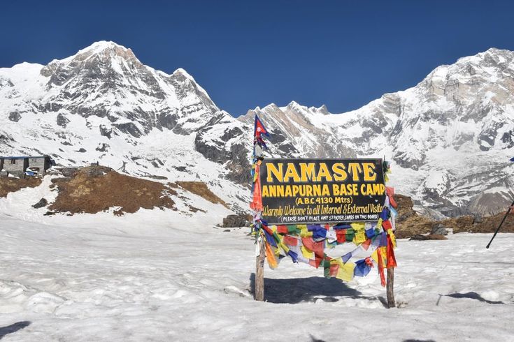
| Annapurna Base Camp | 7 to 11 | Sanctuary, about 4,130 m | Moderate | Mar to May, Oct to Nov |
| Ghorepani and Poon Hill | 3 to 5 | About 3,210 m | Easy | Oct to Dec, Mar to Apr |
| Upper Mustang to Lo Manthang | 10 to 14 | About 4,000 m | Moderate, restricted zone | Apr to Oct, monsoon included |
| Tilicho Lake side trip | 3 to 4 extra | Lake, about 4,920 m | Strenuous | Apr to May, Oct |
| Nar Phu Valley | 9 to 12 | Kang La, about 5,320 m | Strenuous, restricted zone | Apr to May, Sep to Oct |
Two of those routes sit inside restricted zones. Upper Mustang and Nar Phu need a separate restricted-area permit that is issued only through a registered trekking agency, with a minimum of two trekkers and a licensed guide. The remaining routes need the conservation area entry permit and the standard trekker record card, and they can be walked from lodge to lodge without camping equipment.
What permits do you need for the Annapurna Conservation Area?
Every foreign visitor entering the boundary needs an Annapurna Conservation Area Project entry permit, issued by the Nepal Tourism Board in Kathmandu or Pokhara, or bought at the checkpost on arrival at a higher rate. Nationals of SAARC countries pay a reduced rate and Nepali citizens enter free. You also need a Trekkers Information Management System card, and since 2023 the tourism board has required a licensed guide on most trekking routes, something restricted zones have always demanded. Fees are revised from time to time, so confirm the current figure with the tourism board or your operator rather than trusting an old blog post or a printed guidebook.
Checkposts sit at Besisahar, Dharapani, Chame, Jomsom, Ghasa and Birethanti among others, and staff record every permit number that passes. Carry photocopies of your passport and permit, because replacing a lost document in Manang is not realistically possible. Permit revenue is the operating budget of the whole conservation programme. It funds ranger salaries, tree nurseries and plantation work, waste management at the trailheads, kerosene and back-country fuel depots that reduce firewood pressure, and the community micro-hydro that keeps lodge lighting running above 3,500 metres.
When is the best time to trek in the Annapurna Conservation Area?
October and November are the most reliable months. The monsoon has cleared, visibility is long, and daytime temperatures at 3,500 metres are comfortable, though nights drop below freezing and Thorong La is bitter before sunrise. March to May is the second window and the better one for flowers, with rhododendron colouring the southern forests from mid-March at lower elevation and progressively later as you climb. Haze builds through late April and May, so long views are less dependable than in autumn.
June to September brings the monsoon, cloud on the peaks and heavy leech pressure on the southern approaches, but the rain shadow north of the crest stays dry. That makes summer the correct season for Upper Mustang, Nar Phu and upper Manang, which is the reverse of what most visitors assume. December to February is cold and quiet, with Thorong La frequently closed by snow for days at a time. The low Poon Hill circuit stays walkable through winter and the air is at its clearest of the year.
Has the road ruined the Annapurna Circuit?
Roads reached Manang and Muktinath during the 2010s and the classic circuit is no longer a continuous footpath. That is a genuine change and it is worth planning around rather than mourning. The National Trust for Nature Conservation and local committees cut alternative trails in response, the best known being the New Annapurna Trekking Trail and the high route through Ghyaru and Ngawal, which keep walkers off the road for most of the northern section and pass through older villages the highway bypassed. Jeeps also let trekkers who are short of time skip the lower Marsyangdi and start walking at Chame or Dharapani.
The road changed the economics of the valleys as well. Freight that once moved by mule now moves by truck, prices in Manang fell, and clinics and secondary schools became reachable in hours instead of days. Conservation area status did not stop the road and was never designed to. What it did was give elected local committees a formal say in where the alignment ran, how much forest came down and what share of tourism revenue stayed in the district. Judged as a strict wilderness reserve, Annapurna looks compromised. Judged as what it actually is, a multiple-use landscape where a hundred thousand people have to make a living, it remains the most successful protected-area experiment Nepal has run.
FAQ
How big is the Annapurna Conservation Area?
It covers 7,629 square kilometres, the largest single protected area in Nepal, spread across Manang, Mustang, Kaski, Lamjung and Myagdi districts and rising from subtropical foothills to the 8,091 metre summit of Annapurna I.
Who manages the Annapurna Conservation Area?
The National Trust for Nature Conservation manages it under a mandate from the Government of Nepal, working through Conservation Area Management Committees elected in the villages inside the boundary. Unlike a national park, it is not garrisoned or patrolled by the Nepal Army.
Do people live inside the Annapurna Conservation Area?
Yes. Roughly a hundred thousand people live inside the boundary and continue to farm, graze livestock, harvest medicinal plants under quota and run lodges. That is the defining feature of the conservation area category and the main way it differs from a national park.
Can you trek in the Annapurna region without a guide?
Restricted sections such as Upper Mustang and Nar Phu have always required a licensed guide and a registered agency. Since 2023 the Nepal Tourism Board has extended a guide requirement to most trekking routes, so budget for one and confirm the current rule before you travel.
Which is better, the Annapurna Circuit or Annapurna Base Camp?
Base Camp is shorter, lower and fits into a week, finishing in a glacial amphitheatre ringed by peaks. The circuit is longer and harder, crosses Thorong La at 5,416 metres, and shows far more variety because it passes from monsoon forest into trans-Himalayan desert. Choose Base Camp for a first Himalayan trek and the circuit if you have a fortnight and want the landscape to change under your feet.