
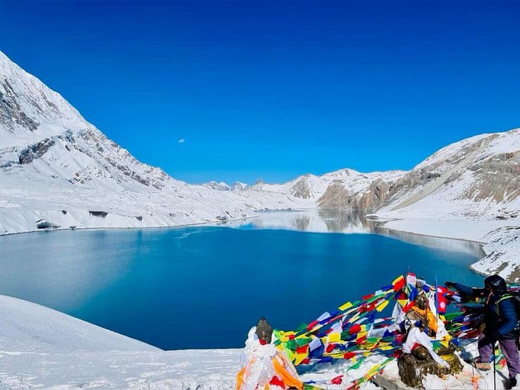
Tilicho Lake sits at 4,919 m in Manang district, Gandaki Province, in a rock basin on the northern flank of the Annapurna range. It is reached on a two to three day side trip from Manang village off the Annapurna Circuit, and for much of the year it is frozen. The approach crosses one of the most exposed sections of trail in the region.
Is it really the world's highest lake
No, and the claim is worth correcting before you plan around it. Higher lakes exist, including crater lakes high on Ojos del Salado in the Andes above 6,000 m and several on the Tibetan plateau. What is defensible is that Tilicho is one of the highest lakes of its size anywhere, and it is routinely described that way in the literature.
Published elevations vary by a few tens of metres depending on the survey, with 4,919 m the most widely cited figure and some sources giving slightly higher. Nothing about the trip depends on which is right. What matters is that you are sleeping and walking above 4,000 m for several days, which is where the real planning question sits.
The route from Manang
The side trip leaves the main circuit at Manang, or at Khangsar just beyond it. Day one runs from Manang to Khangsar and on to Tilicho Base Camp at about 4,150 m, four to six hours. Day two goes to the lake and back to base camp, four to six hours return with a climb of roughly 800 m to the shore and a descent the same day. Day three returns to Manang or continues to Yak Kharka to rejoin the circuit.
Some trekkers compress this into two days and some spread it over four by adding an acclimatisation night. The Besisahar road now reaches Manang and beyond towards Khangsar, which has shortened the walk in from Besisahar considerably and changed how people plan the circuit generally. That is convenience at a cost: arriving at Manang by jeep rather than on foot means arriving without the acclimatisation the walk used to provide.
There are lodges at Khangsar and at base camp. They are basic, cold and full in October, so an early start matters as much for a bed as for the weather. Nothing on this side trip is technical, but it is long, high and unforgiving of a bad day.
The landslide section
Between Khangsar and base camp the trail crosses a broad, actively eroding slope of loose scree and conglomerate above a steep drop. It is the section everyone talks about and the one genuine hazard on the route. Rockfall from above is the risk, and it increases as the day warms and as any snow above the traverse loosens.
Cross it early. Guides start before dawn for exactly this reason, move groups across in spaced intervals rather than bunched, and keep talking to a minimum so people can hear stones coming. Trekking poles help on the loose surface. In fresh snow the crossing becomes genuinely dangerous, and turning back is the correct decision rather than a failure.
This is one of the clearest arguments for hiring a local guide even if you would normally walk independently. They know the current state of the slope, which varies year to year and after every heavy monsoon.
Altitude: the part people underestimate
Tilicho is a high-altitude day walk tacked onto a trek that is already high. From base camp at around 4,150 m you climb close to 800 m and descend the same day, which is a serious effort at that elevation even for fit walkers. Headache, nausea and poor sleep at base camp are common and are the body telling you something.
The safeguard is time. Spend at least two nights at Manang at 3,540 m before starting, take an acclimatisation walk while you are there, and do not attempt the lake on the day you arrive at base camp if you feel unwell. Descend if symptoms worsen, and treat that as the plan rather than the failure of one. Our guide to altitude sickness and acclimatisation covers the symptoms and the decision rules in detail.
People with the Thorong La at 5,416 m still ahead of them sometimes treat Tilicho as useful acclimatisation. It can be, but only if it is done with proper rest days built around it rather than squeezed in to save time.
| Detail | Tilicho Lake |
|---|---|
| Elevation | About 4,919 m |
| District | Manang |
| Province | Gandaki |
| Base camp | Around 4,150 m |
| Nearest village with lodges | Khangsar, beyond Manang |
| Side trip length | 2 to 4 days from Manang |
| Permits | Annapurna Conservation Area entry permit and TIMS card |
| Season | Mid-March to May, and late September to early November |
| Main hazard | Rockfall on the scree traverse before base camp |
| Nearest airstrip | Manang, at Hongde, with unreliable flights |
Permits and season
Manang lies inside the Annapurna Conservation Area, so you need an ACAP entry permit and a TIMS card, both issued in Kathmandu or Pokhara. Fees are set per person with different rates for SAARC and other foreign nationals and are revised periodically, so check the current figures with the Nepal Tourism Board office rather than relying on an older published number. Manang is not a restricted area, so no restricted-area permit or mandatory guide arrangement applies here in the way it does in Dolpa, Humla and Mugu.
The season is short. Mid-March to May and late September to early November are the working windows. Outside them the lake is frozen, the traverse is snow-covered, and the base camp lodges close or run minimal service. October is the busiest month on the whole circuit, so the base camp lodges fill early in the afternoon.
If you are building this into a longer route, the Annapurna Circuit page covers the main trail, the conservation area guide covers the permit system, and Nepal's trekking regions compared is useful if you are still choosing between the Annapurna and the alternatives further west.
Frequently Asked Questions
How high is Tilicho Lake?
About 4,919 m, the most widely cited figure, with some surveys giving slightly higher. It is often marketed as the world's highest lake, which is not accurate; it is among the highest lakes of its size.
How many days does the Tilicho side trip take?
Two to four days from Manang. The standard is three: base camp on day one, the lake and back on day two, and a return to the circuit on day three. Adding a day improves both acclimatisation and your odds of clear weather.
Is the trail to Tilicho dangerous?
The scree traverse before base camp is the real hazard, with rockfall the main risk. Crossing early in the morning, spacing the group and turning back in fresh snow are the standard precautions. Nothing on the route is technical climbing.
Do I need a guide?
Not legally, since Manang is not a restricted area, but strongly recommended. The condition of the eroding slope changes year to year, and a local guide knows the current state of it and the right hour to cross.
What permits do I need?
An Annapurna Conservation Area entry permit and a TIMS card, both obtainable in Kathmandu or Pokhara. Rates differ for SAARC and other foreign nationals and are revised from time to time, so confirm the current amount before you travel.
When is Tilicho Lake not frozen?
Partially open water is usual in late spring and autumn, but the lake carries ice for much of the year and can be entirely frozen even in season. Treat an ice-covered lake as the likely sight rather than a disappointment.