
Kapilvastu is a Terai district in Lumbini Province, on the Indian border west of Lumbini. Its headquarters is Taulihawa. It is known for Tilaurakot, the archaeological site widely identified as the Shakya capital where Siddhartha Gautama spent his first twenty-nine years, and for the Ashokan pillars at Niglihawa and Gotihawa.
That summary carries an argument inside it, and the argument is the most interesting thing about the district. Lumbini, thirty-odd kilometres east, is settled: the birthplace is marked, inscribed and visited by hundreds of thousands of people a year. Kapilvastu, where the same person then lived for nearly three decades, is a set of brick foundations in farmland with a fraction of the visitors and none of the certainty. Whether Tilaurakot is the Kapilavastu of the early texts has been contested by archaeologists for over a century, and it is contested still.
Where is Kapilvastu?
Kapilvastu sits in the western Terai, the flat alluvial belt along Nepal's southern border. Rupandehi lies to the east, Arghakhanchi and Palpa in the hills to the north, Dang to the north-west, and the Indian state of Uttar Pradesh across the border to the south and west. The Banganga river runs through the middle of the district and past Tilaurakot itself, which is not incidental: the ancient site sits where it does because of that water.
The land is level, farmed hard, and hot. Most of the district lies on the plain, with a strip of low Chure hills along the northern edge where the Terai starts to lift. Paddy dominates the wet season and wheat and mustard the dry one. Villages are compact and close together, and the road network between them is dense but mostly narrow and unsealed once you leave the main routes.
Administratively the headquarters is Taulihawa, a market town in Kapilvastu Municipality. Confusingly for visitors, the town, the municipality and the district all carry versions of the same name, and locals use Taulihawa and Kapilvastu interchangeably in speech. If you are asking directions, Taulihawa is the more reliable word. The wider administrative picture for districts like this one is set out in our guide to Nepal's 77 districts.
Was Tilaurakot the real Kapilavastu?
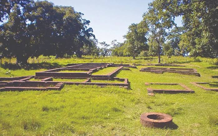
Tilaurakot is a rectangular walled site on the east bank of the Banganga, roughly three kilometres north of Taulihawa. Excavation has exposed a rampart, moat traces, gateways on the eastern and western sides, and structural remains inside the enclosure. It sits on Nepal's tentative list for UNESCO World Heritage inscription, together with the associated sites around it.
The competing candidate is Piprahwa, across the border in Uttar Pradesh, where a stupa excavated in the nineteenth century produced a reliquary with an inscription referring to the Buddha's relics and the Shakya clan. Both sites have serious scholarship behind them, the disagreement has run since the 1890s without resolution, and archaeological work has continued at each without settling it.
For a visitor, that unresolved state is worth knowing before you arrive, because it changes what you are looking at. Tilaurakot is not presented as a devotional site in the way Lumbini is. It is an excavation: low brick courses, marked trenches, a museum near the entrance holding pottery, coins and terracotta recovered from the ground, and a great deal of mango and sal shade. People come, sit under the trees, walk the rampart line and leave. It rewards an unhurried morning and disappoints anyone expecting a monument.
What to see in Kapilvastu
The district holds a cluster of sites rather than one destination, spread across farmland within a rough half-hour drive of each other. Seeing them properly is a full day with a vehicle, or two days on a hired motorcycle.
Niglihawa is the site of an Ashokan pillar, broken and lying in pieces beside a tank, carrying an inscription that records the emperor visiting and enlarging the stupa of Kanakamuni Buddha. It is one of the small number of Ashokan inscriptions in Nepal and startlingly ordinary in setting, a piece of polished sandstone lying in the open beside a pond used by cattle.
Gotihawa, south of Taulihawa, has the stump of another Ashokan pillar beside a brick stupa mound, associated in tradition with Krakuchhanda Buddha. Kudan, close to Taulihawa, is identified with Nigrodharama, where by tradition the Buddha met his father after his enlightenment; the remains there are stupa and monastery foundations. Sagarhawa, north of Tilaurakot, is a long tank connected in the Shakya story with a massacre, excavated in the nineteenth century in a way that has left little visible above ground. Araurakot, a smaller walled site, completes the group.
None of these has an entrance queue. Several have a caretaker, a signboard and nothing else. Take water, take a hat, and take a local guide if you want the sites to connect into a narrative rather than read as scattered brickwork.
Kapilvastu district at a glance
| Item | Detail |
|---|---|
| Province | Lumbini Province |
| District headquarters | Taulihawa, in Kapilvastu Municipality |
| Area | Around 1,738 sq km |
| Terrain | Terai plain over most of the district, rising into low Chure hills along the northern edge |
| Main river | The Banganga, which runs past Tilaurakot |
| Nearest airport | Gautam Buddha International at Bhairahawa in Rupandehi, roughly an hour and a half east by road |
| From Kathmandu | A short flight to Bhairahawa plus a road transfer, or most of a day by bus |
| From Lumbini | Around an hour to an hour and a half by road |
| Best months | October to March |
How to reach Kapilvastu
The practical route is through Bhairahawa. Gautam Buddha International Airport opened there in 2022 and takes domestic flights from Kathmandu alongside a small number of international services, and from the airport it is a road transfer of roughly ninety minutes west to Taulihawa via Lumbini. Overland from Kathmandu means the Prithvi and Mahendra highways through Butwal, which is most of a day on a bus and slower during festival weeks.
Inside the district, shared jeeps and local buses connect Taulihawa to the surrounding market towns. They run frequently on the main axes and rarely on the minor ones. The efficient arrangement for a site-hopping day is to hire a vehicle in Taulihawa or Lumbini rather than to chain public transport, because the sites sit close together and are poorly linked to each other.
Krishnanagar, on the district's southern edge, is a road border crossing into India opposite Barhni. It handles regional traffic rather than long-distance travellers, and rules for foreign nationals differ by nationality, so confirm current arrangements with immigration before planning to cross there.
Best time to visit Kapilvastu
October to March, and the earlier half of that window is the more comfortable one. October and November are clear and warm with the fields still green. December and January are cool, with heavy morning fog on the plain that can hold into the middle of the day and occasionally disrupts flights into Bhairahawa. February and March warm quickly.
April to June is hot in a way visitors from temperate climates routinely underestimate, regularly well above forty degrees, and there is very little shade at the sites once you step off the tree line. The monsoon from mid June to September brings the rain the district's farming depends on, along with mud, mosquitoes and waterlogged approach tracks to several of the smaller sites. How the seasons change what a trip costs across the country is covered in our guide to Nepal travel costs by season.
Where to stay and what to expect
Taulihawa has simple hotels aimed at traders and government staff: functional rooms, a fan, hot water that may or may not appear, and a restaurant serving dal bhat. There is nothing that would be described as a tourist hotel. Most visitors doing the sites base themselves in Lumbini, which has everything from monastery guesthouses to comfortable mid-range hotels, and treat Kapilvastu as a day trip. That is the sensible arrangement unless you specifically want an early start at Tilaurakot before the heat.
Banks and ATMs exist in Taulihawa and work most of the time, but the machines run dry at weekends and around festivals, so draw cash in Bhairahawa or Lumbini rather than relying on finding it here. Mobile coverage across the district is good. English is limited outside the museum and a handful of hotels; Awadhi and Bhojpuri are widely spoken alongside Nepali, and a driver with the local language is worth more than one with English.
One honest caveat. Kapilvastu is a district where the interest is historical rather than scenic. If a travelling companion came to Nepal for mountains, this is not the day out that will sell them on it. It pairs naturally with Lumbini and badly with anything else. Travellers wanting flat country with wildlife instead should look at Kailali and Kanchanpur in the far-western Terai, and those wanting mountains within reach of the plains at Kaski and Pokhara.
Rivers, farming and the shape of the year
The Banganga is the district's working river. It rises in the Chure and the low hills to the north, crosses the plain and continues into India, and the irrigation drawn from it and from the shallow aquifer under the Terai is what makes two crops a year possible. The rhythm of Kapilvastu is agricultural rather than touristic: transplanting in the monsoon, harvest in autumn, wheat through the cool months, and a hot dusty gap before the rains return. Where this river fits into the country's larger drainage is set out in our overview of Nepal's river systems.
Groundwater is the quiet constraint. Tube wells across the western Terai have lowered water tables in places and quality varies well to well. Drink treated or bottled water here as a matter of course, which is ordinary advice for the plains generally rather than anything peculiar to this district.
Frequently Asked Questions
Where is Kapilvastu district in Nepal?
Kapilvastu is in the western Terai of Lumbini Province, on the Indian border, immediately west of Rupandehi and Lumbini. Its headquarters is Taulihawa, and the Tilaurakot archaeological site lies about three kilometres north of that town.
Is Tilaurakot the birthplace of the Buddha?
No. Lumbini, in neighbouring Rupandehi, is the birthplace. Tilaurakot is identified with Kapilavastu, the Shakya capital where Siddhartha Gautama grew up and lived until he left at the age of twenty-nine.
How far is Kapilvastu from Lumbini?
Taulihawa is roughly an hour to an hour and a half west of Lumbini by road, depending on traffic and where in the district you are heading. Most visitors see the Kapilvastu sites as a day trip from Lumbini.
What are the Ashokan pillars in Kapilvastu?
Niglihawa has a broken Ashokan pillar with an inscription recording the emperor's visit and his enlargement of the stupa of Kanakamuni Buddha. Gotihawa has the stump of a second pillar beside a stupa mound associated with Krakuchhanda Buddha.
When is the best time to visit Kapilvastu?
October to March. October and November are the most comfortable. December and January are cool but foggy in the mornings, and April to June is very hot with almost no shade at the archaeological sites.
How do you get to Kapilvastu from Kathmandu?
Fly to Gautam Buddha International Airport at Bhairahawa and drive about ninety minutes west, or take an overland bus via Butwal, which takes most of a day. There is no airstrip in the district itself.
Is there anywhere to stay in Taulihawa?
There are simple hotels aimed at traders and government staff, adequate for a night but basic. Most visitors stay in Lumbini, which has a far wider range of accommodation, and travel out to the sites for the day.
