
Doti is a hill district in Sudurpashchim Province, with its headquarters at Dipayal Silgadhi on the far-western Seti. It was the core of the Doti kingdom that ruled much of the far west after the Khas Malla state collapsed, and it holds the Shaileshwari temple and the main road approach to Khaptad National Park.
That last point is the practical reason most visitors end up here. Khaptad is shared between four districts, but the road that gets closest to the plateau climbs out of Silgadhi, and the walk in from this side is the shortest and best served. Doti is therefore a district a lot of people pass through with their minds already on somewhere else, which is a pity, because the town on the ridge is one of the more interesting places in the far west.
Where is Doti?
Doti sits in the middle of Sudurpashchim Province, in the hills between the Terai and the high Himalaya. Bajhang lies to the north, Achham to the east, Kailali to the south, and Dadeldhura and Baitadi to the west. The far-western Seti runs through the district, and it is a different river from the Seti Gandaki at Pokhara, which is a confusion worth clearing up before reading anything else about the region.
The headquarters is two settlements rather than one. Dipayal sits low, on the Seti, holding the administrative offices, and it was the headquarters of the old Seti Zone before the zonal system was abolished. Silgadhi sits on the ridge above, holding the bazaar, the Shaileshwari temple and most of the accommodation. Together they are written Dipayal Silgadhi, and locals use whichever is nearer to what they mean. If you are going for the temple or the trailhead, you want Silgadhi.
Between those two points the district runs from warm river terraces up through terraced grain and forest to the high grassland on the Khaptad boundary. Administratively, how districts like this one fit together is set out in our guide to Nepal's 77 districts.
The Doti kingdom
When the Khas Malla state that ruled the western Himalaya broke apart in the fourteenth century, the far west did not fragment into small principalities in the way the Karnali basin did. Instead a single successor kingdom emerged, ruled by the Raika line and known as Doti, and it held a large part of what is now Sudurpashchim from strongholds in the country that became Doti and Dadeldhura districts. It survived as a distinct polity until the Gorkhali conquest of the far west in the 1790s.
That four-century continuity is why the district is the cultural anchor of the far west rather than just another hill district. Doteli, the language, takes its name from the kingdom, and it is spoken across a much wider area than the district itself. The dynastic and linguistic story of what came before is in our piece on the lost Khas Malla kingdom, and the neighbouring district that kept its own raja into the twentieth century is covered in the Bajhang guide.
Shaileshwari temple at Silgadhi
Shaileshwari is the principal shrine of the district and one of the main goddess temples of the far west. It stands in Silgadhi, on the ridge, and it draws worshippers from across Sudurpashchim rather than from Doti alone. The temple fills at Dashain, as Bhagwati shrines across Nepal do, and there are gatherings at other points in the calendar that vary with the lunar date.
It is a working temple rather than a monument, so treat it accordingly: remove shoes, ask before photographing anything, and stay out of the inner sanctum unless invited. Outside festival days it is quiet enough that you can sit in the courtyard for an hour and watch the bazaar go past below.
Khaptad National Park from the Doti side
Khaptad National Park was established in 1984 and covers roughly 225 sq km of high grassland, oak and rhododendron forest shared between Doti, Bajhang, Bajura and Achham. It is unlike anywhere else in Nepal's protected-area network: not a peak, not a gorge, but a rolling plateau at around 3,000 m where the walking is gentle and the horizons are long.
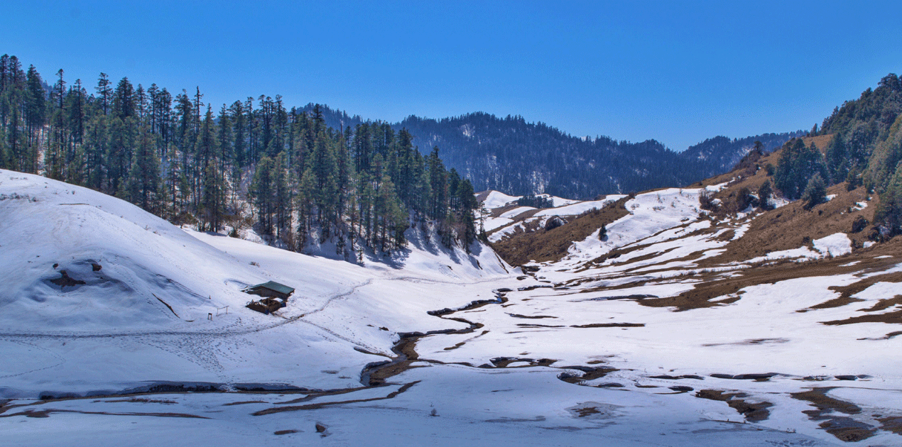
The Doti approach is the standard one. A road climbs from Silgadhi toward the park boundary and the walk in takes a day or so from the road head, depending on how far vehicles are getting that season. Inside the park is the ashram associated with Khaptad Baba, the ascetic who lived on the plateau for decades and whose presence is the reason a great many Nepali visitors come at all. The park detail is in our Khaptad National Park guide, and the spiritual side of the plateau in our piece on the Khaptad Baba ashram trek.
One planning note that catches people out. Khaptad is a summer destination in a country where summer is the wrong season for everything else. The plateau is under snow through the winter and the meadows are at their best from late spring through the early autumn, which puts the best months for Khaptad awkwardly close to the monsoon that makes the roads to Doti unreliable. Build slack in.
Doti at a glance
| Item | Detail |
|---|---|
| Province | Sudurpashchim Province |
| District headquarters | Dipayal Silgadhi: Dipayal on the Seti, Silgadhi on the ridge above |
| Area | Around 2,025 sq km |
| Terrain | Warm river terraces on the Seti rising to grassland around 3,000 m on the Khaptad boundary |
| Main river | The far-western Seti, which rises in Bajhang and joins the Karnali |
| Neighbours | Bajhang to the north, Achham to the east, Kailali to the south, Dadeldhura and Baitadi to the west |
| Protected area | Khaptad National Park, established 1984, roughly 225 sq km, shared with three neighbouring districts |
| Airstrip | Dipayal, with intermittent service; Dhangadhi is the dependable airport |
| From Dhangadhi | Most of a day by road |
| Best months | October to November and March to May for the district; late spring to early autumn for Khaptad |
How to reach Doti
Fly Kathmandu to Dhangadhi, then travel north through Attariya and up the Seti corridor to Dipayal, which is most of a day on the road. Buses and shared jeeps run daily and leave early. From Dadeldhura, where the far-western road network divides, Doti is a shorter run east.
Dipayal has an airstrip that takes small aircraft intermittently. It is a contingency, not a plan. Anyone coming from further east in the hills can reach Doti overland from Achham, and anyone heading north continues on toward Bajhang on rougher roads that depend heavily on the season.
The road surface on the Seti corridor is a mix of sealed sections and graded track, and the proportion changes year to year as work continues. Ask at the bus park in Dhangadhi or Attariya the day before rather than trusting any published estimate. Departures are early, often before dawn, and the popular services fill the previous evening. For the Khaptad leg specifically, the question that decides your day count is how far vehicles are getting toward the park boundary that season, and only somebody in Silgadhi that week can answer it.
What the district lives on
Doti is hill farming: maize, millet, wheat and potato on rain-fed terraces, with livestock moving up to the higher grazing in summer. Citrus and other fruit do well on the warm mid-slopes, and the same constraint applies here as everywhere in the far west, which is that growing the crop is easier than getting it to a market before it loses its value.
The other income is migration. Long-term work in India is a normal part of a household's economics across this district, and the pattern shapes who is at home in any given season. It is worth knowing because it explains both the remittance-built concrete houses among the older stone ones and the fact that a village in spring can look considerably emptier than its population figure suggests.
Culture, deuda and the Doteli year
Doti is the linguistic heartland of Doteli, part of the western Khas group that standard Nepali grew out of, and speakers of standard Nepali will follow the substance and miss a good deal of the texture. Gaura Parva in Bhadra is the far west's own festival, when women fast for the goddess Gaura and the evenings turn into deuda, the linked-arm circle dance with sung couplets traded between two groups.
Deuda is not performed for visitors here. If you hear it, a wedding or a fair is happening, and the right response is to stand at the edge and listen rather than to film it. Our guide to deuda dance in far-western Nepal explains what is actually going on in the verses. Alongside the mainstream Hindu calendar, the Masta tradition of territorial deities served by dhami oracles runs through the district as it does across the whole far west.
Where to stay and practical notes
Silgadhi has the better accommodation, simple hotels aimed at government staff and traders, and Dipayal has more of the same near the offices. Both are adequate for a night or two and neither is aimed at tourists. On the Khaptad route there are basic lodges and army and park posts, and inside the park you should assume you are carrying or arranging your own food.
Draw cash in Dhangadhi. Branches and ATMs exist in Dipayal and work often enough to be a bonus rather than a plan. Mobile coverage follows the road and the towns and thins fast on the climb toward Khaptad. A national park entry fee applies inside Khaptad; no restricted-area permit is required anywhere in the district, but carry a passport for checkpoints.
Honest framing: Doti is a good two or three days, most of it built around Silgadhi and the walk toward the plateau. It is the most easily reached of the far-western hill districts and the one where a traveller with limited time gets the most in return.
Frequently Asked Questions
Where is Doti district in Nepal?
Doti is in the middle of Sudurpashchim Province, on the far-western Seti river, with Bajhang to the north, Achham to the east, Kailali to the south and Dadeldhura and Baitadi to the west. Its headquarters is Dipayal Silgadhi.
What is the difference between Dipayal and Silgadhi?
They are the two halves of the district headquarters. Dipayal sits low on the Seti and holds the administrative offices. Silgadhi sits on the ridge above and holds the bazaar, the Shaileshwari temple and most of the accommodation.
How do you get to Khaptad National Park from Doti?
A road climbs from Silgadhi toward the park boundary, and the walk in takes about a day from the road head depending on how far vehicles reach that season. It is the shortest and best served of the four district approaches.
What was the Doti kingdom?
Doti was the successor state that emerged in the far west after the Khas Malla kingdom broke apart in the fourteenth century. Ruled by the Raika line, it held much of what is now Sudurpashchim until the Gorkhali conquest in the 1790s, and the Doteli language takes its name from it.
When is the best time to visit Doti?
October to November and March to May for the district itself. Khaptad is different: the plateau is under snow in winter and is at its best from late spring through early autumn, which overlaps awkwardly with the monsoon on the roads.
Is there an airport in Doti?
Dipayal has an airstrip that takes small aircraft intermittently, but it is not dependable enough to plan around. Dhangadhi, most of a day away by road, is the airport with daily flights from Kathmandu.
