Api, at 7,132 m in Darchula district, is the highest mountain in Sudurpashchim Province and in far western Nepal. Saipal, at 7,031 m in neighbouring Bajhang, is the second. Both sit inside or beside the Api Nampa Conservation Area, a 1,903 square kilometre protected area established in 2010. Neither receives more than a handful of trekking parties in a season, and in some years neither sees a climbing expedition at all.
These are not small mountains. Api is higher than anything in the Annapurna Sanctuary except the Annapurnas themselves, and it rises with unusual abruptness from valleys not far above 2,000 m, which makes the relief here as dramatic as anywhere in Nepal. The emptiness is a matter of logistics and habit rather than quality.
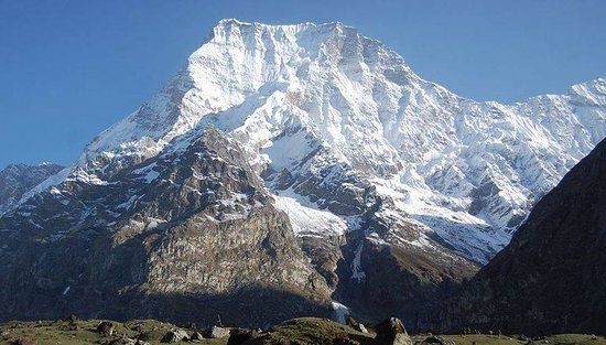
The two mountains
| Api | Saipal | |
|---|---|---|
| Height | 7,132 m | 7,031 m |
| District | Darchula | Bajhang |
| Range | Gurans Himal, far western Nepal | Saipal Himal, far western Nepal |
| First ascent | An Italian expedition, 1960 | A Japanese expedition, 1963 |
| Nearest road head | Darchula district headquarters at Khalanga | Bajhang district headquarters at Chainpur |
| Base camp trek | Roughly 10 to 14 days round trip | Roughly 14 to 18 days round trip |
| Accommodation on trek | Camping. No teahouse network | Camping. No teahouse network |
Nampa, the third peak of the group and the one that gives the conservation area half its name, rises just under 6,800 m on the ridge system east of Api. It is the mountain most visible from parts of the Darchula approach and is regularly mistaken for Api itself.
Api Nampa Conservation Area
The conservation area was gazetted in 2010 and covers 1,903 square kilometres of Darchula district, running from the Mahakali river on the Indian border up to the Tibetan frontier. The elevation range across it is enormous, from subtropical valley floor to the summit of Api, and the vegetation changes accordingly: sal and mixed broadleaf low down, then oak and rhododendron, then birch, then juniper scrub and alpine pasture.
The wildlife list includes snow leopard, Himalayan musk deer, Himalayan black bear, blue sheep and Himalayan tahr, with red panda in the temperate forest belt. Sightings of any of the cats are a matter of luck. What visitors actually notice is the plant diversity in the alpine meadows and the density of medicinal plant collection, which is a significant part of the local economy and a genuine pressure on the habitat.
Because the conservation area is managed rather than fully protected, people live and farm inside it, and the trekking routes pass through working villages rather than around them. Our guide to the Api Nampa and Gaurishankar conservation areas covers how that management model differs from a national park.
Getting to Darchula
This is the part that keeps the numbers down. Darchula is the far northwestern corner of Nepal, and Khalanga, the district headquarters, sits on the Mahakali river directly opposite Dharchula in India.
The realistic approach is to fly Kathmandu to Dhangadhi, which takes a little over an hour, then drive north. The road runs up through Attariya and Baitadi and takes the better part of a day, longer if the surface has been washed out. Doing it entirely overland from Kathmandu means two long days on the East-West Highway plus the drive north, which is why almost everyone flies the first leg.
From Khalanga the Api approach heads up the Chameliya valley to a road head, and the walking starts there. The Saipal approach starts from Chainpur in Bajhang, which is reached from Dhangadhi by a comparable drive, and climbs up the Seti valley towards the mountain. The West Seti rises in the Saipal massif, which is a neat way to understand the geography: the river you follow up is being made by the mountain you are walking towards.
What the treks are actually like
Both are camping treks. There is no lodge network in either valley, no established teahouse route, and no reliable resupply once you leave the road head. That means tents, a cook, porters or pack animals, and food carried in, which changes both the cost and the character compared with an Annapurna or Everest trek.
The Api base camp walk climbs from valley floors around 1,300 to 1,700 m to a base camp above 4,000 m below the northern face, passing through Chhetri and Thakuri farming villages lower down and Bhotiya settlements higher up. Ten to fourteen days round trip is normal, with the ascent profile steep enough that acclimatisation days are not optional.
Saipal base camp is longer and less travelled again, typically fourteen to eighteen days from Chainpur, following the Seti and its tributaries into high pasture. Very few operators run it as a scheduled departure, so in practice it is a private arrangement.
Neither is technically difficult walking. Both are long, remote and completely without infrastructure, which is a different kind of hard. There is no helicopter on standby and no clinic beyond the district headquarters, so parties need their own communications, their own first aid and a genuinely conservative plan.
Permits, and the one restricted corner
For the Api approach you need an Api Nampa Conservation Area entry permit, arranged through the National Trust for Nature Conservation or at the entry post, plus a TIMS card. That is the whole of it for the standard base camp route, and it is far simpler than the paperwork for Upper Dolpo or Humla.
There is one exception that catches people out. The northernmost part of Darchula, the Byas area running up towards the Tibetan border and the Tinkar valley, is a restricted zone. Going there requires a separate restricted-area permit, a registered agency and a licensed guide, on the same terms as Nepal's other restricted zones. The Api base camp route does not enter it, but a plan that drifts north of the mountain does, and finding that out at a checkpost is an expensive way to learn it.
Saipal is in Bajhang and needs no conservation area permit, since it lies outside the Api Nampa boundary, but the same practical rule applies: go with an agency, because there is nothing out there to fall back on.
Khalanga and the Mahakali
The district headquarters is worth a day in its own right, and most people passing through give it none. Khalanga sits on the Nepali bank of the Mahakali river directly opposite Dharchula in India, and the two towns are effectively one settlement divided by water, connected by a bridge that local people on both sides cross daily without much ceremony.
That makes it a good place to see how the far west actually functions. A great deal of trade, medical care and schooling for this corner of Nepal happens on the Indian side because it is closer than anywhere Nepali. Cash, mobile networks and prices all reflect that. There are simple hotels, a bazaar, a bank and the last reliable ATM before the mountains, and it is where any trek gets its final supplies.
Why almost nobody comes
Four reasons, and none of them is the mountains.
Distance from Kathmandu is the first: everything about a far west trip costs a day at each end that an Annapurna trip does not. The absence of teahouses is the second, and it roughly doubles the cost of a trek by requiring a full camping outfit. The third is that the trekking agency industry is concentrated in Kathmandu and Pokhara and sells the routes it knows, so far western itineraries are rarely on a website at all. The fourth is simple momentum: people go where other people have been, and there is very little written about these valleys.
The consequence is a Himalayan region with 7,000 m peaks, an established conservation area and functioning villages, receiving fewer trekkers in a year than Annapurna Base Camp takes in a busy week. Our Darchula district guide covers the wider district, and how to get to west Nepal sets out the flights, roads and permits.
When to go
The far west sits partly in the rain shadow but not as completely as Dolpa, so the monsoon does affect it. Autumn, from late September through November, gives the clearest air and the most settled weather, and is the season nearly everyone chooses. Spring, from April to early June, is warmer, hazier and better for rhododendron in the forest belt.
Winter closes the high approaches with snow and makes the passes serious. The monsoon brings leeches, landslides and roads that stop being roads. Our west Nepal seasons guide works through the regional differences, which are larger than most people expect. For the geology behind why these peaks stand where they do, see how the Himalayas formed. If the far west appeals but a camping expedition does not, Khaptad National Park is the accessible alternative in the same province.
Frequently Asked Questions
How high is Api Himal?
7,132 m. It is the highest mountain in Sudurpashchim Province and in far western Nepal, standing in Darchula district near the borders with India and Tibet.
How high is Saipal?
7,031 m, in Bajhang district. It is the second highest peak of far western Nepal and the source region of the West Seti river.
How do you get to Api base camp?
Fly Kathmandu to Dhangadhi, then drive north through Attariya and Baitadi to Khalanga in Darchula, which takes the better part of a day. From there the route follows the Chameliya valley to a road head and walks in. Allow ten to fourteen days round trip on foot.
Is the Saipal base camp trek possible without a guide?
In practice, no. There are no lodges, no marked route and no resupply, so the trek requires a full camping outfit with staff. Very few agencies offer it as a scheduled departure, so it is normally arranged privately.
What is the Api Nampa Conservation Area?
A protected area of 1,903 square kilometres established in 2010, covering Darchula district from the Mahakali river up to the Tibetan border. People live and farm inside it, and it holds snow leopard, musk deer, Himalayan black bear, blue sheep and red panda.
Are there teahouses on the far west trekking routes?
No. Neither the Api nor the Saipal approach has a teahouse network. Both are camping treks, which roughly doubles the cost compared with an equivalent Annapurna itinerary.
When were Api and Saipal first climbed?
Api was first climbed by an Italian expedition in 1960 and Saipal by a Japanese expedition in 1963. Both see very few expeditions in any given year, and in some seasons none at all.
What is the best season for trekking in far western Nepal?
Autumn, from late September to November, for the clearest air and most settled weather. Spring from April to early June is warmer and hazier but good for rhododendron. Winter snow closes the high ground and the monsoon makes the roads unreliable.