
The Annapurna massif is a mountain chain roughly 55 kilometres long in central Nepal, bounded by the Kali Gandaki gorge to the west and the Marsyangdi valley to the north and east. Its high point is Annapurna I at 8,091 metres, the tenth highest mountain on earth and the first eight-thousander ever climbed, reached on 3 June 1950 by Maurice Herzog and Louis Lachenal of a French expedition. The massif also contains six peaks above 7,000 metres, the Thorong La at 5,416 metres, and the Annapurna Sanctuary, a glacial basin ringed by summits with a single walking entrance.
What peaks make up the Annapurna massif?
The name Annapurna gets used loosely. Strictly it belongs to a numbered group of four summits running west to east, but in practice the massif is understood to include the outliers that share its glaciers and its skyline. Understanding which peak you are looking at makes the whole region legible, because the trekking routes are essentially routes between these mountains rather than up them.
| Peak | Elevation | Position in the massif | Note |
|---|---|---|---|
| Annapurna I | 8,091 m | Western end of the main ridge | First eight-thousander climbed, 1950; its south face is a landmark of Himalayan climbing |
| Annapurna II | 7,937 m | Eastern end of the chain | Dominates the view from the lower Marsyangdi and the Manang approach |
| Annapurna III | 7,555 m | Centre of the main ridge | Parent summit of the spur that carries Machapuchare |
| Annapurna IV | 7,525 m | Adjoins Annapurna II | Seen as a broad snow shoulder from Manang |
| Gangapurna | 7,455 m | Above Manang village | Its glacier and moraine lake sit directly below the Circuit trail |
| Annapurna South | 7,219 m | Southern rim of the Sanctuary | The peak most trekkers photograph from Ghandruk and Poon Hill |
| Tilicho Peak | 7,134 m | Northwest of the main ridge | Overlooks Tilicho Lake and the Mesokanto route to Jomsom |
| Machapuchare | 6,993 m | Southern spur | Closed to climbing; eastern gatepost of the Sanctuary |
| Hiunchuli | 6,441 m | Southern spur | Western gatepost of the Sanctuary entrance |
Why was Annapurna I the first eight-thousander to be climbed?
Partly accident. The 1950 French expedition arrived intending to attempt Dhaulagiri, spent weeks reconnoitring the approaches with maps that were close to useless, decided the mountain was beyond them that season and switched objectives. They found a line on the north face of Annapurna I very late in the pre-monsoon window and pushed it hard. Herzog and Lachenal reached the summit on 3 June 1950, and the descent cost both men fingers and toes to frostbite.
It mattered because it was the first. Everest was still unclimbed, Nepal had only recently opened to foreigners, and the ascent demonstrated that the 8,000 metre barrier was passable. Herzog’s account of the climb became one of the best-selling mountaineering books ever written and pulled a generation of European climbers toward the Himalaya.
The mountain has since acquired a much darker reputation. Annapurna I has long carried the worst ratio of deaths to summits among the eight-thousanders, driven by serac-threatened approach slopes and enormous avalanche-prone faces. The 1970 British ascent of the south face by Dougal Haston and Don Whillans, on Chris Bonington’s expedition, opened the era of big-wall climbing at altitude and confirmed how serious the mountain is from the Nepali side.
What is the Annapurna Sanctuary?
The Sanctuary is a glacial amphitheatre at the head of the Modi Khola, enclosed almost completely by the southern arc of the massif. Annapurna I, Annapurna South, Gangapurna, Hiunchuli and Machapuchare stand on its rim. The only breach in the wall is a narrow gorge between Machapuchare and Hiunchuli, which is why every trekker walks in by the same route and why the approach feels like entering a building rather than crossing a landscape.
Inside, the basin holds the South Annapurna Glacier and a floor of moraine at around 4,000 metres. Annapurna Base Camp sits at 4,130 metres, with lodges and a wide sweep of peaks that stand more than 3,500 metres above the camp. The Sanctuary receives heavy snow, and the gorge section between Deurali and Machapuchare Base Camp is a documented avalanche path in winter and spring.
The basin also carries local religious significance for the Gurung communities of the Modi Khola, and it has historically had customary rules about what may be brought inside. The whole area is protected within the Annapurna Conservation Area, gazetted in 1986 and managed by the National Trust for Nature Conservation. At roughly 7,600 square kilometres it is the largest protected area in Nepal and the model for community-managed conservation across the country.
What are the main passes and how hard are they?
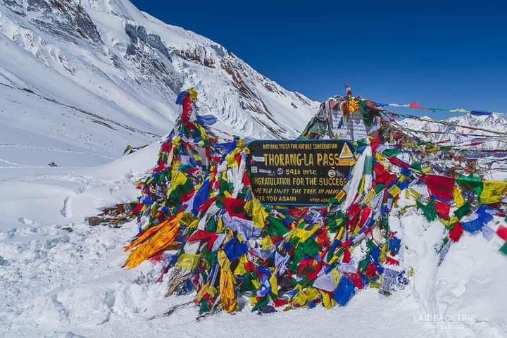
The Thorong La at 5,416 metres is the defining crossing of the Annapurna Circuit and the reason the route works as a loop. It links the Marsyangdi side at Manang to the Kali Gandaki side at Muktinath, and it is walked from east to west by almost everyone, because the ascent from Manang is gradual and the descent to Muktinath is brutally steep. Crossing in the other direction means gaining more than 1,600 metres in a single day at altitude.
The pass is a walk, not a climb, but it is a serious one. It is high enough that acute mountain sickness is a real risk for anyone who has rushed the approach, and it is exposed to wind and to sudden snow. The October 2014 storm that killed dozens of trekkers and workers on and around the Thorong La remains the reference case for why forecasts matter here.
Two other crossings are worth knowing. The Kang La at about 5,320 metres links the Nar Phu valley back to Manang and turns a restricted side valley into a loop. The Mesokanto La, west of Tilicho Lake at roughly 5,100 metres, drops to Jomsom and gives an alternative to the Thorong La for parties with camping support. Neither is a lodge route.
Which trek should you choose in the Annapurna region?
Four routes carry most of the traffic and they suit very different trips. The Annapurna Circuit is the long one, historically two to three weeks, running anticlockwise from the Marsyangdi through Manang, over the Thorong La and down the Kali Gandaki. Road construction on both sides has shortened the walking, and most parties now start higher and use the newer high trails to avoid the road.
The Annapurna Base Camp trek is shorter, usually seven to twelve days, and takes you inside the Sanctuary. It gains altitude fast at the end, which is its main risk. The Poon Hill loop is the short introduction, three to five days, topping out at 3,210 metres with a panorama from Dhaulagiri to Machapuchare. Mardi Himal, four to six days on the ridge below the Fishtail, is the quietest of the four and has the best close view of Machapuchare.
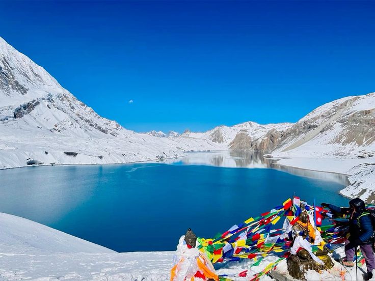
Add-ons change the character of a trip more than they change its length. Tilicho Lake, sitting at roughly 4,900 metres and often described as one of the highest lakes of its size in the world, adds two to three days to the Circuit and a genuine high camp. Nar Phu adds a restricted-area permit and two Tibetan-culture valleys that almost nobody visits. Both are worth the extra days if your acclimatisation allows.
Season is straightforward. October and November give the most stable weather and the clearest air. March to May is warmer, hazier and better for rhododendron forest. Winter closes the high passes intermittently and the monsoon, June to September, brings leeches and cloud everywhere except the rain shadow north of the main ridge.
FAQ
How high is Annapurna I?
Annapurna I is 8,091 metres, making it the tenth highest mountain in the world. It was the first peak above 8,000 metres to be climbed, on 3 June 1950, by Maurice Herzog and Louis Lachenal of a French expedition led by Herzog.
How many peaks over 7,000 metres are in the Annapurna massif?
Six summits in the massif exceed 7,000 metres: Annapurna II, Annapurna III, Annapurna IV, Gangapurna, Annapurna South and Tilicho Peak. Machapuchare at 6,993 metres and Hiunchuli at 6,441 metres are the best known of the sub-7,000 metre peaks.
How high is the Thorong La?
The Thorong La stands at 5,416 metres and is the high point of the Annapurna Circuit. It is normally crossed from east to west, from Thorong Phedi or High Camp down to Muktinath, because the ascent from that side is far more gradual.
Is the Annapurna Circuit ruined by roads?
It is changed rather than ruined. Vehicle roads now reach far up both the Marsyangdi and the Kali Gandaki, so most trekkers start higher and use the newer NATT high trails that keep walkers off the road for much of the route. The high section around the Thorong La is unaffected.
What permits do you need for the Annapurna region?
An Annapurna Conservation Area entry permit and current trekker registration are required for all routes, with an additional restricted-area permit for Nar Phu and Upper Mustang. Rules on guides and registration have changed repeatedly in recent years, so confirm the current requirements before you travel.