
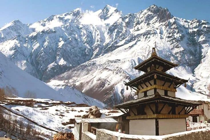
Muktinath is a temple complex at 3,710 m in Mustang district, Gandaki Province, on the eastern flank of the Kali Gandaki valley above the settlement of Ranipauwa. Hindus count it among the 108 Divya Desam shrines of Vishnu and come for release, which is what the name means. Tibetan Buddhists know the same courtyard as Chumig Gyatsa, the hundred waters.
One courtyard, two traditions, no argument
Shared sites are common in Nepal and usually involve some negotiation. Muktinath is unusual in that the sharing is complete and old. The pagoda-style main temple houses a Vishnu image and is attended by a Buddhist nun of the local tradition; pilgrims from Tamil Nadu and Gujarat walk the same circuit as Tibetan and Thakali families from the surrounding villages, and neither group treats the other as a visitor. If you want a single place that explains why Nepali religion resists tidy categories, this is it.
The 108 waterspouts and the two pools
Behind the main temple, a curved stone wall carries 108 brass spouts shaped as bulls' heads, each running glacial meltwater diverted from the stream above. Pilgrims strip to a minimum and run the full line, taking the water on the head at every spout, then immerse themselves in the two kunda pools in front of the temple. The water comes off ice at 3,710 m and the air in the courtyard is thin and often below freezing in the early morning. People do it anyway, at speed, and the noise of it carries across the compound. Bring a towel and dry clothes if you intend to join in; there is no shelter and nowhere warm.
Jwala Mai and the flame on water
A short walk below the main temple, the small Jwala Mai shrine encloses a natural gas seep. A flame burns in a recess in the rock beside, and at times apparently over, a trickle of spring water. The combination of fire and water in one place is what both traditions consider miraculous, and it is also a straightforward geological phenomenon: methane migrating up through fractured rock and igniting at the surface. The flame is small, it is behind a grille and in a dark room, and it changes over time. Ask the attendant before photographing it.
Muktinath at a glance
| Detail | Muktinath |
|---|---|
| District | Mustang |
| Province | Gandaki |
| Elevation | 3,710 m |
| Waterspouts | 108, in the form of bulls' heads |
| Hindu status | One of the 108 Divya Desam shrines of Vishnu |
| Buddhist name | Chumig Gyatsa |
| Nearest airstrip | Jomsom |
| Jomsom to Muktinath | Roughly 1.5 hours by jeep |
| Base settlement | Ranipauwa, a short climb below the gate |
| Permits | Annapurna Conservation Area entry permit; restricted-area permit not required |
Getting there: fly, drive, or walk over the pass
The quickest way in is the short flight from Pokhara to Jomsom. It is scheduled in the early morning because the Kali Gandaki wind gets up predictably before midday and the strip closes to arrivals; the flight itself lasts well under half an hour. Cancellations for weather are routine, so do not plan a tight connection out of Pokhara the same evening.
By road, jeeps run from Pokhara through Beni and up the Kali Gandaki to Jomsom in a long, rough day, and from Jomsom to Ranipauwa in about an hour and a half. The road is unsealed for long stretches, exposed in places, and closed by landslides after heavy rain. Buses run the lower sections.
The third arrival is on foot from the north, descending from the Thorong La at 5,416 m, which is how trekkers on the Annapurna Circuit reach the temple. Arriving that way, after a pass day, is the version most people remember.
Permits: what you need and what you do not
Muktinath lies inside the Annapurna Conservation Area, so an ACAP entry permit is required and is checked at Jomsom. A TIMS card is normally taken as well for trekkers. What is not required is a restricted-area permit: those apply north of Kagbeni, in Upper Mustang, which is a separate and far more expensive proposition. A good many visitors budget for the restricted permit unnecessarily. Fees for all of these are set by the authorities and change, so check the current rate rather than a figure from a blog; our guide to restricted-area permits explains how the system is structured and where the boundaries fall, and the Annapurna Conservation Area guide covers the ACAP side.
3,710 m is high enough to hurt you
This is the risk that pilgrimage traffic underestimates, because flying from Pokhara at around 800 m to Jomsom at around 2,700 m and driving straight up to 3,710 m compresses into a few hours an ascent that a trekker takes days over. Headache, nausea and broken sleep are common at Ranipauwa. Older pilgrims in large groups are the population most often affected, and the standard mistakes are arriving and immediately climbing to the temple, and dismissing symptoms as travel fatigue.
Sleep at Jomsom or Kagbeni first if the schedule allows, drink more than feels necessary, go up slowly and descend if symptoms worsen. Our altitude sickness and acclimatisation guide covers the warning signs and the thresholds at which going down stops being optional.
Ranipauwa, and the last twenty minutes
Vehicles stop at Ranipauwa, a strip of lodges, teashops and pilgrim hostels below the temple. From there it is a walk of fifteen to twenty-five minutes up a stone path and steps to the gate, through a line of stalls selling shawls, prayer flags and shaligram stones from the riverbed. Ponies and, in season, motorbikes can be hired for the climb, which is what most elderly pilgrims use. The gate has opening hours; arriving at first light means cold air, an empty courtyard and the best light on the Dhaulagiri wall across the valley.
When to come
Mustang sits in the rain shadow behind the main Himalayan range, so it stays comparatively dry through the monsoon and remains reachable when much of Nepal is under cloud. That makes June to September a genuine option here, unlike almost anywhere else in the country. Winter from December to February is cold, the pools freeze at the edges and heavy snow can close the road or the pass for days. March to May and October to November are the busiest and most comfortable. Fuller background on the temple itself is in our complete Muktinath guide, and if you are continuing north, Upper Mustang begins at the Kagbeni checkpost.
Frequently Asked Questions
How far is the walk up from Ranipauwa?
Fifteen to twenty-five minutes on a stone path and steps from where the vehicles stop, through a line of stalls. Ponies and, in season, motorbikes can be hired for the climb, which is what most elderly pilgrims use.
Do I need a restricted-area permit for Muktinath?
No. Muktinath sits inside the Annapurna Conservation Area and needs an ACAP entry permit. Restricted-area permits apply north of Kagbeni, in Upper Mustang, which is a separate arrangement.
Is it better to fly to Jomsom or drive from Pokhara?
Flying is far quicker: an early-morning flight, then about an hour and a half by jeep from Jomsom. The road through Beni takes a long, rough day. Flights are cancelled for wind often enough that the road is the reliable option and the flight is only the fast one.
Can I visit Muktinath during the monsoon?
Yes, more reliably than most of Nepal. Mustang lies in the rain shadow of the main range and stays comparatively dry from June to September, although the approach road below Jomsom is still exposed to landslides.
What do I need if I want to bathe at the spouts?
A towel and a full change of dry clothes, and somewhere to leave them. Pilgrims pass beneath every spout in turn and then immerse in the two pools; the water comes straight off ice, the courtyard is often below freezing early on, and there is no shelter and nowhere warm.
Is altitude sickness a real risk here?
Yes. Arriving by air and jeep gains a great deal of height in a few hours with no acclimatisation, and headaches and nausea are common at Ranipauwa. Sleep lower first if you can, ascend slowly and go down if symptoms get worse.