
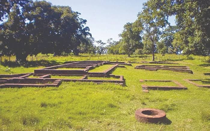
Tilaurakot is a walled archaeological site in Kapilvastu district, Lumbini Province, roughly 27 km west of Lumbini. Most archaeologists identify it as Kapilavastu, the Shakya capital where Siddhartha Gautama lived until he was twenty-nine. What survives above ground is an earth rampart, a moat line, two gateways and a grid of brick foundations.
Why archaeologists think this is Kapilavastu
The identification rests on two Chinese pilgrims. Faxian in the fifth century and Xuanzang in the seventh both walked this stretch of the Terai and left itineraries giving distances and directions between Lumbini, Kapilavastu and the smaller Shakya towns. Purna Chandra Mukherji, surveying for the Archaeological Survey of India in 1899, matched those bearings to the mound at Tilaurakot and made the case that has held ever since.
It is not unanimous. A rival site at Piprahwa, a short distance across the border in Uttar Pradesh, produced a reliquary inscription naming the Shakyas, and a body of Indian scholarship argues that Piprahwa is the real Kapilavastu. The Nepali case is strongest on urban form: Tilaurakot is a fortified town of the right period and the right scale, and the surrounding Shakya sites fall roughly where the pilgrims said they would. The argument has run for more than a century and no signboard is going to settle it. Say so to your guide and you will usually get a better conversation than the standard tour.
Digging has been intermittent since Mukherji. Nepal's Department of Archaeology, a Japanese team from Rissho University and, more recently, a joint programme with Durham University have all worked here, and the modern seasons have pushed the occupation sequence back into the first millennium BCE. Tilaurakot sits on Nepal's UNESCO Tentative List and has been prepared for full nomination for years, which is why the site is fenced, mapped and reasonably well looked after by Terai standards. If you want the wider picture of how Nepal manages this kind of place, our guide to Nepal's UNESCO World Heritage sites sets out the difference between the inscribed list and the tentative one.
What you actually see on the ground
Do not arrive expecting standing architecture. Tilaurakot is a low rectangular platform in farmland, bounded by an earth rampart that still reads clearly on the eastern and western sides, with a shallow depression outside it where the moat was. Two gateways have been exposed and consolidated. Inside, brick wall stubs mark out courtyards, drains and what excavators have interpreted as a palace complex.
The eastern gateway is the one to stand at. Tradition holds that this is the gate Siddhartha rode out of when he left the city, and whatever you make of that, the sightline east towards Lumbini is the reason the identification works at all. Allow an hour to walk the enclosure properly and another half hour for the small site museum, which holds coins, pottery and terracotta figurines pulled out of the mound.
Bring water and a hat. There is almost no shade inside the rampart, the site is unroofed, and between April and June the Terai heat here is punishing. Signage is sparse and mostly in Nepali. A local guide from Taulihawa bazaar costs very little and is worth it, because without one the mounds read as mounds.
The other Shakya sites within an hour
Tilaurakot on its own is a short visit. Treated as the centre of a cluster it becomes a proper day. Kudan, a few kilometres south, is where the Buddha is said to have met his father after his enlightenment, and holds three substantial brick monuments. Gotihawa has the broken shaft of an Ashokan pillar beside a stupa mound, marking the traditional birthplace of an earlier Buddha, Krakuchhanda. Niglihawa has another Ashokan pillar, cracked and lying at an angle, carrying an inscription that records Ashoka's visit.
Sagarhawa and Araurakot are quieter still and only worth it if you are genuinely interested. The Ashokan pillars matter beyond Buddhism: they are among the oldest datable written objects in the country, and they anchor the chronology that later Nepali history is measured against. Our overview of the Licchavi period picks up the story several centuries after these stones were cut, and the guide to Nepal's 77 districts explains where Kapilvastu sits in the current administrative map.
Getting there, and when to go
Almost everyone comes from Lumbini, which is about 27 km east on a sealed road and takes forty-five minutes to an hour by taxi or hired car. Public buses run to Taulihawa, the district headquarters three kilometres from the site, but they are slow and the last leg still needs a rickshaw or a short walk. The nearest airport is Gautam Buddha International at Bhairahawa, with domestic flights from Kathmandu and a handful of international services.
October to March is the sensible window: dry, clear and cool enough to walk an unshaded site. December and January mornings can be lost to Terai fog, which does not stop the visit but does flatten the photographs. April and May are hot, and the monsoon from June to September turns the surrounding fields to mud and the light to grey.
There is no reason to stay overnight in Taulihawa. Base yourself in Lumbini, where the monastic zone has accommodation at every price point, and treat Tilaurakot as a half-day trip. If Lumbini itself is on your list, the Lumbini destination page covers the Maya Devi temple and the monastic zone, and our guide to Nepal's major temples puts both sites in the wider pilgrimage picture.
| Detail | Tilaurakot |
|---|---|
| District | Kapilvastu |
| Province | Lumbini |
| Nearest town | Taulihawa, about 3 km |
| Distance from Lumbini | About 27 km, 45 to 60 minutes by road |
| Nearest airport | Gautam Buddha International, Bhairahawa |
| Site type | Fortified early historic town, rampart and moat |
| UNESCO status | On Nepal's Tentative List, not yet inscribed |
| Best season | October to March |
| Time needed | 1 to 2 hours, or a half day with the outlying sites |
Is it worth the detour
Honestly, it depends on what you came for. If you want atmosphere and architecture, Lumbini and Bhaktapur will give you more in an afternoon. If you are interested in how a religion's founding story gets tied to a physical place, Tilaurakot is one of the most interesting sites in South Asia, precisely because the tying is still contested and still being excavated. Visitor numbers are low, there is rarely anyone else inside the rampart, and the quiet is part of the point. Anyone planning a slower route through the Terai will find our notes on travelling Nepal with fewer stops useful for building a week around it.
Frequently Asked Questions
Is Tilaurakot the same place as Lumbini?
No. Lumbini is where the Buddha was born and is an inscribed UNESCO World Heritage Site. Tilaurakot, about 27 km west, is the city where he grew up. They are separate sites with separate entrances and are usually combined into one trip.
How long does a visit take?
One to two hours covers the rampart, the gateways, the excavated foundations and the small museum. Add the outlying Shakya sites at Kudan, Gotihawa and Niglihawa and it becomes a comfortable half day.
Is there an entry fee?
Yes, a modest ticket is sold at the entrance, with separate rates for Nepali, SAARC and other foreign visitors, as at most Department of Archaeology sites. Carry small notes in Nepali rupees, as card payment is not available.
Do I need a guide?
Not required, but strongly recommended. Interpretation on site is thin, and without someone to explain what each mound represents the visit is a walk around a field. Guides can be arranged in Taulihawa or through hotels in Lumbini.
What is the best time of year to visit?
October to March. The site is unshaded, so April to June is uncomfortably hot, and the monsoon between June and September makes the approach roads and the field paths messy.
How do I get there without a car?
Take a local bus from Lumbini or Bhairahawa to Taulihawa, then a rickshaw or a twenty-minute walk to the site. It works, but a shared taxi from Lumbini costs little more and saves several hours.