
Nepal's political centre moved from the Karnali to the Kathmandu valley between the fourteenth and eighteenth centuries. Four things drove it: the valley grew far more food per hectare, it sat on the shortest trade corridor between India and Tibet, its kings minted Tibet's coinage for a fee, and the Khas Malla succession fractured while the valley's dynasties did not.
This is the question underneath most of what this site writes about. Why is western Nepal the poorest, least visited and least invested-in part of the country, when it held the strongest state in the Himalaya for two hundred years? The answer is not that the west declined. It is that the east had structural advantages the west could not match, and that once the gap opened it was widened deliberately for another two centuries.
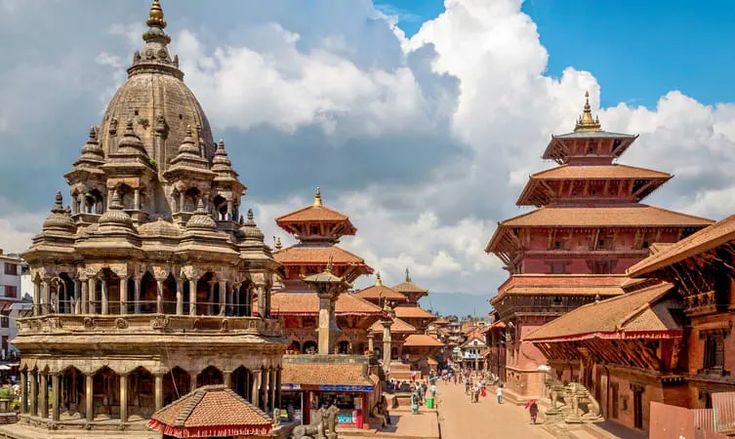
The Two Centres, Side by Side
| Sinja and the upper Karnali | The Kathmandu valley | |
|---|---|---|
| Elevation of the main settlement | Around 2,400 to 2,500 m | Around 1,300 to 1,400 m |
| Cultivable ground | Narrow valley floors between steep slopes | Roughly 650 sq km of level former lake bed |
| Crops in a year | One main crop; two only on the best land | Two, and three on irrigated ground |
| Staples | Barley, buckwheat, millet, potato; rice at the limit of where rice will grow | Rice, wheat, vegetables |
| Winter | Snow closes the passes for months | Frost, no closure |
| Route to Tibet | High and seasonal, through Humla and Mugu | Kuti and Kerung, shorter and open most of the year |
| Route to the Indian plains | Days of ridge walking down to the Bheri and the Rapti | A short descent to the Tarai and the Ganges trade towns |
Read down that table and the outcome stops looking like an accident.
Why the Karnali Could Not Feed a Capital
A capital is a concentration of people who do not grow food: soldiers, officials, priests, craftsmen, traders. Sustaining one requires a farmed surplus within carrying distance, and carrying distance in the Nepali hills before roads meant what a person could walk in a day or two with a loaded doko.
The upper Karnali cannot produce that surplus. The valley floors are narrow, the slopes above them are steep and thin-soiled, the growing season is short, and the altitude puts most of the district above the comfortable range for rice. Jumla grows the red Marshi rice at around 2,300 to 3,000 metres and it is famous precisely because it is exceptional: this is often described as the highest rice cultivation anywhere in the world, which is another way of saying it is at the outer edge of what is agronomically possible.
The Kathmandu valley is the opposite case. It is the bed of a former lake, which means deep level soil across hundreds of square kilometres at an altitude warm enough for rice and cool enough to avoid the worst of the lowland diseases. Three cities could sit in it, feed themselves, support full-time artisan populations and still export. No comparable basin exists anywhere in western Nepal.
The Khas Malla state solved the problem the only way available: it was not concentrated. Its power ran along trade routes and through tributaries across a wide area rather than out from a dense capital. That works well while the routes are profitable, and fails completely when they are not.
The Trade Corridor That Moved
The Khas Malla economy rested on the trans-Himalayan exchange: salt and wool south from the Tibetan plateau, grain and manufactured goods north. Our article on the salt trade routes describes how that traffic worked and what it built in Humla, Mugu and Dolpa.
The western routes have one permanent disadvantage. They are higher, longer and open for fewer months than the central ones. A caravan from the Indian plains to Lhasa via Humla crosses far more difficult ground than one via the Kathmandu valley and the Kuti or Kerung passes. As Indo-Tibetan trade grew in volume through the medieval period, and as the demand in Lhasa shifted from local exchange toward manufactured and luxury goods coming up from India, the advantage of the shorter central corridor compounded.
This is a case where geography does not change but its value does. The Karnali passes were exactly as high in 1200 as in 1600. What changed was the size and the composition of the trade that had a choice of routes, and the choice went east.
Kathmandu Minted Tibet's Money
The single most underrated factor is a coinage arrangement. For a long period the Malla kings of the Kathmandu valley supplied Tibet with its silver currency: Tibet sent silver bullion south, the valley mints struck it into coin, and the valley kept a share. It was an extraordinary source of revenue for three small city-states, and it explains a great deal of the metalworking, temple building and craft wealth visible in the durbar squares today.
It also explains why the three valley kingdoms fought each other so bitterly over something as apparently technical as coin purity. A dispute over debased coinage supplied to Tibet ran for generations and did real damage to the arrangement. Our article on the Malla dynasty and the three kingdoms covers that rivalry.
The Karnali had no equivalent. It had transit trade, which is valuable, and no monetary franchise at all. A state that takes a cut of every coin circulating in a neighbouring country is in a different financial category from one that taxes passing caravans.
Why the Khas Malla Succession Fractured
Structural advantages explain the trend. They do not explain the timing, and the timing was a succession failure.
The Khas Malla kingdom came apart in the fourteenth century through internal division rather than external conquest. Territory was split between claimants, tributaries used the opportunity to stop being tributaries, and what had been one state became the cluster of small principalities described in our article on the Baise and Chaubise rajya. None of the successors was large enough to re-concentrate the whole.
The Kathmandu valley went through something that looks similar and had the opposite result. It split into three kingdoms, Kathmandu, Patan and Bhaktapur, which fought each other for centuries. But all three sat in the same fertile basin, within a day's walk of one another, competing for the same trade and the same craftsmen. The competition drove investment: each city built more, patronised more artists and maintained more infrastructure than any of them would have alone. Fragmentation in a rich basin produced three wealthy cities. Fragmentation across the Karnali produced twenty-two poor ones.
What the Climate Argument Adds, and What It Does Not
Some accounts add a climatic factor: a cooling period across the northern hemisphere in the later medieval centuries would have pushed the upper limit of viable agriculture downhill, and the upper Karnali farms close to that limit. On this reading, marginal high settlements became unviable and the whole system contracted.
It is plausible and it is not settled. The chronology of climatic cooling in the Himalaya is itself debated, the archaeological record from the Karnali is thin, and the argument is difficult to separate from the trade and succession explanations, which act at the same time and in the same direction. It is worth knowing about, and it should not be quoted as the cause. The trade shift and the succession failure are much better evidenced.
What the West Lost, and When
The losses came in three waves, and the last one is recent enough to be the reason western Nepal looks the way it does now.
The first was political. When Gorkha took Jumla in 1789 and Doti in 1790, the western hills went from being a set of self-governing states to being distant districts administered from a capital fifteen days' walk away.
The second was administrative. The Rana century concentrated everything in Kathmandu: revenue, appointments, the army, what education existed, and eventually the first roads and the first industry. Distance from Kathmandu became the single best predictor of how much of anything a district received, and the Karnali is as far from Kathmandu as Nepali territory gets.
The third was infrastructural, and it is the one people underestimate. Nepal's road network was built outward from the centre from the 1950s. The east and the central hills were connected decades before the Karnali. The Karnali Highway from Surkhet north through Kalikot to Jumla is a recent link and remains a long, rough journey that varies with the season. Simikot, the headquarters of Humla, is still reached by air. A district that gets its road access two generations after the rest of the country does not catch up; it loses those two generations of schooling, trade, health provision and investment, and the people who could leave, left. Seasonal labour migration to India became the cash economy of the western hills, which is what our Jumla and Kalikot guides describe on the ground.
What Federalism Changed After 2015
The 2015 constitution created seven provinces, and Karnali is one of them, with its own government seated at Birendranagar in Surkhet. That is the first time since 1789 that the Karnali basin has had an administrative centre inside it with a budget of its own.
What it has not done is reverse the arithmetic. Karnali remains the province with the lowest development indicators in the country, and a provincial capital does not build a road network. But it changes where decisions about the Karnali are taken, which is not nothing, and it is the first structural change in the direction of travel in two hundred years.
The reason to visit Sinja is not that anything dramatic is standing there. It is that the valley is the clearest place in Nepal to see what a centre of power looks like once the reasons for it have moved somewhere else.
Frequently Asked Questions
Where was the capital of the Khas Malla kingdom?
The Sinja valley, in what is now Jumla district in Karnali Province. It was the seat of a kingdom that controlled much of the western Himalaya and reached into western Tibet from roughly the twelfth to the fourteenth centuries.
Why did the Khas Malla kingdom decline?
A succession failure in the fourteenth century split it between claimants, and the trans-Himalayan trade that funded it was shifting to shorter central routes. Neither cause alone would have been decisive; together they left successor states too small to rebuild the whole.
Why did Kathmandu become the capital of Nepal?
Because it was the richest place in the hills. The valley is a former lake bed with hundreds of square kilometres of deep level soil at a rice-growing altitude, it sat on the shortest India to Tibet trade corridor, and its kings earned revenue minting Tibet's silver coinage. Gorkha took it in 1768 and kept the capital there.
Did the Kathmandu valley kings really mint Tibet's currency?
Yes. For a long period Tibet sent silver south to be struck into coin in the valley mints, with the valley retaining a share. Disputes over the purity of that coinage were a serious source of conflict between the three valley kingdoms.
What is Marshi rice?
A red rice grown in Jumla at roughly 2,300 to 3,000 metres, often described as the highest rice cultivation in the world. It is notable because it is at the outer edge of where rice will grow, which is exactly the constraint that limited how large a population the upper Karnali could support.
When did Karnali get road access?
Very late. The Karnali Highway running north from Surkhet through Kalikot to Jumla is a recent connection and remains a long, rough journey that varies with the season. Simikot, the district headquarters of Humla, is still reached by air.
What did federalism change for Karnali?
The 2015 constitution made Karnali one of seven provinces, with a government seated at Birendranagar in Surkhet. It is the first administrative centre inside the Karnali basin since 1789, although it has not yet changed the province's position at the bottom of Nepal's development indicators.
Can you visit Sinja valley today?
Yes, on foot from Jumla, usually combined with a Jumla-based itinerary or a trip to Rara. There is little standing architecture; the interest is the inscribed stones, the setting and the fact that this valley was the political centre of the western Himalaya.