
Jumla grows rice at an altitude where rice should not grow. The red marsi paddy planted in the Tila valley and the side valleys above it is widely described as the highest rice cultivation in the world, ripening at elevations that would be tree line in most of the Himalaya. It is a small crop by national standards and it will never feed anyone outside the district. But it tells you what Jumla is: a high, cold, self-contained basin that has been farmed intensively for a very long time.
That length of settlement is the second thing to understand. Long before Kathmandu mattered to anyone in the far west, Jumla and the valleys around it were the political centre of a kingdom that ran from the Karnali across into what is now western Tibet. Modern Jumla can look like a remote district headquarters with an airstrip and a bazaar. It is actually one of the oldest continuously important places in the Nepali Himalaya.
Why Jumla mattered: the Khas Malla centuries
Between roughly the twelfth and fourteenth centuries the Khas Malla kingdom controlled a large part of the western Himalaya from a base in this part of the Karnali. Its summer capital lay in the Sinja valley, a day or so northwest of the modern Jumla bazaar, and its winter capital at Dullu in what is now Dailekh. From there the dynasty projected authority over trade routes to Tibet, over the middle hills, and for a period across a wide stretch of the Nepali west.
What that kingdom left behind is not architecture on the scale of the Kathmandu Valley. It is stone: inscribed pillars, temple foundations, carved slabs standing in fields. It is also language, which is the more consequential inheritance. The Khas speech of these valleys is the direct ancestor of modern Nepali, and the earliest inscriptions in that language come from this corner of the country. Our longer treatment of the dynasty is at the Khas Malla kingdom of west Nepal.
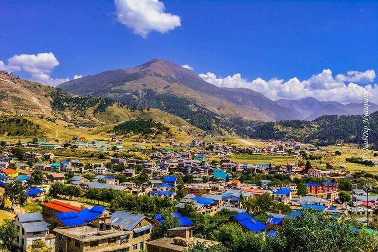
The shape of the land: the Tila valley and the ridges above
Jumla is a district of one main valley and a great many side ones. The Tila river runs west through the middle of it, and the district headquarters at Khalanga sits on the valley floor at around 2,500 m. That is high for a permanent bazaar town in Nepal, and it shows: winters are hard, snow closes the passes, and the vegetation is pine and spruce rather than the subtropical growth of the middle hills.
Above the valley the land rises through forest into open grazing country, the patan grasslands where herders bring livestock in summer. Higher still are the collection grounds for yarsagumba and for the medicinal herbs that have been traded out of these hills for centuries. The pattern is a vertical one. Households do not simply live at one altitude, they use several across the year, moving animals and labour up and down the slope as the season allows.
| Elevation band | Landscape | What happens there |
|---|---|---|
| Around 2,300 to 2,600 m | Tila valley floor, terraced and irrigated | Khalanga bazaar, the airstrip, paddy fields, apple orchards |
| 2,600 to 3,000 m | Upper terraces and mixed forest | The upper limit of marsi rice; walnut, buckwheat, barley and potato |
| 3,000 to 3,500 m | Blue pine, spruce and birch | Timber, winter fodder collection, scattered seasonal settlement |
| 3,500 to 4,000 m | Open patan grassland above tree line | Summer grazing camps for sheep, goats and cattle |
| Above 4,000 m | Alpine slope, snow into early summer | Yarsagumba and herb collection, high passes on the walking routes north |
Marsi rice, Jumli apples and the district economy
Marsi is a red, short-grain, cold-tolerant rice found nowhere else in Nepal at this altitude. Yields are low and the growing season is short, so it has never been a commercial crop. Locally it carries real weight: it appears at weddings and festivals, it is the rice people give as a gift, and there has been sustained effort in recent years to register and protect it as a distinctive product of the district.
Apples are the other Jumla crop with a reputation beyond the district. The cold winters and dry, bright autumns produce fruit that keeps well, and orchards have expanded steadily since the government first promoted them here decades ago. The persistent problem is not growing the apples but moving them. A crop that ripens in a district connected by one rough highway and one small airstrip loses much of its value in transit, and improving that link has been a policy argument in Karnali for as long as the orchards have existed.
Culture: Chandannath, Deuda and the Karnali year
The Chandannath temple above Khalanga is the ritual centre of the district and gives the main town its older name. Its festivals draw people in from the surrounding valleys, and the temple complex is the natural first stop for any visitor with an interest in how Shaiva practice in the Karnali differs from the version seen in Kathmandu. A dedicated guide is at the Chandannath temple in Jumla.
The other thing worth arriving in time for is Deuda. The circle dance and its call-and-response singing are the living cultural form of the Karnali and the far west, performed at fairs, weddings and festivals, and the lyrics carry a great deal of local history that never made it into any written record. If a fair is happening while you are in the district, change your plans and go.
Using Jumla as a base for Rara and Sinja
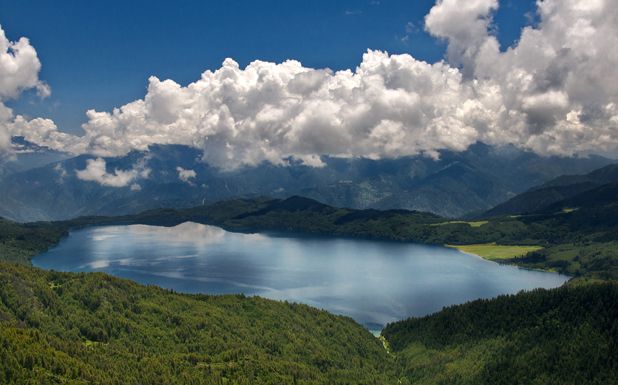
For most travellers Jumla is a beginning rather than a destination. The classic walk from here goes north over forested ridges and open grassland to Rara Lake in Mugu, a route of several days that passes through villages with almost no tourist infrastructure and some of the finest walking country in western Nepal. Road access to Rara has improved and many visitors now drive, but the walk remains the better experience by a wide margin.
West of the bazaar lies Sinja, the old summer capital, reachable in a long day or a comfortable two. Going there after seeing Chandannath makes the history legible in a way that reading about it does not. Further afield, Jumla connects south to the Karnali Highway and onward to Surkhet, and it is a plausible node in a longer circuit through the province.
Practical information for travellers
Flights link Jumla to Nepalgunj and are the fastest way in, though as everywhere in the Karnali they depend on weather. By road, the Karnali Highway runs up from Surkhet through Kalikot, and the journey is long, rough and best treated as a full day at minimum. Accommodation in Khalanga is basic guesthouse standard and adequate; outside the bazaar, expect homestay or nothing.
Come between April and October. Winter is genuinely cold at this altitude and the higher routes north can be blocked by snow well into spring. Autumn is the most reliable stretch for both weather and views, and it also coincides with harvest, which is the district at its most photogenic. See our destination page on Jumla for what to see once you are there.
FAQ
How do you get to Jumla from Kathmandu?
Fly to Nepalgunj and take a connecting flight to Jumla, or travel by road via Surkhet and the Karnali Highway. The road route is long and rough, and the flight is far quicker when the weather cooperates.
Why is Jumla famous for rice?
Jumla grows marsi, a red cold-tolerant paddy, at an altitude generally described as the highest rice cultivation in the world. Yields are small but the crop has strong cultural and ceremonial importance in the district.
Can you walk from Jumla to Rara Lake?
Yes. The walk north to Rara takes several days through forest, grassland and small villages, and it remains the most rewarding way to reach the lake even though a road now also serves it.
Do you need a permit for Jumla?
Jumla itself is not a restricted area, so no special permit is required for the district. A national park entry permit applies if you continue into Rara National Park.
What is the best time to visit Jumla?
April to October. Autumn gives the clearest weather and coincides with harvest, while winter is very cold and can close the higher routes with snow.