
Rupandehi is a Tarai district in Lumbini Province, southern Nepal, on the Indian border. It contains Lumbini, the birthplace of the Buddha and a UNESCO World Heritage Site, along with Butwal, the largest city in the province, and Siddharthanagar, also called Bhairahawa, which is the district headquarters and the site of Gautam Buddha International Airport.
This is the busiest and most-visited district in the province by a very wide margin, and most of the visitors are there for one thing. Lumbini receives pilgrims from across the Buddhist world, tour groups from India crossing at Sunauli, and a steady flow of independent travellers using it as a stop between Kathmandu, Pokhara and Varanasi. The district around it is a working Tarai economy that almost nobody stops to look at, which is a fair enough choice but means missing Butwal and Devdaha entirely.
Where is Lumbini?
Lumbini is in Rupandehi district, in Lumbini Province, in the southern Tarai plain of Nepal, roughly 22 kilometres west of Bhairahawa and about 25 kilometres north of the Indian border at Sunauli. It is not in India, and it is not near Kathmandu: the capital is around 280 kilometres away by road, which is eight to nine hours of driving.
The confusion is understandable, because three different things carry the name. Lumbini is the sacred site itself. Lumbini Sanskritik Municipality is the local government unit around it. Lumbini Province is one of Nepal's seven provinces, covering twelve districts including this one. If a booking, a map or a bus ticket says Lumbini, check which of the three is meant.
The nearest airport is Gautam Buddha International Airport at Bhairahawa, about half an hour away by road. The nearest border crossing is Belahiya, on the Nepali side of what most people call Sunauli, with Gorakhpur in Uttar Pradesh roughly 100 kilometres beyond it.
The sacred site
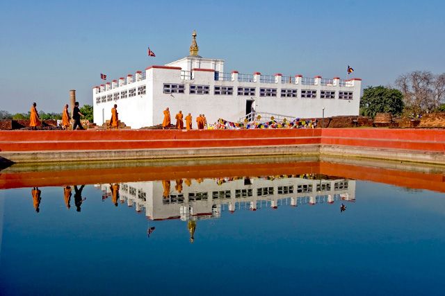
The Maya Devi Temple stands at the centre of the sacred garden and encloses the excavated remains identified as the birthplace, including a marker stone taken to indicate the exact spot. Beside it is the Ashokan pillar, raised by the Mauryan emperor Ashoka in 249 BCE during his visit, carrying an inscription that names the site as the Buddha's birthplace. That pillar is the reason Lumbini can be located at all: it is the oldest firmly dated monument in Nepal and the primary evidence connecting the archaeology to the tradition.
Around the temple are the Puskarini, the pond where Maya Devi is said to have bathed before the birth, the brick foundations of monasteries and stupas from across many centuries, and a large bodhi tree hung with prayer flags. The site was inscribed on the UNESCO World Heritage List in 1997.
The wider Lumbini Development Zone was laid out under a master plan drawn up by the Japanese architect Kenzo Tange in 1978, and it is much larger than most visitors expect: a long central canal running north from the sacred garden, with monastic zones on either side where Buddhist countries and traditions have each built a monastery in their own architectural style. Walking or cycling between the Thai, Myanmar, Korean, German and Chinese monasteries takes most of a day and is the part of the visit people remember. The World Peace Pagoda sits at the northern end.
How long to spend and how to see it
A day covers the sacred garden and a handful of monasteries. Two days lets you do it properly, with an early morning at the Maya Devi Temple before the coach parties arrive and a slow afternoon on a hired bicycle through the monastic zone. The distances inside the development zone are too long to walk comfortably in the heat, and bicycles and electric rickshaws are both easy to hire at the gate.
Dress modestly, remove shoes where required, and expect security checks at the sacred garden. Photography rules vary between buildings. Buddha Jayanti, the full moon in Baisakh around May, is the biggest day of the year and fills the site completely, which is either the reason to go or the reason to avoid that week depending on temperament.
Butwal and Siddharthanagar
Butwal sits where the Tinau river leaves the hills, at the junction of the east-west Mahendra Highway and the Siddhartha Highway running north to Palpa and Pokhara. It is the largest city in Lumbini Province and the commercial centre for the whole region, and its position at that road junction is why. It is not a sightseeing city, but it has the province's best range of hotels, hospitals and shops, and almost every overland journey in western Nepal passes through it.
Siddharthanagar, universally called Bhairahawa, is the district headquarters, closer to the border and quieter. Gautam Buddha International Airport is here; it has served domestic flights for a long time and opened to international traffic in May 2022, which was intended to give pilgrims a direct route to Lumbini without transiting Kathmandu. International schedules have been thin since, so check what is actually flying before planning around it.
Devdaha, roughly east of Butwal, is associated in tradition with the maternal home of Maya Devi and is developed as a secondary pilgrimage site. It takes an hour and is worth it if you are already spending time in the district.
Rupandehi district at a glance
| Fact | Detail |
|---|---|
| Province | Lumbini Province |
| District headquarters | Siddharthanagar, commonly called Bhairahawa |
| Area | About 1,360 square kilometres |
| Elevation range | Roughly 100 m on the plain to about 1,230 m in the northern hills |
| World Heritage Site | Lumbini, inscribed 1997, about 22 km west of Bhairahawa |
| Airport | Gautam Buddha International Airport, Bhairahawa, international since May 2022 |
| Border crossing | Belahiya, opposite Sunauli in Uttar Pradesh, about 25 km south of Lumbini |
| Journey time from Kathmandu | Eight to nine hours by road, or about 35 minutes by air to Bhairahawa |
What is not in Rupandehi, and where it is instead
Two sites regularly get attached to Lumbini in itineraries and neither is in this district. Tilaurakot, the excavated city mound generally identified with Kapilavastu where the Buddha grew up, is in Kapilvastu district roughly 25 kilometres west, along with Gotihawa, Niglihawa and Kudan. Ramgram, the stupa said to hold an undisturbed share of the Buddha's relics, is in Nawalparasi to the east.
This matters when you are planning. The full Buddhist circuit around Lumbini is a two-day proposition involving three districts and a car, not an afternoon walk from the sacred garden. Anyone with a serious interest in the archaeology should budget for that separately. Anyone who only wants the birthplace itself can stay in Rupandehi and be finished in a day.
The Tarai around the site
Outside the development zone, Rupandehi is a flat, densely farmed and densely settled Tarai district: rice, wheat, sugarcane and mustard, with an industrial corridor along the highway between Butwal and Bhairahawa that is one of the larger manufacturing concentrations in the country. The population is a mix of Madhesi communities long established in the plain, Tharu villages, and hill families who moved down after malaria control opened the Tarai in the middle of the twentieth century.
None of that is a tourist attraction, but it is what you are driving through, and it explains why the district feels so different in character from Palpa an hour and a half up the hill. It is also worth knowing that the Tarai here is genuinely hot for a large part of the year and that shade in the sacred garden is limited, which is a practical point rather than a scenic one.
How to get to Rupandehi
From Kathmandu, flights to Bhairahawa take around 35 minutes and there are several a day. By road it is eight to nine hours to Butwal on the Prithvi and Mahendra highways, with tourist buses and night services both running. From Pokhara it is roughly six hours south on the Siddhartha Highway through Tansen, which is a good day's drive with a lunch stop in Palpa.
From India, the Belahiya crossing opposite Sunauli is one of the busiest land borders between the two countries and is open to third-country nationals. Gorakhpur, about 100 kilometres away on the Indian side, is the nearest railhead and the standard connection from Varanasi. The border is busy, the touts are persistent and the crossing takes time, so arrive with your paperwork straight and your patience intact. Our wider access guide is at how to get to west Nepal by flight and road.
Best time to visit and where to stay
October to March. The Tarai is comfortable through the winter, clear in October and November, and cool with morning mist in December and January. April to June is hot, frequently above forty degrees, and there is no shade worth the name in the sacred garden at midday. The monsoon between late June and September is humid and wet, though it is also when the site is greenest and emptiest.
Accommodation splits three ways. Lumbini itself has hotels near the gate ranging from budget to comfortable, plus pilgrim accommodation run by several of the monasteries, which is basic and often the more interesting choice. Bhairahawa has business hotels near the airport. Butwal has the largest selection and is the practical base if you are combining the district with onward travel. Bird enthusiasts should note that the nearest listed wetland, Jagadishpur reservoir, lies just over the boundary in Kapilvastu and is covered in our guide to the Ramsar wetland sites of Nepal.
Costs are moderate by Nepali standards and higher than the hill districts, because Lumbini is a genuine tourist economy. Our seasonal cost breakdown is at travel costs in Nepal by season, the timing picture at the best time to visit western Nepal, and the administrative map at the 77 districts of Nepal.
Frequently Asked Questions
Where is Lumbini located?
Lumbini is in Rupandehi district, Lumbini Province, in the southern Tarai plain of Nepal. It lies about 22 kilometres west of Bhairahawa and roughly 25 kilometres north of the Indian border at Sunauli, around 280 kilometres from Kathmandu.
Is Lumbini in Nepal or India?
Lumbini is in Nepal. The border with the Indian state of Uttar Pradesh is about 25 kilometres to the south, and many visitors arrive overland from Gorakhpur through the Sunauli crossing, which is probably where the confusion comes from.
What is there to see at Lumbini?
The Maya Devi Temple over the excavated birthplace, the marker stone, the Ashokan pillar of 249 BCE, the Puskarini pond and the monastery ruins in the sacred garden. Beyond that, the monastic zone holds temples built by Buddhist countries in their own architectural styles, plus the World Peace Pagoda.
How do you get to Lumbini from Kathmandu?
Fly to Gautam Buddha International Airport at Bhairahawa in about 35 minutes and drive half an hour west, or take a bus, which is eight to nine hours by road.
How many days do you need in Lumbini?
One day covers the sacred garden and a few monasteries. Two days lets you take the Maya Devi Temple early in the morning and cycle the monastic zone at a reasonable pace.
What is the difference between Lumbini and Lumbini Province?
Lumbini is the sacred site in Rupandehi district. Lumbini Province is one of Nepal's seven provinces and covers twelve districts, including Rupandehi. Lumbini Sanskritik Municipality is the local government unit around the site itself.
When is the best time to visit Lumbini?
October to March. The Tarai is hot from April to June and humid through the monsoon. Buddha Jayanti, the Baisakh full moon around May, is the largest event of the year and fills the site.
