
Rukum West is a hill district in Karnali Province with its headquarters at Musikot. It was created when the constitution of 2015 drew a provincial boundary through the old Rukum district, leaving Rukum East in Lumbini Province. It sits on the Bheri, and it is one of the western approaches to Dhorpatan.
The split is the first thing to get straight, because almost every published figure about Rukum predates it. Population, area, forest cover, road length, poverty statistics: unless a source says which Rukum it means, it is describing a district that no longer exists. The two halves are now administered separately, in different provinces, and they connect to the rest of the country through entirely different corridors.
Where is Rukum West?
Rukum West occupies the eastern edge of Karnali Province. Dolpa lies to the north, Rukum East across the provincial boundary to the east, Rolpa to the south, and Salyan and Jajarkot to the south-west and west. The Bheri runs through the district on its way down from Dolpa, and Chaurjahari, the main market town, sits on it.
The elevation range is the usual Karnali one: warm valley floor under a thousand metres where the Bheri runs, terraced middle hills where most people live, and grazing country above three thousand metres on the northern ridges. Musikot, the headquarters, sits high on a ridge in the classic hill-town position, well above the river and reached by a climbing road.
Musikot is sometimes written Musikot Khalanga, which is another instance of the same naming problem that affects Jajarkot and Salyan. When arranging transport, say Rukum West or Musikot rather than Khalanga. The wider administrative picture is set out in our guide to Nepal's 77 districts.
Why Rukum was split in two
The constitution adopted in 2015 established seven provinces and drew their boundaries across the existing district map. In two places that boundary ran through the middle of a district rather than around it. Nawalparasi was one; Rukum was the other. The federal restructuring that followed in 2017 left Rukum West in Karnali Province with its headquarters at Musikot, and Rukum East in Lumbini Province with its headquarters at Rukumkot.
Practically, this reorganised the district's connections rather than its geography. Rukum West now looks west and south to Surkhet and Nepalgunj for administration, supply and transport. Rukum East looks south-east toward Baglung and the Gandaki corridor. The ridge between them is the same ridge it always was, and people still cross it, but the two districts are no longer administratively one place. Our older overview of Rukum and Rolpa covers the wider region either side of that line.
The approach to Dhorpatan
Dhorpatan Hunting Reserve, established in 1987, is Nepal's only hunting reserve, and it is the feature most people associate with this part of the country. It is worth being precise about where it is. The reserve lies east of Rukum West, spread across Rukum East, Baglung and Myagdi districts. Rukum West is not inside it. What Rukum West is, is one of the western approaches to it, and the Bheri corridor through Chaurjahari is the way in for anyone coming from Nepalgunj or Surkhet rather than from Pokhara.
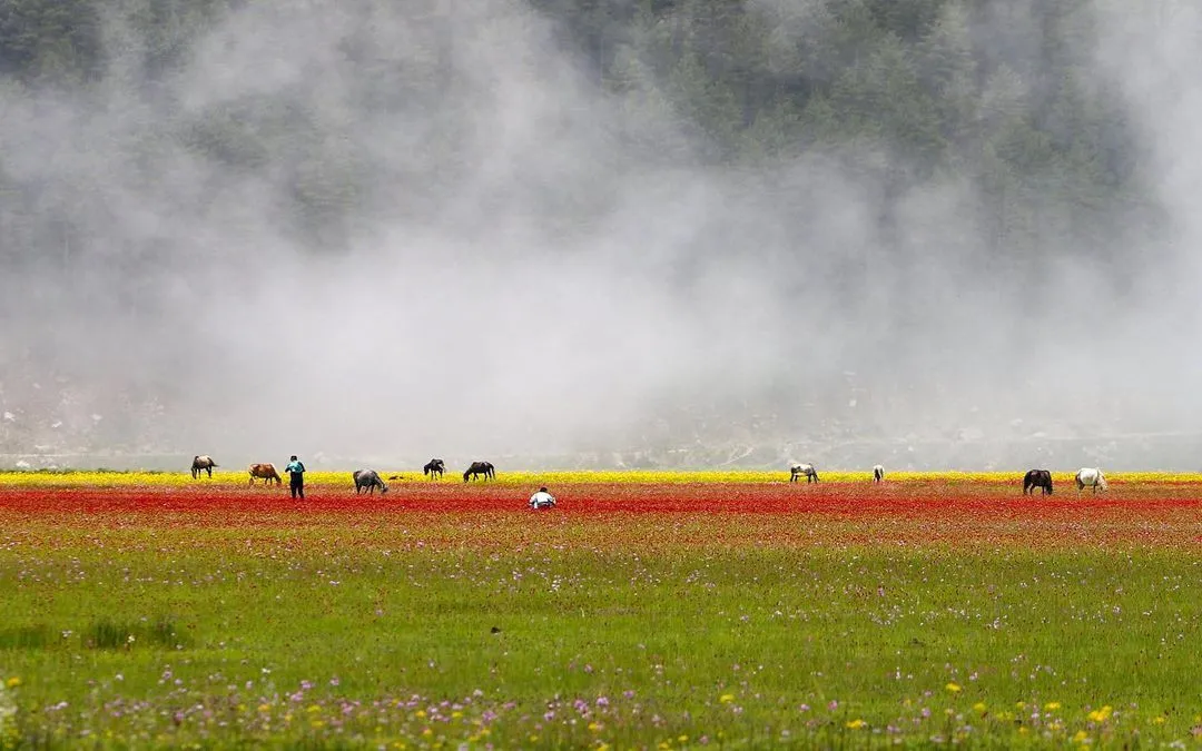
The reserve is high open valley country used for grazing, with blue sheep, Himalayan tahr and a managed hunting block system alongside a much larger area used for ordinary trekking. Anyone heading there needs to arrange permits in advance, and the walking is genuine multi-day expedition travel with no lodge network. The detail is in our Dhorpatan Hunting Reserve guide.
Rukum West at a glance
| Item | Detail |
|---|---|
| Province | Karnali Province |
| District headquarters | Musikot, on a ridge above the Bheri valley |
| Created | 2017, following the provincial boundary drawn in the 2015 constitution |
| Main market town | Chaurjahari, on the Bheri |
| Terrain | Under 1,000 m in the Bheri valley, terraced middle hills, grazing country above 3,000 m in the north |
| Main river | The Bheri, flowing down from Dolpa toward the Karnali |
| Neighbours | Dolpa, Rukum East, Rolpa, Salyan, Jajarkot |
| Airstrip | Chaurjahari, with intermittent service; Nepalgunj is the dependable airport |
| From Nepalgunj | A long day by road, longer in the monsoon |
| Best months | October to November and March to May |
How to reach Rukum West
The dependable route is road from Nepalgunj: north through Kohalpur to Surkhet, then east and north on the Bheri corridor through Jajarkot and on to Chaurjahari and Musikot. Buses and shared jeeps run it daily and it is a long day at best. Coming from the east, the road from Rolpa and the Dang valley is the other option and is shorter if you are already in that part of Lumbini Province.
Chaurjahari has an airstrip. It sees intermittent service and is a useful contingency rather than a plan, and no itinerary should assume a seat on it. Anyone weighing flight against road across the region will find the corridors set out in our guide to getting to west Nepal, and a workable multi-district sequence in our ten-day Karnali circuit itinerary.
The conflict years and after
Rukum and neighbouring Rolpa are where the Maoist insurgency began in 1996, and both districts were at the centre of the conflict for the decade that followed. That history is not hidden here. It is referenced in place names, in memorials and in ordinary conversation, and it explains why so much of the district's road, school and health-post infrastructure dates from after 2006.
Two more recent events are worth knowing. In May 2020 six people died in an incident at Soti in Rukum West, widely reported as caste-based violence, and the case has been through the courts since; caste discrimination remains a live legal and social issue across the Karnali hills rather than a settled one. And in November 2023 the earthquake centred in neighbouring Jajarkot killed dozens of people in Rukum West and destroyed a large number of stone-and-mud houses, with reconstruction still incomplete well afterwards.
None of this makes the district difficult to travel in. It does mean a visitor who arrives with no context will misread what they are looking at, which is the argument for reading a paragraph like this one before rather than after.
What the district lives on
Rukum West is farming country with a high-altitude sideline. The terraces carry maize, millet, wheat and potato, rain-fed and on slopes steep enough that ploughing is done with oxen because nothing else fits. Livestock go up to the summer pasture on the northern ridges and come back down before the first serious snow, which is the same vertical pattern that runs through every Karnali district.
The sideline is collection. Yarsagumba, the caterpillar fungus gathered on the high pastures in late spring and sold into the Chinese medicinal market, brings more cash into some households than a year of farming does, and it distorts the calendar in ways a visitor will notice. In collection season the villages empty upward, schools thin out, and porters and pack animals become scarce and expensive precisely when the weather is good. Anyone planning to hire help in May or June should ask early and expect to pay more.
The third income is migration. Seasonal work in India and longer contracts in the Gulf and Malaysia underwrite household spending here as they do across the province, and the demographic effect is plain in any village during the working season. It also explains the construction you will see: a concrete-and-rebar house among stone-and-mud ones is usually remittance money, and after 2023 it is also a deliberate choice about what survives an earthquake.
What there is to see
Nothing in Rukum West is a headline attraction and the district does not pretend otherwise. Musikot itself is worth a slow morning: a ridge town with long views in both directions, a bazaar that serves the whole district, and the ordinary business of a hill headquarters going on around you. Chaurjahari, down on the Bheri, is the commercial counterweight, hotter, busier and the place things actually arrive.
The walking is the reason to stay. Ridge paths link villages that the road has not reached, the northern grazing country above three thousand metres opens out in summer, and the Bheri gorge is genuinely dramatic where the road runs above it. There are no marked routes and no lodges, so this is walking arranged locally, day by day, with someone who knows which household will feed you.
Best time to visit Rukum West
October to November and March to May. Autumn is the most reliable stretch for both roads and weather, and it follows the harvest. Spring is warm in the valley and pleasant higher up, and it is the window for anyone heading east toward Dhorpatan, where the high country only opens once the snow has gone.
The monsoon between mid June and September closes the Bheri corridor repeatedly with landslides and should be avoided for anything with a schedule attached. Winter is cold on the ridges, snow reaches the higher settlements, and the northern routes toward Dolpa are shut. The seasonal pattern across the region is set out in our guide to the best time to visit west Nepal.
Where to stay and what to expect
Musikot and Chaurjahari both have basic guesthouses serving government staff, traders and development workers. Simple rooms, shared facilities, dal bhat, intermittent hot water. Away from those two towns, accommodation means a homestay negotiated on the day, and the 2023 earthquake reduced what limited capacity existed in the smaller settlements.
There are bank branches and ATMs in the two main towns and they are not reliable enough to depend on, so draw the cash for the whole leg in Nepalgunj or Surkhet. Mobile coverage follows the road and the ridge settlements and vanishes in the side valleys. There is no trekking infrastructure, no marked trail network and no rescue capability, so anything off the road wants a local guide, less for route-finding than for arranging beds and food in a district with no visitor economy.
Frequently Asked Questions
What is the difference between Rukum West and Rukum East?
They are the two halves of the old Rukum district, separated when the 2015 constitution drew a provincial boundary through it. Rukum West is in Karnali Province with its headquarters at Musikot. Rukum East is in Lumbini Province with its headquarters at Rukumkot.
Is Dhorpatan Hunting Reserve in Rukum West?
No. The reserve lies to the east, across Rukum East, Baglung and Myagdi. Rukum West is one of the western approaches to it, and the Bheri corridor through Chaurjahari is the route in for anyone coming from Nepalgunj or Surkhet.
How do you get to Musikot in Rukum West?
By road from Nepalgunj through Kohalpur, Surkhet and the Bheri corridor, which is a long day. Chaurjahari has an airstrip with intermittent service, but it is not dependable enough to plan an itinerary around.
Was Rukum West affected by the 2023 earthquake?
Yes. The earthquake of 3 November 2023 was centred in neighbouring Jajarkot and killed dozens of people in Rukum West, destroying a large number of stone-and-mud houses. Reconstruction remained incomplete long afterwards.
Do you need a permit for Rukum West?
No special trekking permit is required for the district itself. A Dhorpatan Hunting Reserve permit is needed if your route continues east into the reserve, and that must be arranged in advance rather than on arrival.
When is the best time to visit Rukum West?
October to November and March to May. The monsoon closes the Bheri corridor repeatedly with landslides, and winter brings snow to the ridges and shuts the northern routes toward Dolpa.
