
Rukum East is a mountain district in the far north of Lumbini Province, western Nepal, with its headquarters at Rukumkot. It was created in 2015 when the old Rukum district was divided, sending the eastern part to Lumbini Province and the western part to Karnali. It covers around 1,161 square kilometres, contains three rural municipalities, and is dominated by Sisne Himal at 5,849 metres.
This is the least populated and least visited district in the province by a wide margin. It has no airstrip, no lodge network and, for a long stretch of its recent history, no road worth the name. What it does have is high country: alpine pasture, forest, herding routes and a Kham Magar culture continuous with neighbouring Rolpa. Anyone who ends up here has either come deliberately or has taken a wrong turn on the way to Dolpa.
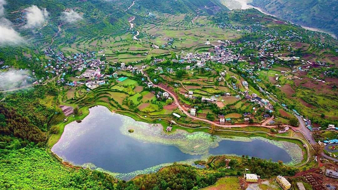
The 2015 split, and why it still confuses people
Until 2015 there was one Rukum district, headquartered at Musikot in the west. The constitution promulgated that year restructured Nepal into seven provinces, and the provincial boundary drawn through the region cut Rukum in two. Western Rukum, keeping Musikot and the larger share of the population, went to Karnali Province. Eastern Rukum, with a new headquarters at Rukumkot, went to Lumbini Province.
The practical consequences are real. The two halves share a name, a language, a culture and a road, and are administered from two different provincial capitals. Older maps, older statistics and a great deal of published writing treat Rukum as a single unit, which means any figure you find needs checking against its date. When someone in the district says Rukum without qualification, they usually mean the whole historical area rather than either half of it.
Rukumkot and the three rural municipalities
Rukumkot is the district headquarters, and it is a village that was given an administrative job in 2015 rather than a town that grew into one. The offices are there, a small bazaar has formed around them, and the transformation is visibly still in progress. The kot in the name refers to the hill fort that gave the whole region its identity under the Baise principalities, and the ridge above the settlement carries the traces of it.
The district is divided into three rural municipalities and no municipalities at all, which is itself a statement about how rural it is. Putha Uttarganga takes its name from the Uttarganga river and from Putha Hiunchuli, the 7,246 metre peak at the western end of the Dhaulagiri range that rises just beyond the district's northern limit. Sisne is named for the mountain that dominates the skyline. Bhume takes its name from the land festival that is the defining Kham Magar observance of the region.
Sisne Himal
Sisne, sometimes called Murkatta Himal, stands at 5,849 metres and is the highest point in the district. It is not a climbing objective in any commercial sense and it is not a trekking peak with a permit route. What it is, for a visitor, is the fixed reference on the northern horizon from almost anywhere in the district, and the reason the high pastures below it hold snow well into the spring.
The country beneath the mountain is summer grazing: open ground above the tree line, herder shelters, and sheep and cattle brought up from the villages once the snow clears. Walking there is entirely unsupported. No lodges, no marked trail, no rescue. It is genuinely fine country and it asks for a tent, carried food, several spare days and a local guide who has been up before.
Rukum East district at a glance
| Fact | Detail |
|---|---|
| Province | Lumbini Province |
| District headquarters | Rukumkot |
| Area | About 1,161 square kilometres |
| Created | 2015, when Rukum was divided between Lumbini and Karnali provinces |
| Local units | Three rural municipalities: Putha Uttarganga, Sisne and Bhume |
| Highest point | Sisne Himal, 5,849 m |
| Elevation range | Roughly 1,000 m in the river valleys to 5,849 m at Sisne |
| Journey time from Kathmandu | Two days by road via Dang and Rolpa in reasonable conditions |
Kham Magar culture and the Bhume dance
Rukum East shares its culture with Rolpa immediately to the south-west. The dominant community is Kham Magar, speaking Kham, a Tibeto-Burman language separate from Magar proper and still in everyday use across the northern villages. The economy runs on terraced grain, livestock moved between altitudes with the season, and remittances, in roughly that order of visibility and the reverse order of household income.
Bhume, in Jestha around May and June, is the festival that defines the local year. Villages dance for several days in slow lines around the communal ground, and the observance is directed at the land itself. Shamanic practice is widespread and coexists with Hindu ritual without much comment from anybody. As across the region, a foreign visitor arriving for Bhume is an unusual event, and the courtesy is to ask before joining in or photographing.
Before the split: Rukum in the Baise period
Rukum was one of the Baise, the twenty-two small principalities of the Karnali basin that emerged as the Khas Malla kingdom fragmented from the fourteenth century onwards. The seat was the fort at Rukumkot, and the territory it controlled covered both halves of what are now two districts in two provinces. Gorkha absorbed the region in the second half of the eighteenth century during the campaign that produced modern Nepal.
What survives is the same as everywhere else in the western hills: fort terracing on ridge tops, shrines that outlasted the courts they served, and place names ending in kot that mark where a garrison once sat. None of it is presented or interpreted for visitors. The value of knowing it is that it explains why the two Rukums feel like one place to the people who live there and like two administrative units to everybody else. Our account of the kingdom whose collapse produced the Baise is at the lost Khas Malla kingdom.
What there actually is to do
This needs stating plainly, because a district guide that implies an itinerary where none exists does the reader no favours. Rukum East has no museum, no marked trail, no viewpoint with a road to it and no organised activity of any kind. What it offers is walking country, villages that see almost no outside visitors, and the Bhume festival if your dates land right.
The realistic plan is to base at Rukumkot for a couple of nights, arrange a local guide through the lodge or the rural municipality office, and walk out into one of the valleys for two or three days with a tent and food. The high ground below Sisne is the obvious objective. The eastern side of the district runs up against the Dhorpatan Hunting Reserve, and walking routes connect through, though that crossing needs proper planning and the reserve has its own permit arrangements.
Anyone treating Rukum East as a stop rather than a destination usually does so on the way between Rolpa and Dolpa or between the Lumbini hills and Karnali Province, which is a reasonable use of it and takes two days.
How to get to Rukum East
There is no airstrip in the district, so everything comes by road, and the road is the whole difficulty. The practical route runs from the Mahendra Highway at Bhalubang or Lamahi in Dang, north through Tulsipur and Sulichaur to Liwang in Rolpa, and then north again to Rukumkot. From Kathmandu that is two days rather than one, and the second day is slow. An alternative approach comes from Surkhet through Rukum West, which is the way people from Karnali Province arrive.
Shared jeeps are the realistic transport and they run when they fill. Sections of the route are unsealed and monsoon landslides close them for days at a time. Nobody should plan a tight schedule into this district. The regional access picture is set out in how to get to west Nepal, and the high reserve on the district's eastern boundary in the Dhorpatan Hunting Reserve guide.
When to go and what to expect
Late September to November and April to early June. Autumn gives the most stable weather and the clearest views of Sisne and the Dhaulagiri peaks beyond it. Spring is warmer, greener and coincides with Bhume at the end of the window. Winter closes the high ground with snow and makes the ridge roads unreliable, and the monsoon closes the roads outright.
One thing to plan for that catches people out: the seasons that suit the high ground and the seasons that suit the roads do not fully overlap. The pastures below Sisne are clear of snow from roughly late May, which is also when the pre-monsoon rain starts damaging the approach roads, and they close again from November while the roads are still perfectly usable. October is the one month where both work comfortably, which is why it is the month to aim for if you have a choice.
Accommodation is a small number of basic lodges at Rukumkot and homestay arrangements everywhere else. Carry cash, because banking is minimal. Mobile coverage exists in the main valleys and nowhere above them. No permit is required and the district is not a restricted area, but identification is worth carrying. This is a place for travellers with time, patience and either functional Nepali or a good local guide. Further reading on the region sits at Rukum and Rolpa, and for a sense of how the far northern districts compare, the Dolpa district guide.
Frequently Asked Questions
Where is Rukum East district?
Rukum East is in the far north of Lumbini Province, bordering Rolpa to the south-west, Rukum West in Karnali Province to the west, and Dolpa and Myagdi to the north and east. Its headquarters is Rukumkot.
Why was Rukum split into two districts?
The 2015 constitution restructured Nepal into seven provinces, and the new provincial boundary ran through the old Rukum district. Eastern Rukum went to Lumbini Province with a new headquarters at Rukumkot, and Western Rukum stayed with Musikot in Karnali Province.
How high is Sisne Himal?
Sisne, also known as Murkatta Himal, reaches 5,849 metres and is the highest point in Rukum East. It gives its name to one of the district's three rural municipalities.
What are the local units of Rukum East?
Three rural municipalities and no urban municipality: Putha Uttarganga, Sisne and Bhume. The absence of a municipality is a fair indicator of how rural the district is.
How do you get to Rukum East?
By road only. The usual route runs from the Mahendra Highway in Dang north through Tulsipur, Sulichaur and Liwang in Rolpa to Rukumkot, which takes two days from Kathmandu. An alternative approach comes from Surkhet through Rukum West.
Is there trekking in Rukum East?
Only unsupported walking. There is no lodge circuit, no marked trail and no rescue infrastructure, so the high pastures below Sisne require a tent, carried food and a local guide.
When is the best time to visit Rukum East?
Late September to November and April to early June. Winter closes the high ground with snow, and the monsoon closes the single road route with landslides.
