
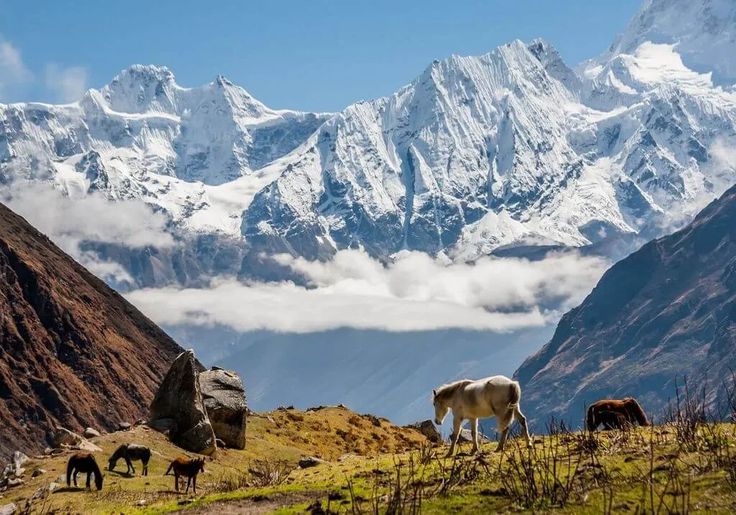
The Manaslu Conservation Area protects 1,663 square kilometres of northern Gorkha district around Manaslu, the eighth highest mountain on earth at 8,163 metres. It was established in 1998 and is managed by the National Trust for Nature Conservation, with roughly nine thousand residents still living inside the boundary in the Nubri and Tsum valleys. The whole area is a government restricted zone, so trekkers need a restricted-area permit arranged through a registered agency, a licensed guide and a minimum party of two.
What is the Manaslu Conservation Area and why is it restricted?
The conservation area follows the Budhi Gandaki from the middle hills at around 600 metres to the summit ridge of Manaslu, a rise of more than seven and a half kilometres in about eighty of horizontal distance. It was declared in 1998 and handed to the National Trust for Nature Conservation, the same non-government body that runs Annapurna and Gaurishankar. The restricted-zone designation is older than the conservation area and has a different purpose. It exists because the valley heads sit hard against the Tibetan border, and Nepal controls access to every such corridor, from Humla in the far west to Kanchenjunga in the east.
In practice restriction has been good for the landscape. Manaslu opened to organised trekking only in 1991, three decades after Everest and Annapurna, and the permit conditions have kept numbers low ever since. Villages above Jagat still run on subsistence agriculture, yak and buffalo herding, and trade over the passes, with lodge income supplementing rather than replacing that base. You can walk for a week without seeing a road, a power line or a mass-market teahouse of the kind that lines the lower Annapurna trails.
How does a conservation area differ from a national park in Nepal?
A Nepali national park is strict protection under the National Parks and Wildlife Conservation Act of 1973. No permanent settlement is allowed inside the core zone, resource extraction is prohibited, and the Nepal Army garrisons the boundary while the Department of National Parks and Wildlife Conservation manages the interior. A conservation area, governed by the Conservation Area Management Regulations of 1996, is a multiple-use category built around the people already living there. Farming, controlled grazing, quota-based collection of firewood, timber and medicinal plants, and private tourism enterprise all continue legally inside the line.
The management structure differs as much as the rules. Manaslu is administered through Conservation Area Management Committees elected in the settlements themselves, with the trust providing technical staff, monitoring and funding rather than enforcement. There are no soldiers. Entry fee income is retained for local conservation and development, which in Nubri and Tsum has meant trail bridges, school buildings, micro-hydro, and the rebuilding programme that followed the 2015 earthquake. Nepal has six conservation areas in total, three of them managed by the trust, one by the department and one, Kanchenjunga, by a community council since 2006.
What does the Manaslu Circuit route look like?
The standard circuit starts at Machha Khola or Soti Khola in the humid lower gorge and finishes at Dharapani in the Marsyangdi, where it joins the Annapurna trail network. The climb is unusually steady, which is one reason the route acclimatises well, and the change in culture from Hindu middle hills to Tibetan Buddhist high valleys happens over about four walking days.
| Section | Approximate altitude | Typical nights | What changes |
|---|---|---|---|
| Machha Khola to Jagat | 870 m to about 1,340 m | 2 | Hot gorge, waterfalls, Hindu villages, permit checkpost at Jagat |
| Jagat to Deng | About 1,340 m to 1,860 m | 1 to 2 | Gorge narrows, first mani walls and Buddhist prayer flags |
| Deng to Namrung | About 1,860 m to 2,630 m | 1 to 2 | Pine and fir, Tibetan-influenced stone housing, Tsum junction below |
| Namrung to Samagaun | About 2,630 m to 3,530 m | 2 | Manaslu comes into full view, barley terraces, Birendra Tal glacial lake |
| Samagaun to Samdo and Dharamsala | About 3,530 m to 4,460 m | 2 to 3 | Treeless, yak pasture, last permanent village at Samdo |
| Larke La to Bimthang and Dharapani | About 5,100 m down to 1,860 m | 2 | Long pass day, glacier moraine, then rapid descent into the Marsyangdi |
Most itineraries run fourteen to eighteen days from Kathmandu including transport, and the pass day from Dharamsala is the crux: a pre-dawn start, roughly 700 metres of climb and 1,500 metres of descent, on ground that holds snow well into spring. Many parties add two nights at Samagaun for acclimatisation, walking up to Birendra Tal or the Pungyen Gompa on the rest day rather than sitting still.
What wildlife lives in the Manaslu Conservation Area?
The altitude range gives the area an unusually complete set of Himalayan habitats, from subtropical riverine forest through oak, fir and birch to alpine pasture and permanent ice. Snow leopard occupy the upper Nubri and the ridges above Samdo, where blue sheep graze in visible herds and provide the main prey base. Himalayan tahr, musk deer, Himalayan black bear and grey wolf are all recorded, and the trust has run camera-trap monitoring in the higher valleys for years. Red panda occur in the bamboo understory of the middle-elevation forests, though sightings on the main trail are rare enough to count as luck.
Birdlife follows the same vertical logic. Himalayan monal, blood pheasant and snow partridge hold the alpine and subalpine zones, lammergeier and Himalayan griffon quarter the gorge walls, and the forest belt around Namrung and Lho carries laughingthrushes, minivets and a good spring passage of warblers. Plant collection is legal under quota, and the alpine meadows above Samdo are worked hard for yarsagumba in May and June, which is worth knowing because it is the one time of year the high pastures are crowded with Nepali collectors rather than trekkers.
What is the Tsum Valley and should you add it?
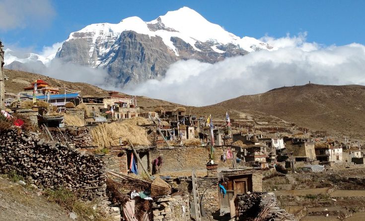
Tsum branches north-east from the main Budhi Gandaki below Namrung and opened to foreign trekkers only in 2008. It is a self-contained Tibetan Buddhist valley with its own dialect, its own gompas at Rachen and Mu, and a long-standing local declaration of non-violence under which animal slaughter and hunting are renounced. That tradition, combined with the late opening, has left the valley culturally intact in a way few places in Nepal still are.
Adding Tsum costs about six to eight extra days and a second restricted-area permit, and it can be walked as a standalone trip that returns the way it came rather than crossing Larke La. If your interest is monastic culture and quiet rather than pass crossings and high peaks, Tsum is the better half of the region. Mu Gompa sits at roughly 3,700 metres near the head of the valley with the Tibetan border a short walk beyond, and the hermitages cut into the cliffs above it are still occupied.
When is the best time to trek Manaslu?
October and November are the strongest months: settled weather, clear views of Manaslu from Samagaun, and Larke La usually open. Late March to May is the second window, with rhododendron in the lower forests and longer daylight for the pass, but more haze and a real chance of fresh snow on the crossing into April. Monsoon from mid-June to early September makes the lower gorge slippery and leech-ridden and the pass unreliable, and December to February closes Larke La with snow for extended periods, though the walk in to Samagaun and back is feasible for well-equipped parties.
Because the route ends at Dharapani, many trekkers continue west into the Annapurna Circuit rather than driving straight back to Kathmandu, and a smaller number detour north into Nar Phu. If you want the same trans-Himalayan character with a drier climate and a longer season, Upper Mustang stays walkable through the monsoon because it sits in the rain shadow.
What did the 2015 earthquake do to the region?
The earthquake of 25 April 2015 had its epicentre in Gorkha district, and the Manaslu valleys were among the worst affected places in the country. Villages lost houses and gompas, landslides took out sections of trail, and the trekking season collapsed for more than a year. Reconstruction has since restored the route end to end, and lodges above Jagat were largely rebuilt to better standards than what stood before. Landslide scars are still visible on the gorge walls between Jagat and Deng.
The recovery is worth understanding because it explains the current character of the trek. Tourism income was the fastest cash to reach these villages after the disaster, and the conservation area structure meant permit revenue and lodge earnings stayed in the district rather than flowing to Kathmandu operators alone. Walking Manaslu now is one of the more direct ways a visitor can put money into a mountain economy that needed it, which is a better argument for the route than any view.
FAQ
Do you need a special permit for the Manaslu Conservation Area?
Yes. Manaslu is a restricted area, so you need a restricted-area permit issued only through a registered Nepali trekking agency, plus the Manaslu Conservation Area entry permit and, because the route exits at Dharapani, an Annapurna Conservation Area permit as well.
Can you trek Manaslu alone?
No. Restricted-area rules require a minimum of two trekkers on one permit and a licensed guide from a registered agency. Solo trekking is not permitted anywhere inside the restricted zone.
How high is Larke La?
The pass sits at roughly 5,100 metres and is the highest point of the circuit. It is crossed in a single long day from Dharamsala, with about 700 metres of ascent and a descent of around 1,500 metres to Bimthang.
Is Manaslu harder than the Annapurna Circuit?
Slightly. The pass is a little lower than Thorong La but the approach is longer, the lodges are simpler, there is no road bail-out for most of the route and evacuation options are thinner. Fitness requirements are similar; the difference is in remoteness and in having to carry a proper contingency plan.
How many people live inside the Manaslu Conservation Area?
Roughly nine thousand, mostly in the Nubri and Tsum valleys. They continue to farm, herd and trade inside the boundary, which is the practical difference between a conservation area and a national park in Nepal.