
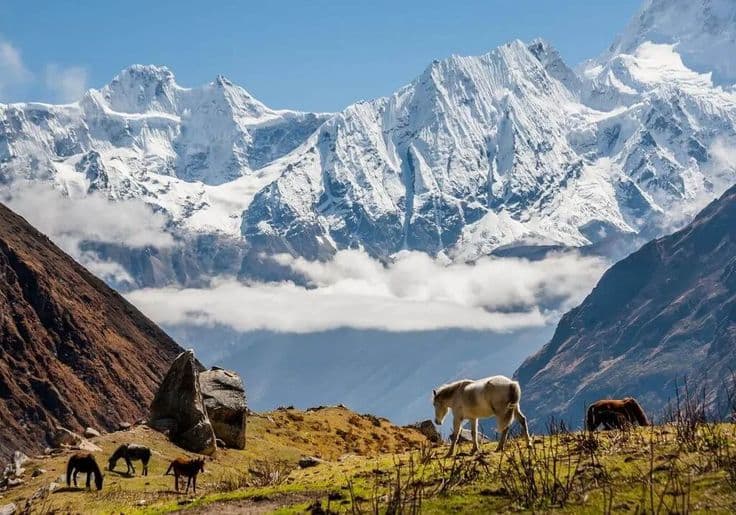
The Manaslu Circuit follows the Budhi Gandaki gorge north from Gorkha district, rounds Manaslu at 8,163 m and crosses the Larkya La at 5,106 m into Manang, where it joins the Annapurna Circuit at Dharapani. It is a restricted area, so a licensed guide, a registered agency and at least two trekkers are required.
| Detail | Figure |
|---|---|
| High point | Larkya La, 5,106 m |
| Manaslu summit | 8,163 m, eighth highest in the world |
| Start | Machha Khola or Soti Khola, Gorkha district |
| Finish | Dharapani, Manang district |
| Province | Gandaki |
| Protected area | Manaslu Conservation Area |
| Walking days | 14 to 18 |
| Best months | March to May, September to November |
What the restricted-area rule actually means
Manaslu is not a route you can walk alone. The restricted-area permit is issued only through a registered Nepali trekking agency, only to a group of two or more trekkers, and only with a licensed guide named on it. Solo permits are not available, and agencies sometimes pair single walkers to make up the minimum. On top of the restricted permit you need the Manaslu Conservation Area permit and, because the trek exits into the Annapurna region, the Annapurna Conservation Area permit as well.
The restricted permit is priced per person for a fixed initial period with a per-day extension, and the rate is higher in the September to November season than for the rest of the year. Treat any quoted figure as something to confirm with your agency at the time of booking. The mechanics of these permits, and how they compare with Dolpa, Humla and Mugu, are covered in our guide to restricted-area permits.
The rule is why the trail is quiet. Manaslu carries a fraction of the traffic of the Annapurna and Everest routes despite comparable scenery, and the lodges are not overrun in October.
The gorge, then the high valleys
The first three days are the hard-to-love part: a hot, humid climb up the Budhi Gandaki through subtropical forest, on a trail cut into the gorge wall with long suspension bridges and a fair amount of exposure. A road now reaches Machha Khola and sometimes further, so most itineraries start there rather than at Arughat and save a day.
Above Jagat the valley opens and the character changes completely. Deng, Namrung and Lho mark the transition from Nepali hill villages to Tibetan Buddhist ones: mani walls, chortens, barley terraces and monasteries. Lho gives the first full sight of Manaslu. Samagaun at about 3,530 m is where the trek pauses for two nights, with day walks to Pungyen Gompa or to Manaslu Base Camp and Birendra Lake for acclimatisation. Samdo at 3,875 m follows, a village of Tibetan origin close enough to the border that its trading history is still visible in the households.
Crossing the Larkya La
The last camp is Dharamsala, also called Larke Phedi, at around 4,460 m. It is one stone building and some huts, and it is cold and often full. Groups leave between three and four in the morning to cross the Larkya La at 5,106 m before the wind, and the crossing day is long: five hours up over moraine and, if there is snow, a slow glacier bench, then a steep, loose 1,500 m drop to Bimthang on the far side.
This is the day the trek is judged on. It is not technical, but it is high, exposed and long, and in bad weather it is genuinely serious. Poles and micro-spikes are worth carrying from October onwards. From Bimthang the descent to Dharapani takes a day and a half through pine forest, and there you meet the road and the Annapurna trail. Some walkers keep going and continue round the Annapurna Circuit; most take a jeep to Besisahar.
The mountain and the landscape you are circling
Manaslu was first climbed by a Japanese expedition in 1956 and remains one of the more dangerous 8,000 m peaks for climbers, with avalanche-prone slopes on the standard route. Our Manaslu mountain guide covers the climbing history, and the eight-thousanders of Nepal sets it against the other seven.
The conservation area around it is managed with the villages rather than over them, and it protects snow leopard, Himalayan tahr and blue sheep across an altitude range that runs from subtropical gorge to permanent ice within four days of walking. Our Manaslu Conservation Area guide covers the wildlife and the management model.
When to go and what to expect of the lodges
Late September to November is the main season, with settled weather and open lodges across the pass. March to May works well and is quieter, though snow on the Larkya La lingers into April in a heavy year. December to February closes the pass in practice: Dharamsala shuts, and being caught at 4,460 m without shelter is not a recoverable mistake. The monsoon makes the lower gorge dangerous for landslides.
Lodges exist the whole way now and are simple: twin rooms, a dining stove, and menus that shrink as you climb. Samagaun and Samdo have basic shops. There is no ATM after Arughat, no reliable mobile signal above Namrung, and charging is paid for by the device. Carry all the cash the trek needs from Kathmandu.
Frequently Asked Questions
Can you trek Manaslu without a guide?
No. Manaslu is a restricted area. The permit is issued only through a registered Nepali agency, requires a licensed guide, and requires a minimum of two trekkers on the same permit.
How high is the Larkya La pass?
5,106 m. It is crossed on a single long day from Dharamsala at about 4,460 m, with a steep 1,500 m descent to Bimthang on the far side. No technical climbing is involved.
How many days is the Manaslu Circuit?
Fourteen to eighteen walking days from Machha Khola to Dharapani, including two nights at Samagaun for acclimatisation. Continuing onto the Annapurna Circuit adds a further week or more.
Is Manaslu harder than the Annapurna Circuit?
Yes, moderately. The passes are a similar height, but Manaslu has longer days, rougher trail in the gorge, fewer facilities and a harder single crossing day, and it cannot be shortened by jeep in the middle.
How many permits does the Manaslu Circuit need?
Three: the restricted-area permit, the Manaslu Conservation Area permit and the Annapurna Conservation Area permit for the exit through Dharapani. Your agency arranges all three together.