
Manaslu is 8,163 metres, the eighth highest mountain in the world, and it stands at the head of the Budhi Gandaki valley in Gorkha District, roughly 100 kilometres northwest of Kathmandu. The name derives from the Sanskrit manasa, meaning intellect or spirit, and is usually rendered as mountain of the spirit. It was first climbed on 9 May 1956 by Toshio Imanishi and the Sherpa Gyalzen Norbu, on a Japanese expedition led by Yuko Maki.
Where is Manaslu and what surrounds it?
The peak is the high point of the Mansiri Himal, a compact group north of the Gorkha hills and east of the Annapurna range. The Budhi Gandaki river drains the whole eastern side of the massif, cutting a deep gorge south toward the Trishuli. That gorge is the approach, and it is why the trek around Manaslu begins in subtropical forest at a few hundred metres and ends on a glaciated pass above 5,000 metres.
The upper valley is Tibetan in culture and language. Samagaun at 3,530 metres and Samdo at 3,875 metres are Nubri villages with gompas, chortens and yak herding, close enough to the Tibetan border that trade across it shaped the settlements. The neighbouring Tsum Valley, branching northeast at Lokpa, is a separate Tibetan Buddhist enclave with its own dialect, its own monasteries and a long-standing local pact of non-violence that extends to a prohibition on killing animals.
The whole area falls inside the Manaslu Conservation Area, established in 1998 and covering roughly 1,660 square kilometres. It protects snow leopard, Himalayan tahr, blue sheep and Himalayan musk deer across an altitude range from about 600 metres to the summit itself, one of the steepest vertical gradients in any Nepali protected area.
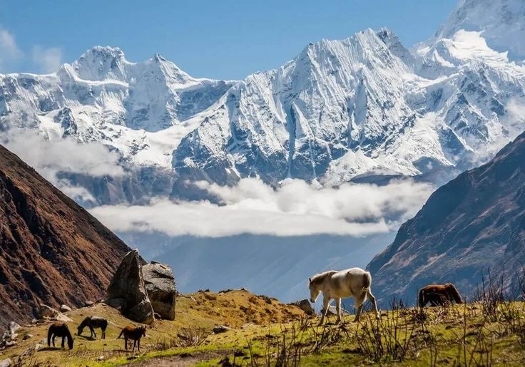
Why is Manaslu called the Japanese mountain?
For the same reason Everest is remembered as British and Nanga Parbat as German: one country invested in it repeatedly until it was climbed. Japanese expeditions reconnoitred and attempted Manaslu through the early 1950s and made the first ascent in 1956, when Toshio Imanishi and Gyalzen Norbu reached the summit on 9 May under the leadership of Yuko Maki.
What is less often told is what happened in between. In 1953 an avalanche destroyed the Pungyen Gompa above Samagaun, and villagers connected the disaster to the presence of foreign climbers on a mountain understood as the abode of local deities. The 1954 expedition was met with open opposition and could not proceed. Relations were only repaired over subsequent years, with Japanese support contributing to the rebuilding of the monastery, and the 1956 expedition went ahead with local agreement.
That episode is the reason the phrase mountain of the spirit is more than a translation flourish here. The gompas above Samagaun are working monasteries, the mountain has a name in local religious practice as well as on the survey sheets, and the community below it has a documented history of refusing an expedition on religious grounds. It is worth knowing before you walk through.
How dangerous is Manaslu?
Serious, and more serious than its recent popularity suggests. Manaslu has become the busiest eight-thousander after Everest for commercial expeditions, partly because the permit and logistics are simpler than Everest and partly because it is used as a preparation climb. That volume has not made the mountain safer.
The normal northeast route crosses avalanche-prone slopes and a heavily crevassed glacier. In September 2012 an avalanche struck Camp 3 and killed eleven climbers, one of the worst single incidents on the mountain. There is also a long-running dispute over what counts as the true summit: many ascents historically stopped at a fore-summit short of the corniced final point, and the distinction has become a live issue in record-keeping.
For trekkers none of this applies directly, but the weather that causes it does. The Larkya La at 5,106 metres is exposed, the descent on the west side is long and it holds snow. Groups have been trapped by storms on the Dharamsala side. Treat the pass day as the one day of the trek that genuinely requires a forecast and a willingness to wait.
What does the Manaslu Circuit trek involve?
The circuit follows the Budhi Gandaki north from the roadhead at Machha Khola or Soti Khola, climbs through the gorge to the Nubri villages, crosses the Larkya La and descends west into the Marsyangdi at Dharapani, where it joins the Annapurna Circuit. Most itineraries take 14 to 18 days including a rest day at Samagaun. It is a teahouse trek throughout, though the lodges are simpler than on the Annapurna side and thin out sharply above Samdo.
| Stage | Approx. elevation | What changes here |
|---|---|---|
| Machha Khola | 870 m | Road head; subtropical gorge, hot and humid |
| Jagat | 1,340 m | Restricted-area checkpost; permits inspected |
| Deng | 1,860 m | Language and architecture start turning Tibetan |
| Namrung | 2,630 m | First open views of Himalchuli and Ganesh Himal |
| Lho | 3,180 m | Ribung Gompa; first full view of the Manaslu summit |
| Samagaun | 3,530 m | Main acclimatisation stop; Birendra Tal and base camp day walks |
| Samdo | 3,875 m | Last permanent village; old Tibetan trade route |
| Dharamsala | 4,460 m | Basic pass-day shelter, cold and crowded in season |
| Larkya La | 5,106 m | High point; long exposed descent to the west |
| Bimthang | 3,720 m | Meadow below the west face; the hard walking ends |
Manaslu is a restricted area. Trekking it requires a restricted-area permit arranged through a registered agency, along with Manaslu Conservation Area and Annapurna Conservation Area entry permits, since the exit at Dharapani lies inside the latter. A registered guide and a minimum party size are required, and permit costs vary by season. All of these rules have been revised more than once, so confirm the current position with the Department of Immigration before booking.
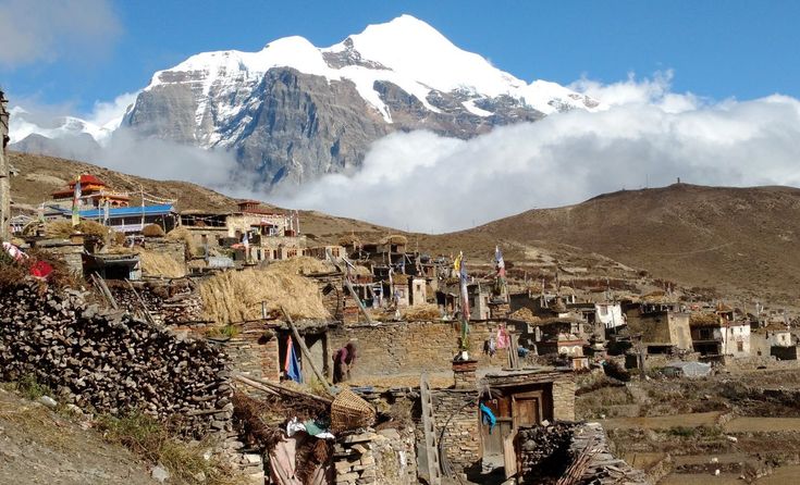
What is worth doing at Samagaun?
Samagaun is the one place on the circuit where a rest day pays for itself twice, once for acclimatisation and once for what is within walking distance. At 3,530 metres it is the natural acclimatisation stop before Samdo and the pass, and nearly every sensible itinerary spends two nights there.
Three day walks leave the village. Birendra Tal is a turquoise glacial lake about an hour away at the snout of the Manaslu Glacier, easy and worth the time. Manaslu Base Camp, at roughly 4,800 metres, is a hard six to eight hour round trip that doubles as excellent acclimatisation and puts you under the north face. Pungyen Gompa sits on a shelf to the east with a direct view of the mountain and carries the history of the 1953 avalanche and the expedition that followed it.
The village itself repays an afternoon. Stone houses, flat roofs stacked with fodder, chortens at the entrances and exits, and a monastery in use. Walk clockwise around mani walls and chortens, ask before photographing people or interiors, and remember that the non-violence customs of the neighbouring Tsum Valley reflect a religious commitment rather than a tourist attraction. The Tsum side trip adds five to seven days and its own permit, and it is the single best addition to the route for anyone with the time.
For season, October and November are the most reliable, with stable weather and open passes. March to May is workable and quieter, with more snow on the Larkya La early in the window. The monsoon closes the gorge section to comfortable walking, and deep winter shuts the pass.
FAQ
How high is Manaslu?
Manaslu is 8,163 metres, the eighth highest mountain in the world. It stands in Gorkha District in central Nepal, at the head of the Budhi Gandaki valley, and is the high point of the Mansiri Himal.
What does the name Manaslu mean?
It comes from the Sanskrit manasa, meaning intellect or spirit, and is normally translated as mountain of the spirit. The mountain also carries local religious significance for the Nubri communities of Samagaun and Lho, whose monasteries sit directly beneath it.
Who made the first ascent of Manaslu?
Toshio Imanishi and the Sherpa Gyalzen Norbu reached the summit on 9 May 1956 on a Japanese expedition led by Yuko Maki. Japanese teams had reconnoitred and attempted the mountain repeatedly through the early 1950s, which is why Manaslu is often called the Japanese mountain.
How high is the Larkya La and how hard is it?
The Larkya La is 5,106 metres and is the high point of the Manaslu Circuit. It is a walking pass rather than a climb, but the day is long, the crossing is exposed to wind and snow, and the descent to Bimthang is a sustained drop of nearly 1,400 metres.
Do you need a guide and a permit for the Manaslu Circuit?
Yes. Manaslu is a restricted area, so the trek requires a restricted-area permit arranged through a registered trekking agency, a registered guide, a minimum party size, and both Manaslu and Annapurna conservation area entry permits. The rules and fees are revised periodically and should be checked before booking.