
Lhotse, at 8,516 metres, is the fourth-highest mountain on earth and is joined to Everest by the South Col at 7,906 metres, while Nuptse, at 7,861 metres, forms the third wall of the same horseshoe around the Western Cwm. Ama Dablam, at 6,812 metres, stands alone further down the Khumbu and is the most photographed mountain in Nepal. All three lie inside Sagarmatha National Park, a UNESCO World Heritage Site since 1979, and all three are visible from the standard Everest Base Camp trail.
What are the peaks around Everest called?
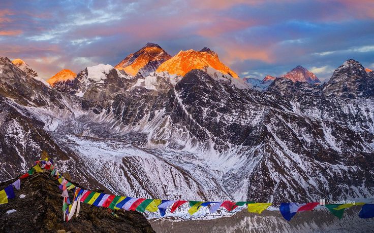
Everest does not stand alone. It is the high point of a horseshoe of three summits enclosing a hanging valley called the Western Cwm, named by George Mallory in 1921. Everest, 8,848.86 metres by the joint Nepal and China survey announced in 2020, sits at the head. Lhotse closes the southern end of the ridge, connected to Everest by the South Col. Nuptse forms the long southern wall of the Cwm and is what most people are actually looking at when they think they are photographing Everest from the trail.
Outside the horseshoe the Khumbu carries a dense set of peaks in the 6,000 to 7,200-metre band: Pumori at 7,161 metres, Ama Dablam at 6,812 metres, Kangtega at 6,782 metres, Thamserku at 6,608 metres, Taboche at 6,542 metres, Cholatse at 6,440 metres and Kusum Kanguru at 6,367 metres. Several of these are more striking to look at than the giants behind them, because they stand clear of their neighbours instead of being lost in a massif.
How high is Lhotse and why is it climbed so rarely?
Lhotse is 8,516 metres, the fourth-highest mountain in the world, and its name means south peak in Tibetan, which describes exactly what it is: the southern summit of the Everest massif. It was first climbed on 18 May 1956 by Ernst Reiss and Fritz Luchsinger of a Swiss expedition. The massif also carries Lhotse Middle at 8,414 metres, first climbed by a Russian team in 2001, and Lhotse Shar at 8,383 metres, making it one of the most complex 8,000-metre structures anywhere.
The oddity of Lhotse is that thousands of people climb most of it every year without intending to. The normal route shares the Khumbu Icefall, the Western Cwm and the Lhotse Face with the standard Everest route, diverging only near Camp 4, so the entire logistical apparatus already exists. Despite that, the summit count is a small fraction of Everest’s, because almost everyone on that ground has paid for the higher mountain. The final couloir is a steep and narrow gully that is more technical than anything on the Everest south side.
The south face of Lhotse is a separate matter entirely. It is roughly 3,200 metres of steep, avalanche-swept ground and has been one of the defining problems of Himalayan alpinism for four decades. A Soviet team put climbers on the summit by that face in October 1990, and it remains a wall very few parties have any business on.
What is Nuptse and why does it look higher than Everest?
Nuptse, 7,861 metres, means west peak in Tibetan and is the third element of the massif. It was first climbed on 16 May 1961 by Dennis Davis and Tashi Sherpa on a British expedition. It is not a single summit but a long serrated ridge with several high points, and because it sits nearly two kilometres closer to the trekking trail than Everest does, it looks dramatically bigger from the valley floor.
That perspective effect is the most common source of confusion on the Everest Base Camp trek. From Tengboche and from most of the Khumbu valley Everest appears as a modest dark triangle behind the Nuptse wall, while Nuptse itself fills the sky. The classic view that resolves the relationship properly is from Kala Patthar, a shoulder of Pumori at around 5,550 metres, where the angle finally puts Everest above the ridge in front of it.
Nuptse is a serious mountain in its own right and one of the least-climbed peaks of its height in Nepal. Its routes are technical, exposed and objectively dangerous, and it has never had commercial traffic. For every hundred people who photograph it, effectively nobody attempts it.
Why is Ama Dablam so famous?
Ama Dablam is 6,812 metres, a fraction of Everest, and yet it appears on more posters, book covers and trip brochures than any other Nepali mountain. The reason is its shape. It stands isolated above the Imja valley with two long ridge arms sweeping down on either side of a steep pyramid, and the hanging glacier below the summit sits on the face like a pendant. The name reads as mother and her necklace: the ridges are the arms, the glacier is the dablam, the ornamented charm box that Sherpa women wear.
It was first climbed on 13 March 1961 by Mike Gill, Barry Bishop, Michael Ward and Wally Romanes, working from the Silver Hut scientific expedition that Edmund Hillary organised in the Khumbu that winter. The normal route is the southwest ridge, a genuinely technical line with rock climbing, mixed ground, a notorious exposed step known as the Yellow Tower and a camp perched on the ridge beneath the hanging glacier. It is graded well above any trekking peak and is climbed mostly in October and November.
Ama Dablam is not a beginner objective and it is not a substitute for a trekking peak. Climbers typically arrive with Island Peak, Lobuche East or an Alpine season behind them. What it offers is one of the finest ridge lines at its grade anywhere in the world, on a mountain you have been looking at for a week on the walk in.
Where can you see these peaks on the trail?
The Khumbu trail is arranged, almost as if designed, to reveal these mountains in sequence. The table below gives the practical viewpoints.
| Peak | Height | First ascent | Normal route | Best trailside viewpoint |
|---|---|---|---|---|
| Everest | 8,848.86 m | 1953, Edmund Hillary and Tenzing Norgay | South Col and southeast ridge | Kala Patthar, about 5,550 m |
| Lhotse | 8,516 m | 1956, Ernst Reiss and Fritz Luchsinger | Western Cwm and Lhotse Face couloir | Chhukhung Ri and the upper Imja valley |
| Nuptse | 7,861 m | 1961, Dennis Davis and Tashi Sherpa | Technical ridges, no commercial route | Everest Base Camp and Gorak Shep |
| Pumori | 7,161 m | 1962, German and Swiss party | Southeast face and ridge | Directly above Gorak Shep and Kala Patthar |
| Ama Dablam | 6,812 m | 1961, Gill, Bishop, Ward and Romanes | Southwest ridge | Tengboche monastery and Pangboche |
| Kangtega | 6,782 m | 1963 | Glaciated faces, infrequently climbed | Tengboche and the Dudh Koshi valley |
| Thamserku | 6,608 m | 1964 | Steep mixed ground, rarely climbed | Namche Bazaar |
| Cholatse | 6,440 m | 1982, American expedition | Southwest ridge, technical | Dzongla and the Cho La approach |
How does the Everest horseshoe compare with Annapurna?
The two great massifs of Nepal are organised differently and it changes what you see. Everest is a compact horseshoe: three summits, one hanging valley, one dominant icefall, all visible from a short stretch of trail. Annapurna is a long chain running roughly east to west, with Annapurna I at 8,091 metres at one end and a sequence of 7,000-metre satellites behind it, which is why the Annapurna Circuit takes days to unwrap what the Khumbu shows you in an afternoon.
In the east, Kanchenjunga at 8,586 metres has the third structure again, a five-summit massif on the Indian border with two of its subsidiary tops above 8,400 metres. All three arrangements produce the same underlying point: in Nepal the second-tier peaks would be national landmarks in any other country.
When should you go and what does it involve?
For trekking, late September to November gives the clearest air of the year and the most reliable mountain views, and March to May gives warmer weather with more haze and more cloud building through the afternoon. Do the walking in the morning; by two in the afternoon the peaks are commonly gone behind cloud in spring. For climbing, Ama Dablam is essentially an October and November mountain, while Lhotse follows the Everest calendar of April and May.
A standard Everest Base Camp trek runs twelve to fourteen days from Lukla and takes you past every viewpoint in the table. Adding Chhukhung Ri or the Gokyo lakes extends it by three to five days and improves the Lhotse and Everest views considerably. Altitude is the constraint throughout: the trail crosses 5,000 metres, the acclimatisation days at Namche and Dingboche are not optional, and helicopter evacuation cover should be in your insurance before you fly to Lukla.
Is it worth going for the second-tier peaks alone?
It is, and a growing number of trekkers now design itineraries around them rather than around base camp. The Gokyo valley, the Cho La crossing and the upper Imja valley to Chhukhung all give better mountain viewing than the base camp moraine itself, which is a rubble-covered glacier with a limited outlook. Base camp is a destination with meaning rather than a viewpoint.
If your object is the mountains themselves, put your nights at Tengboche for Ama Dablam, at Chhukhung for the Lhotse wall, and at Gokyo for the widest panorama in the region. You will see more of the Khumbu and share less of it.
FAQ
Is Lhotse part of Everest?
Lhotse is a separate mountain but part of the same massif. It is joined to Everest by the South Col at 7,906 metres, and its normal route shares the Khumbu Icefall, the Western Cwm and most of the Lhotse Face with the standard Everest route, diverging only near Camp 4 at about 7,900 metres.
Why does Nuptse look taller than Everest from the trail?
Because it is much closer. Nuptse is 7,861 metres against 8,848.86 metres for Everest, but it sits nearly two kilometres nearer the Khumbu valley trail, so it subtends a far larger angle. Kala Patthar, at around 5,550 metres, is the standard viewpoint that finally lifts Everest clear above the Nuptse ridge.
How hard is Ama Dablam to climb?
Considerably harder than any Nepal trekking peak. The southwest ridge involves rock climbing, mixed ground and a steep exposed section known as the Yellow Tower, with camps on a narrow ridge. Climbers normally arrive with prior alpine experience or a 6,000-metre summit already behind them. The season is October and November.
Can you see Ama Dablam without climbing it?
Yes, and it is unavoidable on the Everest Base Camp trek. The classic view is from Tengboche monastery at about 3,867 metres, with the monastery courtyard in the foreground, and the mountain remains in sight through Pangboche and up the Imja valley toward Dingboche and Chhukhung.
What is the best time of year for Everest region mountain views?
Late September to November delivers the clearest air and the most stable weather of the year. March to May is warmer and greener with rhododendron in flower but hazier, and cloud usually builds by early afternoon. In both seasons the peaks are most reliably visible in the first hours after sunrise.